Tsunamis have been a nightmare for the inhabitants of the islands for all ages. These multi-meter waves swept away everything in their path with tremendous destructive force, leaving behind only bare earth and debris. The statistics of monstrous waves have been conducted by scientists since the nineteenth century, during this period more than a hundred tsunamis of various power were recorded. Do you know what were the biggest tsunamis in the world?
Tsunami: what is it?
It is not surprising that the term "tsunami" was first introduced by the Japanese. They suffered from giant waves most often, because the Pacific Ocean gives rise to the largest number of destructive waves than all other seas and oceans combined. This is due to the peculiarities of the relief of the ocean floor and the high seismicity of the region. In Japanese, the word "tsunami" consists of two hieroglyphs meaning a bay and a wave. Thus, the very meaning of the phenomenon is revealed - a wave in the bay, sweeping away all life on the coast.
When was the first tsunami recorded?
Of course, tsunamis have always suffered. Ordinary island residents came up with their own names for the killer waves and believed that the gods of the seas punish people by sending destructive waves at them.
For the first time, a tsunami was officially recorded and explained at the end of the sixteenth century. This was done by a monk of the Jesuit church, Jose de Acosta, he was in Peru, when a wave about twenty-five meters high hit the shore. She swept away all the settlements around in a few seconds and advanced ten kilometers deep into the continent.
Tsunami: causes and consequences
Tsunamis are most often caused by earthquakes and underwater volcanic eruptions. The closer the epicenter of the earthquake is to the coast, the stronger the killer wave will be. The largest tsunamis in the world that were recorded by mankind could reach speeds of up to one hundred and sixty kilometers per hour and exceed three hundred meters in height. Such waves do not leave a chance to survive for any of the living beings that are on their way.
If we consider the nature of this phenomenon, then briefly it can be explained as the simultaneous displacement of a large amount of water masses. Eruptions or earthquakes raise the ocean floor sometimes by several meters, which causes water vibrations and forms several waves that diverge from the epicenter in different directions. Initially, they do not represent something terrible and deadly, but as they approach the coast, the speed and height of the wave increases, and it turns into a tsunami.

In some cases, tsunamis are formed as a result of giant landslides. During the twentieth century, about seven percent of all gigantic waves arose for this reason.
The consequences of the devastation left behind by the largest tsunamis in the world are terrible: thousands of human victims and hundreds of kilometers of land filled with debris and mud. In addition, in the disaster area, there is a high probability of the spread of infectious diseases due to the lack of drinking water and the decay of the bodies of the dead, the search for which is not always possible to organize in the shortest possible time.
Tsunami: is it possible to escape?
Unfortunately, the global tsunami warning system is still imperfect. At best, people learn about the danger a few minutes before the wave hits, so you need to know the signs of impending disaster and the rules for survival during a cataclysm.
If you are on the sea or ocean coast, then carefully follow the reports of earthquakes. A shaking of the earth's crust with a magnitude of about seven on the Richter scale that occurred somewhere nearby could serve as a warning of a possible tsunami strike. The approach of a killer wave gives out a sudden ebb - the ocean floor is quickly exposed for several kilometers. This is a clear sign of a tsunami. Moreover, the further the water goes, the stronger and more destructive the incoming wave will be. Animals often anticipate such natural disasters: a few hours before the cataclysm, they whine, hide, and try to go deep into the island or mainland.
To survive during a tsunami, you need to leave the dangerous area as soon as possible. Do not take a lot of things with you, drinking water, food and documents will be enough. Try to get as far away from the coast as possible or climb to the roof of a multi-storey building. All floors after the ninth are considered safe.

If the wave still overtakes you, then find an object that you can hold on to. According to statistics, most people die when the wave begins to return back to the ocean and takes away all the objects that have come across. Keep in mind that tsunamis almost never end in one wave. Most often, the first will be followed by a series of two or even three new ones.
So, when was the biggest tsunami in the world? And how much destruction did they bring?
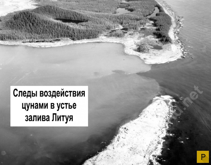
This catastrophe does not fit any of the previously described incidents on the sea coast. To date, the Lituya Bay megatsunami has become the most gigantic and destructive in the world. Eminent luminaries in the field of oceanology and seismology are still arguing about the possibility of a repetition of such a nightmare.
Lituya Bay is located in Alaska and extends inland for eleven kilometers, its maximum width does not exceed three kilometers. Two glaciers descend into the bay, which became the unwitting creators of a huge wave. The 1958 tsunami in Alaska was caused by an earthquake on July 9th. The power of the shocks exceeded eight points, which caused a huge landslide to descend into the waters of the bay. Scientists calculated that thirty million cubic meters of ice and stones fell into the water in a few seconds. Parallel to the landslide, an under-ice lake sank thirty meters, from which the released water masses rushed into the bay.

A huge wave rushed to the coast and circled the bay several times. The height of the tsunami wave reached five hundred meters, the raging element completely demolished the trees on the rocks along with the ground. At the moment, this wave is the highest in the history of mankind. The surprising fact is that only five people died as a result of a powerful tsunami. The fact is that there are no residential settlements in the bay; at the time the wave arrived in Lituya, there were only three fishing boats. One of them, together with the crew, immediately sank, and the other was raised by a wave to its maximum height and carried out into the ocean.
2004 Indian Ocean avalanche
The tsunami in Thailand in 2004 shocked all people on the planet. As a result of the destructive wave, more than two hundred thousand people died. The cause of the disaster was an earthquake in the Sumatra region on December 26, 2004. The tremors lasted no more than ten minutes and exceeded nine on the Richter scale.
A thirty-meter wave swept at great speed throughout the Indian Ocean and circled it, stopping near Peru. Almost all island states, including India, Indonesia, Sri Lanka and Somalia, suffered from the tsunami.
After killing several hundred thousand people, the 2004 Thailand tsunami left behind destroyed houses, hotels and several thousand local residents who died as a result of infections and poor-quality drinking water. At the moment, this tsunami is considered the largest in the twenty-first century.

Severo-Kurilsk: tsunami in the USSR
The list of "The biggest tsunamis in the world" should include the wave that hit the Kuriles in the middle of the last century. An earthquake in the Pacific Ocean caused a twenty-meter wave. The epicenter of the tremors of magnitude seven was located one hundred and thirty kilometers from the coast.
The first wave arrived in the city about an hour later, but most of the locals were in hiding on the high ground away from the city. No one warned them that a tsunami was a series of waves, so all the townspeople returned to their homes after the first one. A few hours later, the second and third waves hit Severo-Kurilsk. Their height reached eighteen meters, they almost completely destroyed the city. More than 2,000 people died as a result of the cataclysm.
Killer wave in Chile
In the second half of the last century, the inhabitants of Chile faced a terrifying tsunami, which killed more than three thousand people. The cause of the giant waves was the most powerful earthquake in the history of mankind, its magnitude exceeded nine and a half points.
A twenty-five-meter high wave covered Chile fifteen minutes after the first shocks. During the day, she covered several thousand kilometers, destroying the coast of Hawaii and Japan.

Despite the fact that humanity has been "familiar" with the tsunami for quite a long time, this natural phenomenon is still among the little-studied. Scientists have not learned how to predict the appearance of killer waves, therefore, most likely, in the future the list of their victims will be replenished with new deaths.
When I read about the height of the wave caused by the tsunami in 1958, I could not believe my eyes. Checked once, then twice. Everywhere is the same. No, probably, after all, they made a mistake with a comma, and everyone copies from each other. Maybe in units of measurement?
Well, how else, what do you think, maybe a wave from a tsunami 524 meters high? HALF A KILOMETER!
Now we find out what really happened there ...
Here is what an eyewitness writes:
“After the first push, I fell off the bed and looked towards the beginning of the bay, where the noise was coming from. The mountains trembled terribly, stones and avalanches rushed down. And the glacier in the north was especially striking, it is called the Lituya glacier. Usually, it is not visible from where I was at anchor. People shake their heads when I tell them that I saw him that night. I can't help it if they don't believe me. I know that the glacier is not visible from where I anchored in Anchorage Bay, but I also know that I saw it that night. The glacier rose into the air and moved forward, so that it became visible. He must have climbed several hundred feet. I'm not saying that he just hung in the air. But he was shaking and jumping around like crazy. Large pieces of ice fell from its surface into the water. The glacier was six miles from me, and I saw large pieces that fell off it like a huge dump truck. This went on for some time - it's hard to say how long - and then suddenly the glacier disappeared from view and a large wall of water rose above this place. The wave went in our direction, after which I was too busy to say what else was going on there.

On July 9, 1958, an unusually severe disaster occurred in Lituya Bay in southeast Alaska. In this bay, protruding into the land for more than 11 km, geologist D. Miller discovered a difference in the age of trees on the slope of the hills surrounding the bay. From annual tree rings, he calculated that over the past 100 years, waves with a maximum height of several hundred meters have arisen at least four times in the bay. Miller's conclusions were treated with great distrust. And so, on July 9, 1958, a strong earthquake occurred on the Fairweather fault to the north of the bay, which caused the destruction of buildings, the collapse of the coast, and the formation of numerous cracks. And a huge landslide on the mountainside above the bay caused a wave of record height (524 m), which swept at a speed of 160 km/h through a narrow, fjord-like bay.
Lituya is a fjord located on the Fairweather Fault in the northeastern part of the Gulf of Alaska. It is a T-shaped bay 14 kilometers long and up to three kilometers wide. The maximum depth is 220 m. The narrow entrance to the bay has a depth of only 10 m. Two glaciers descend into Lituya Bay, each of which is about 19 km long and up to 1.6 km wide. Over the century preceding the described events, waves over 50 meters high have already been observed in Lituye several times: in 1854, 1899 and 1936.
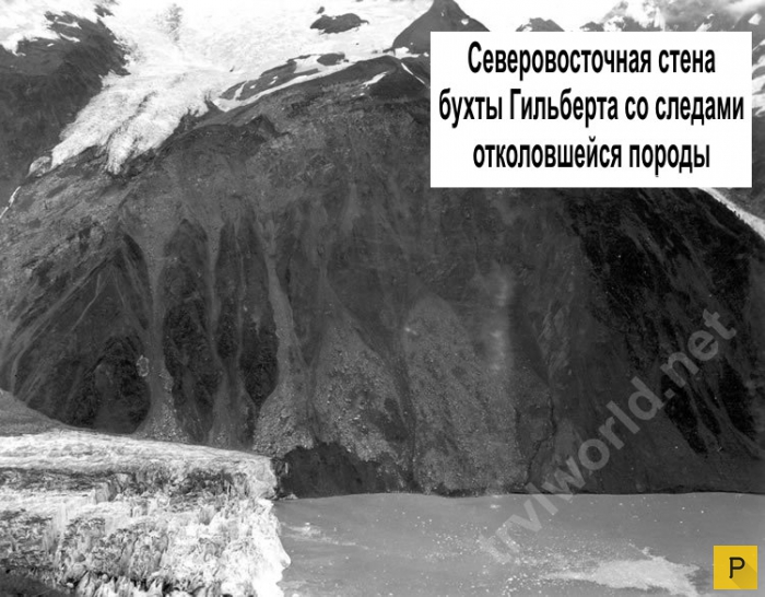
The 1958 earthquake caused a subaerial rockfall at the mouth of the Gilbert Glacier in Lituya Bay. As a result of this landslide, more than 30 million cubic meters of rock collapsed into the bay and led to the formation of a megatsunami. From this disaster, 5 people died: three on Hantaak Island and two more were washed away by a wave in the bay. In Yakutat, the only permanent settlement near the epicenter, infrastructure facilities were damaged: bridges, docks and oil pipelines.
After the earthquake, research was carried out on a subglacial lake located to the northwest of the bend of the Lituya glacier at the very beginning of the bay. It turned out that the lake dropped by 30 meters. This fact served as the basis for another hypothesis of the formation of a giant wave with a height of more than 500 meters. Probably, during the glacier retreat, a large volume of water entered the bay through an ice tunnel under the glacier. However, the runoff of water from the lake could not be the main cause of the megatsunami.

A huge mass of ice, stones and earth (about 300 million cubic meters in volume) rushed down from the glacier, exposing the mountain slopes. The earthquake destroyed numerous buildings, cracks formed in the ground, and the coast slipped. The moving mass collapsed on the northern part of the bay, filled it up, and then crawled onto the opposite slope of the mountain, tearing off the forest cover from it to a height of more than three hundred meters. The landslide generated a giant wave that literally carried the Lituya Bay towards the ocean. The wave was so great that it swept over the entire shallow at the mouth of the bay.
The eyewitnesses of the disaster were people on board the ships that anchored in the bay. From a terrible push, they were all thrown out of their beds. Jumping to their feet, they could not believe their eyes: the sea was heaving. “Giant landslides, raising clouds of dust and snow in their path, began to run along the slopes of the mountains. Soon their attention was attracted by an absolutely fantastic sight: the mass of ice of the Lituya glacier, located far to the north and usually hidden from view by a peak that rises at the entrance to the bay, seemed to rise above the mountains and then majestically collapsed into the waters of the inner bay. It all felt like some kind of nightmare. Before the eyes of the shocked people, a huge wave rose up, which swallowed the foot of the northern mountain. After that, she swept across the bay, ripping off trees from the slopes of the mountains; having fallen like a water mountain on the island of Cenotaphia ... rolled over the highest point of the island, which towered 50 m above sea level. All this mass suddenly plunged into the waters of a narrow bay, causing a huge wave, the height of which, obviously, reached 17-35 m. Its energy was so great that the wave rushed furiously across the bay, overflowing the slopes of the mountains. In the inner basin, the impacts of the wave on the shore were probably very strong. The slopes of the northern mountains, facing the bay, were bare: where a dense forest used to grow, there were now bare rocks; such a picture was observed at an altitude of up to 600 meters.
One longboat was raised high, easily carried across the shallows and thrown into the ocean. At that moment, when the longboat was moving across the shallows, the fishermen on it saw standing trees under them. The wave literally threw people across the island into the open sea. During a nightmarish ride on a giant wave, the boat pounded against trees and debris. The longboat sank, but the fishermen miraculously survived and were rescued two hours later. Of the other two launches, one safely withstood the wave, but the other sank, and the people on it went missing.
Miller found that the trees growing on the upper edge of the exposed area, just below 600 m above the bay, were bent and broken, their fallen trunks pointing towards the top of the mountain, but the roots were not uprooted from the soil. Something pushed those trees up. The tremendous force that did this could not have been anything other than the riding of a gigantic wave that swept over the mountain on that July evening in 1958.

Mr. Howard J. Ulrich, on his yacht called the Edri, entered the waters of Lituya Bay at about eight in the evening and anchored in a depth of nine meters in a small bay on the south coast. Howard says that suddenly the yacht began to sway violently. He ran out onto the deck and saw how in the northeastern part of the bay the rocks began to move due to the earthquake and a huge block of rock began to fall into the water. Approximately two and a half minutes after the earthquake, he heard a deafening sound from the destruction of the rock.
“We definitely saw that the wave went from the direction of Gilbert's Bay, just before the earthquake ended. But at first it was not a wave. At first it was more like an explosion, as if the glacier was breaking apart. The wave grew from the surface of the water, at first it was almost invisible, who would have thought that then the water would rise to a height of half a kilometer.
Ulrich said that he observed the whole process of the development of the wave, which reached their yacht in a very short time - something like two and a half or three minutes since it was first seen. “Since we did not want to lose the anchor, we completely etched the anchor chain (about 72 meters) and started the engine. Halfway between the northeastern edge of Lituya Bay and Cenotaf Island, a thirty-meter-high wall of water could be seen that stretched from one shore to the other. When the wave approached the northern part of the island, it split into two parts, but, having passed the southern part of the island, the wave became one again. It was smooth, only there was a small scallop on top. When this water mountain approached our yacht, its front was quite steep and its height was from 15 to 20 meters. Before the wave came to the place where our yacht was, we did not feel any lowering of the water or other changes, except for a slight vibration that was transmitted through the water from the tectonic processes that began to act during the earthquake. As soon as the wave approached us and began to lift our yacht, the anchor chain crackled violently. The yacht was carried towards the south coast and then, on the return course of the wave, towards the center of the bay. The top of the wave was not very wide, from 7 to 15 meters, and the back front was less steep than the front.
As the giant wave swept past us, the surface of the water returned to its normal level, but we could observe a lot of turbulent eddies around the yacht, as well as chaotic waves of six meters in height, which moved from one side of the bay to the other. These waves did not form any noticeable movement of water from the mouth of the bay to its northeastern part and back.
After 25-30 minutes the surface of the bay calmed down. Near the banks one could see many logs, branches and uprooted trees. All this rubbish slowly drifted towards the center of the Lituya Bay and towards its mouth. In fact, during the entire incident, Ulrich did not lose control of the yacht. When the Edri approached the mouth of the bay at 11 pm, a normal current could be observed there, which is usually caused by the daily low tide of ocean water.

Other eyewitnesses to the disaster, the Swanson couple on a yacht called the Badger, entered Lituya Bay around nine in the evening. First, their ship approached the island of Cenotaf, and then returned to Anchorage Bay on the northern shore of the bay, not far from its mouth (see map). The Swensons anchored at a depth of about seven meters and went to sleep. William Swanson's sleep was interrupted due to the strong vibration of the yacht's hull. He ran to the control room and began to time what was happening. A little over a minute from when William first felt the vibration, and probably just before the end of the quake, he looked towards the northeast part of the bay, which was visible against the backdrop of the island of Cenotaf. The traveler saw something that he first took for the Lituya glacier, which rose into the air and began to move towards the observer. “It seemed that this mass was solid, but it jumped and swayed. In front of this block, large pieces of ice constantly fell into the water. After a short time, “the glacier disappeared from sight, and instead a large wave appeared in that place and went in the direction of the La Gaussy spit, just where our yacht was anchored.” In addition, Swenson drew attention to the fact that the wave flooded the coast at a very noticeable height.
When the wave passed the island of Cenotaf, its height was about 15 meters in the center of the bay and gradually decreased near the coast. She passed the island about two and a half minutes after she could first be seen, and reached the Badger yacht after another eleven and a half minutes (approximately). Before the wave arrived, William, like Howard Ulrich, did not notice any lowering of the water level or any turbulent phenomena.
The Badger, which was still at anchor, was lifted by a wave and carried towards the La Gaussy spit. At the same time, the stern of the yacht was below the crest of the wave, so that the position of the vessel resembled a surfboard. Svenson looked at that moment at the place where the trees growing on the La Gaussy spit should have been visible. At that moment they were hidden by water. William noted that above the tops of the trees there was a layer of water equal to about twice the length of his yacht, about 25 meters. Having passed the La Gaussy spit, the wave very quickly began to decline.
In the place where Swenson's yacht stood, the water level began to drop, and the ship hit the bottom of the bay, remaining afloat close to the shore. 3-4 minutes after the impact, Swenson saw that the water continued to flow over the La Gaussi spit, carrying logs and other debris of forest vegetation. He wasn't sure it wasn't a second wave that could have carried the yacht across the spit into the Gulf of Alaska. So the Swensons left their yacht, moving onto a small boat, from which they were picked up by a fishing boat a couple of hours later.
There was also a third vessel in Lituya Bay at the time of the incident. It was anchored at the entrance to the bay and was sunk by a huge wave. None of the people on board survived, and two are believed to have died.

What happened on July 9, 1958? That evening, a huge rock fell into the water from a steep cliff overlooking the northeastern shore of Gilbert's Bay. The collapse area is marked in red on the map. The blow of an incredible mass of stones from a very high altitude caused an unprecedented tsunami, which wiped out all living things from the face of the earth that was along the coast of the Lituya Bay up to the La Gaussi spit. After the wave passed along both sides of the bay, not only vegetation, but even soil was left; there was bare rock on the surface of the shore. The area of damage is shown on the map in yellow.

The numbers along the coast of the bay indicate the height above sea level of the edge of the damaged land area and approximately correspond to the height of the wave that passed here.
The most common cause of waves in the oceans and seas is the wind: air gusts move the surface layers of water at a certain speed. Thus, the wind can disperse a wave at a speed of 95 km / h, the raised water column can reach 300 meters in length. Such waves are able to overcome gigantic distances, but, as a rule, wave energy is extinguished in the ocean, being consumed long before land. In the case when the wind subsides, the disturbances in the ocean become smaller and smooth out.
Patterns of wave formation
Wave length and height depend not only on wind speed. The influence and duration of the wind impact is great, and it also matters what area of the territory was covered by it. There is a regular correspondence: the maximum wave height is 1/7 of its length. For example, a breeze with a force above the average forms waves whose height reaches 3 meters, a hurricane, which has a vast area, raises waves up to about 20 meters.
Big wave formation
In 1933, the sailors of the American ship Ramapo in the South African Agulhas noted the highest normal wave - it reached a height of 34 m. Waves of a similar height are popularly called "killer waves", since even a large ship can easily fall through and get lost in the distances between their crests. Theoretically, the height of such ordinary waves can reach 60 m, but in practice, such waves have never been recorded.
In addition to the normal, that is, the wind origin of waves, other causes of wave generation are also known:
- earthquake
- eruption
- large meteorites falling into the ocean
- landslides leading to a sharp change in the line of the coast
- nuclear weapons testing or other human activity
Tsunami
Tsunamis have the biggest waves. In fact, this is a serial wave caused by a certain impulse of enormous power. Tsunami waves are quite long, dips between peaks can reach more than 10 km. For this reason, a tsunami in the open ocean is not a big danger, since the wave height rarely reaches 20 cm, only in some (record) cases they can reach 1.5 m. But the speed of the tsunami develops grandiose - waves propagate at a speed of 800 km / h. In the open sea, such waves are almost impossible to notice from a ship. Tsunami waves acquire their monstrous strength as they approach the coastline. Reflecting from the shore, the waves are compressed in length, and their destructive energy does not disappear anywhere. As a result, the wave amplitude increases - their height. Of course, such waves are much more dangerous than wind waves, since they reach a much greater height.
The causes of the most terrifying tsunamis are significant disturbances in the topography of the ocean floor. These can be tectonic shifts or faults, in the event of which a billion tons of water moves at the speed of a jet aircraft over vast distances (as many as tens of thousands of kilometers). And it happens abruptly, immediately. A catastrophe is inevitable when a multibillion-dollar mass of water reaches the shore. Then the colossal energy of the waves is first directed to increase the amplitude, and then it falls on the coast with the entire powerful wall of water.
 Tsunami in Sumatra in 2004
 Bays with high shores are most often subject to dangerous tsunamis. Such places are real traps for serial waves. What is characteristic and at the same time scary is that a tsunami almost always strikes suddenly, visually the sea can be the same as during low tides, high tides or an ordinary storm, so people do not even think about timely evacuation. Unfortunately, special warning systems for the approach of giant waves have not been developed everywhere.
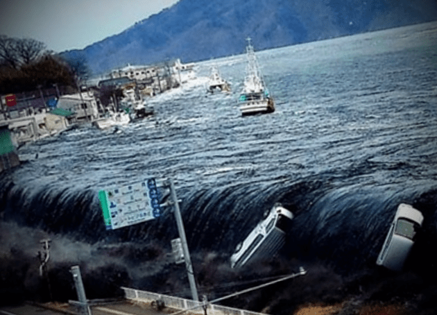
Tsunami risk zones are also seismically active territories. The word "tsunami" itself is of Japanese origin, since earthquakes are very frequent here and waves of various scales and sizes constantly attack the islands. There are also real giants among them, it is they who lead to human casualties. The earthquake of 2011, which occurred in the east of Honshu, gave rise to a powerful tsunami up to 40 m high. Japan has not yet known such earthquakes. The catastrophe had horrific consequences: the monstrous power of the waves dealt severe blows along the entire eastern coast of the island, taking away the lives of over 15 thousand people along with the earthquake, several thousand people are considered missing to this day.
A large-scale disaster on the islands of Java and Sumatra in 2004 turned into a tsunami, which was generated by a strong earthquake in the Indian Ocean. According to various sources, from 200 to 300 thousand people died - this is 1/3 million. To date, the tsunami in the Indian Ocean is recognized as the most destructive in the world.
The record holder for the amplitude of the waves was tsunami "Lituya" that happened in 1958. It swept across Lituya Bay in Alaska at a speed of 160 km/h. The cause of the world's highest tsunami was a gigantic landslide. The wave height reached 524 m.
At the end of December 2004, one of the strongest earthquakes in the last half century occurred near the island of Sumatra, located in the Indian Ocean. Its consequences turned out to be catastrophic: due to the displacement of the lithospheric plates, a huge fault was formed, and a large amount of water rose from the ocean floor, which, at a speed reaching one kilometer per hour, began to move rapidly throughout the Indian Ocean.
As a result, thirteen countries were affected, about a million people were left without a “roof over their heads”, and more than two hundred thousand died or went missing. This disaster turned out to be the worst in the history of mankind.
Tsunamis are long and high waves that appear as a result of a sharp displacement of the lithospheric plates of the ocean floor during underwater or coastal earthquakes (the length of the shaft is from 150 to 300 km). Unlike ordinary waves, which appear as a result of a strong wind (for example, a storm) affecting the water surface, a tsunami wave affects water from the bottom to the surface of the ocean, which is why even low-lying water can often lead to disasters.
Interestingly, these waves are not dangerous for ships in the ocean at this time: most of the agitated water is in its bowels, the depth of which is several kilometers - and therefore the height of the waves above the water surface is from 0.1 to 5 meters. Approaching the coast, the back of the wave catches up with the front, which at this time slows down slightly, grows to a height of 10 to 50 meters (the deeper the ocean, the larger the shaft) and a crest appears on it.
It should be taken into account that the impending shaft develops the highest speed in the Pacific Ocean (it ranges from 650 to 800 km/h). As for the average speed of most waves, it ranges from 400 to 500 km / h, but cases have been recorded when they accelerated to a speed of a thousand kilometers (the speed usually increases after the wave passes over a deep trench).


Before crashing on the coast, the water suddenly and quickly moves away from the coastline, exposing the bottom (the further it retreated, the higher the wave will be). If people do not know about the approaching elements, instead of moving as far as possible from the coast, on the contrary, they run to collect shells or pick up fish that did not have time to go to sea. And just a few minutes later, a wave that arrived here at great speed does not leave them the slightest chance of salvation.
It must be borne in mind that if a wave rolls on the coast from the opposite side of the ocean, then the water does not always recede.
Ultimately, a huge mass of water floods the entire coastal line and goes inland to a distance of 2 to 4 km, destroying buildings, roads, piers and leading to the death of people and animals. In front of the shaft, clearing the way for water, there is always an air shock wave, which literally blows up buildings and structures that are in its path.
It is interesting that this deadly natural phenomenon consists of several waves, and the first wave is far from the largest: it only wets the coast, reducing the resistance for the waves following it, which often do not come immediately, and at intervals of two to three hours. The fatal mistake of people is their return to the shore after the departure of the first attack of the elements.
Reasons for education
One of the main reasons for the displacement of lithospheric plates (in 85% of cases) are underwater earthquakes, during which one part of the bottom rises and the other falls. As a result, the ocean surface begins to oscillate vertically, trying to return to the initial level, forming waves. It is worth noting that underwater earthquakes do not always lead to the formation of a tsunami: only those where the source is located at a small distance from the ocean floor, and the shaking was at least seven points.
The reasons for the formation of a tsunami are quite different. The main ones include underwater landslides, which, depending on the steepness of the continental slope, are able to overcome huge distances - from 4 to 11 km strictly vertically (depending on the depth of the ocean or gorge) and up to 2.5 km - if the surface is slightly inclined.


Large waves can cause huge objects that have fallen into the water - rocks or blocks of ice. Thus, the largest tsunami in the world, whose height exceeded five hundred meters, was recorded in Alaska, in the state of Lituya, when, as a result of a strong earthquake, a landslide descended from the mountains - and 30 million cubic meters of stones and ice fell into the bay.
Volcanic eruptions (about 5%) can also be attributed to the main causes of tsunamis. During strong volcanic explosions, waves are formed, and water instantly fills the vacant space inside the volcano, as a result of which a huge shaft is formed and begins its journey.
For example, during the eruption of the Indonesian volcano Krakatoa at the end of the XIX century. "killer wave" destroyed about 5 thousand ships and caused the death of 36 thousand people.
In addition to the above, experts identify two more possible causes of a tsunami. First of all, it is a human activity. So, for example, in the middle of the last century, Americans made an underwater atomic explosion at a depth of sixty meters, causing a wave about 29 meters high, however, it did not last long and fell, breaking 300 meters as much as possible.
Another reason for the formation of a tsunami is the fall into the ocean of meteorites with a diameter of more than 1 km (the impact of which is strong enough to cause a natural disaster). According to one version of scientists, several thousand years ago, it was meteorites that caused the strongest waves that caused the largest climatic disasters in the history of our planet.
Classification
When classifying tsunamis, scientists take into account a sufficient number of factors of their occurrence, including meteorological disasters, explosions, and even ebb and flow, while the list includes low wave surges about 10 cm high.
Shaft strength
The strength of the shaft is measured, taking into account its maximum height, as well as how catastrophic the consequences it caused, and, according to the international IIDA scale, 15 categories are distinguished, from -5 to +10 (the more victims, the higher the category).
By intensity
According to the intensity of the “killer wave”, they are divided into six points, which make it possible to characterize the consequences of the elements:
- Waves with a category of one point are so small that they are recorded only by instruments (most do not even know about their presence).
- Double-point waves are capable of slightly flooding the coast, therefore only specialists can distinguish them from fluctuations of ordinary waves.
- The waves, which are classified as three-point, are strong enough to throw small boats onto the coast.
- Four-point waves can not only wash large sea vessels ashore, but also throw them ashore.
- Five-point waves are already acquiring the scale of a catastrophe. They are able to destroy low buildings, wooden buildings, and lead to human casualties.
- As for the six-point waves, the waves that have washed over the coast completely devastate it along with the adjacent lands.
By the number of victims
According to the number of deaths, five groups of this dangerous phenomenon are distinguished. The first includes situations where deaths were not recorded. To the second - waves that resulted in the death of up to fifty people. Shafts belonging to the third category cause the death of fifty to one hundred people. The fourth category includes "killer waves" that killed from a hundred to a thousand people.


The consequences of the tsunami, belonging to the fifth category, are catastrophic, since they entail the death of more than a thousand people. Typically, such disasters are characteristic of the deepest ocean in the world, the Pacific, but often occur in other parts of the planet. This applies to the disasters of 2004 near Indonesia and 2011 in Japan (25,000 deaths). “Killer waves” were also recorded in history in Europe, for example, in the middle of the 18th century, a thirty-meter shaft collapsed on the coast of Portugal (during this disaster, from 30 to 60 thousand people died).
Economic damage
As for the economic damage, it is measured in US dollars and calculated taking into account the costs that must be allocated for the restoration of the destroyed infrastructure (lost property and destroyed houses are not taken into account, because they are related to the country's social expenditures).
According to the size of losses, economists distinguish five groups. The first category includes waves that did not cause much harm, the second - with losses up to $ 1 million, the third - up to $ 5 million, the fourth - up to $ 25 million.
The damage from the waves, related to the fifth group, exceeds 25 million. For example, the losses from two major natural disasters in 2004 near Indonesia and in 2011 in Japan amounted to about $250 billion. The environmental factor should also be taken into account, since the waves that caused the death of 25 thousand people damaged a nuclear power plant in Japan, causing an accident.
Natural disaster identification systems
Unfortunately, "killer waves" often appear so unexpectedly and move at such a high speed that it is extremely difficult to determine their appearance, and therefore seismologists often fail to cope with the task assigned to them.


Basically, disaster warning systems are built on the processing of seismic data: if there is a suspicion that an earthquake will have a magnitude of more than seven points, and its source will be on the ocean (sea) floor, then all countries that are at risk receive warnings of the approach of huge waves.
Unfortunately, the disaster of 2004 happened because almost all the neighboring countries did not have an identification system. Despite the fact that about seven hours passed between the earthquake and the surge, the population was not warned about the approaching disaster.
To determine the presence of dangerous waves in the open ocean, scientists use special hydrostatic pressure sensors that transmit data to the satellite, which allows you to fairly accurately determine the time of their arrival at a particular point.
How to survive during the elements
If it so happens that you find yourself in an area where there is a high probability of deadly waves, you should definitely not forget to follow the forecasts of seismologists and remember all the warning signals of an approaching disaster. It is also necessary to know the boundaries of the most dangerous zones and the shortest roads by which you can leave the dangerous area.
If you hear a signal warning of approaching water, you should immediately leave the danger area. Experts will not be able to say exactly how much time there is for evacuation: maybe a couple of minutes or several hours. If you do not have time to leave the area and live in a multi-storey building, then you need to go up to the top floors, closing all windows and doors.
But if you are in a one- or two-story house, you must immediately leave it and run to a tall building or climb any hill (in extreme cases, you can climb a tree and cling to it tightly). If it so happened that you did not have time to leave a dangerous place and ended up in the water, you need to try to free yourself from shoes and wet clothes and try to cling to floating objects.
When the first wave subsides, it is necessary to leave the dangerous area, since the next one will most likely come after it. You can return only when there are no waves for about three to four hours. Once at home, check walls and ceilings for cracks, gas leaks, and electrical conditions.
Where do giant waves come from?
What causes the appearance of most waves in the oceans and seas, about the energy of the waves and about the most gigantic waves.
The main reason for the appearance of ocean waves is the influence of winds on the water surface. The speed of some waves can develop and even exceed 95 km per hour. Ridge from ridge can be separated by 300 meters. They travel great distances across the surface of the ocean. Most of their energy is used up before they reach land, perhaps bypassing the deepest place in the world- The Mariana Trench. And yes, they are getting smaller. And if the wind calms down, then the waves become calmer and smoother.
If there is a strong breeze in the ocean, then the height of the waves usually reaches 3 meters. If the wind starts to become stormy, then they can become 6 m. In a strong gale, their height can already be more than 9 m and they become steep, with abundant spray.
During a storm, when visibility is difficult in the ocean, the height of the waves exceeds 12 meters. But during a severe storm, when the sea is completely covered with foam and even small ships, yachts or ships (and not just fish, even the biggest fish) can simply get lost between 14 waves.
The beat of the waves
Large waves gradually wash away the coast. Small waves can slowly level the beach with sediment. Waves hit the shores at a certain angle, therefore, sediment washed away in one place will be carried out and deposited in another.
During the strongest hurricanes or storms, such changes can occur that huge stretches of the coast can suddenly transform significantly.
And not only the coast. Once upon a time, in 1755, very far from us, waves of 30 meters high blew Lisbon off the face of the earth, submerging the city's buildings under tons of water, turning them into ruins and killing more than half a million people. And it happened on a big Catholic holiday - All Saints' Day.
killer waves
The largest waves are usually observed along the Needle Current (or Agulhas Current), off the coast of South Africa. Here it was also noted highest wave in the ocean. Its height was 34 m. In general, the largest wave ever seen was recorded by Lieutenant Frederick Margo on a ship on its way from Manila to San Diego. It was February 7, 1933. The height of that wave was also about 34 meters. Sailors gave the nickname "killer waves" to such waves. As a rule, an unusually high wave is always preceded by the same deep depression (or dip). It is known that a large number of ships disappeared in such hollows-failures. By the way, the waves that form during the tides are not connected with the tides. They are caused by an underwater earthquake or volcanic eruption on the sea or ocean floor, which creates the movement of huge masses of water and, as a result, large waves.