Volga river the largest and deepest river in Europe. The ancient name of Ra (lat. rha) the less old name of Vloga is Itil, the river received in the Middle Ages. It is the largest river that does not flow into the sea. 2/3 of Russia's population lives in the Volga basin. Its source is located on the Valdai Upland at an altitude of 256 m above sea level. And at the mouth, on the northern coast of the Caspian Sea, in its delta, there are the largest lotus fields in the world, covering hundreds of hectares.
Here is what Alexander Dumas wrote about the Volga: “Each country has its own national river. Russia has the Volga - the largest river in Europe, the queen of our rivers - and I hastened to bow to Her Majesty the Volga River!
River length: 3,530 kilometers.
Watershed area: 1,360 thousand sq. km.
highest point: Mount Bezymyannaya, 381.2 m (Zhiguli Mountains).
Channel width: up to 2500 m.
Slope and fall: 256 m and 0.07 m/km (or ppm), respectively.
Average current speed: less than 1 m/s.
River depth: the average depth is 8 - 11 meters, in some areas 15 - 18 meters.
delta area: 19,000 sq. km.
Average annual flow:>38 km3
Where does it run: The Volga originates in one of the most elevated parts of the Valdai plateau in the Tver region. It flows from a small spring in the middle of swampy lakes, not far from the village of Volgoverkhovye. The source coordinates are 57°15' north latitude and 2°10' east longitude. The height of the source above sea level is 228 meters. The Volga flows through the entire central lowland of European Russia. The river bed is meandering, but the general direction of flow is east. At Kazan, approaching almost the very foothills of the Urals, the river turns sharply to the south. The Volga becomes a truly mighty river only after the Kama flows into it. At Samara, the Volga breaks through a whole chain of hills and forms the so-called Samara bow. Not far from Volgograd, the Volga approaches another mighty river - the Don. Here the river again makes a turn and flows in a southeasterly direction until it flows into the Caspian Sea. At the mouth of the Volga forms a vast delta and is divided into many branches.
River mode, food: Most of the water comes from groundwater, and to a lesser extent, food comes from precipitation.
Freezing: The Volga is covered with ice in late October - early November and remains under it until the end of April - mid-March.
Tributaries: About 200 tributaries flow into the Volga. The largest of which are Kama and Oka, as well as smaller streams such as: Unzha, Kerzhenets, Sura, Tvertsa, Medveditsa and others.
It has not yet been decided whether it is possible to consider that the Kama flows into the Volga. Since, according to the rules of hydrography, it turns out that everything is exactly the opposite, and it is the Volga that should flow into the Kama. Since the Kama is older by origin, it has a larger basin and tributaries too.
The direction of flow in most of the river is from north to south. Between the tributaries of the Oka and Kama, the Volga has a predominantly latitudinal course.
For centuries, the Volga has served people as a source of clean water, fish, energy, and a transport artery. But today it is in danger, human activity pollutes it and threatens with a catastrophe.
The favorable geographical position of the river and human activities in the construction of canals have turned the Volga into the largest transport artery. In addition to the Caspian Sea, it is connected to 4 more seas: the Baltic, White, Black and Azov. Its waters irrigate fields, and its hydroelectric power plants provide electricity to entire cities and major enterprises. However, intensive economic use has led to the pollution of the Volga with industrial and agricultural waste. Huge areas were flooded during the construction of dams.
Ecologists say that the ecological situation is critical and the river's ability to self-purify has been exhausted. Blue-green algae capture more and more territories every year, fish mutations are observed. The Volga is called one of the dirtiest rivers in the world. Ecologists may like to dramatize, but if it's too late, it will be much worse. In any case, there are problems. Therefore, the protection of the river is very important now.
The Volga River is the largest river in Europe, the most abundant in Russia. This is the longest river in the world that flows into the inland water - the Caspian Sea.
The river basin occupies an area the size of half of Europe.
The Volga River (a brief description is given below) has more than one and a half hundred tributaries - this is one of the record figures on the planet. On average, it takes 37 days for water to pass from source to mouth, since the current speed is about 4 km per hour. The Volga is one of the few rivers that has its own holiday - in Russia, May 20 is considered to be Volga Day.
The Volga River: a brief description of the geographical location
The Volga flows through the territory of Russia, only a small branch of the Kigach goes east to the Atyrau region of the Republic of Kazakhstan. The Volga River (a brief description for children will go below) begins in the Tver region near the village, which is called Volgoverkhovye.

Here, its source is a small stream, which after a few kilometers crosses the lakes - first Small, and then Big Verkhity, giving strength to the great river. About a third is washed by the waters of the Volga basin. The Volga and its tributaries flow through the territory of thirty administrative regions of Russia and one region of Kazakhstan.

The mouth of the river is located in the Astrakhan region and is the largest delta in Europe of the many branches that flow into the Caspian Sea.
Historical information
The Volga, as an important trade artery of Eurasia, has been known to mankind for a long time. Having a great length and favorable geographical position, it was especially popular with merchants. Back in the 5th century BC, Herodotus, the ancient Greek philosopher, mentioned it in his treatise on the campaign of King Darius against the Scythian tribes. He called the Volga Oar. In the ancient Arabic chronicles, she is listed as Itil.
By the 10th century AD, a well-known link connecting Scandinavia with the Arab countries had formed. Large trading centers were formed on the banks of the great river: Khazar Itil and Bulgar, Russian Murom, Novgorod, Suzdal. In the 16-18 centuries, such large cities as Saratov, Samara, Volgograd appeared on the map of the Volga region. Here, in the trans-Volga steppes, the rebellious Cossacks and peasants hid. Giving a brief description of the Volga, it should be noted that at all times it performed an important economic function - it connected ports within the country and was a highway for connecting different states. In the middle of the 20th century, after its formation, the political function of the river also increased - access to the Azov and Black Seas, therefore, to the World Ocean.
The nature of the Volga basin
The Volga River is rich in natural resources. A brief description of the main plant and animal species is given below. There are four types of plants in the water: algae, aquatic submerged, aquatic with floating leaves, amphibians. A wide variety of herbs (wormwood, sedge, mint, marshmallow, spurge) grows in coastal areas, as it is covered with extensive meadows. An abundance of blackberries and reeds. For hundreds of kilometers along the Volga there are forest belts with birches, ash trees, willows, poplars. This is a brief description of the Volga River, its flora.

The fauna of the river is also diverse. About fifty species of fish live in the water, including sturgeon, beluga, stellate sturgeon. Coastal expanses are densely populated with birds and animals. Special nature in the Volga Delta, where the unique Astrakhan Nature Reserve is located. It is home to many insects, birds, mammals and a wide variety of plants. Some representatives of the fauna that exist in the reserve are listed in the Red Book: mute swan, pelican, white-tailed eagle, seal.
Large cities of the Volga region
The Volga region has an advantageous position both geographically and economically. Nearby are the developed regions of the Urals, Central Russia and Kazakhstan. It supplies settlements with water, energy, and the Volga River is the highway. A brief description of the most striking cities is given below. Many large and small cities are located on the banks of the Volga, with their own unique sights and amazing history. The largest are Kazan, Samara, Volgograd.
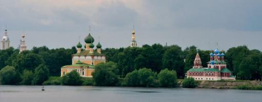
Kazan is a beautiful and ancient city included in the list of UNESCO World Heritage Cities. From the side of the Kazanka River - the left tributary of the Volga - the complex of the Kazan Kremlin is visible: the Annunciation Cathedral of the 16th century, the Kul Sharif mosque, the leaning Syuyumbike tower. The Kremlin is the main attraction of the city.
Samara is also a city located at the meeting point of three rivers - Samara, Soka and Volga. The main attractions are the bell tower of the Iversky convent, the historical center of the city.
The Hero City of Volgograd is one of the most beautiful settlements in Russia. Of the many cultural and historical sights of the city, it is necessary to note Mamaev Kurgan, located on the banks of the Volga, the Kazan Cathedral, the central Embankment.
On the banks of the Volga, there are also smaller original cities and towns with their own historical heritage and cultural monuments.
The Volga is one of the most important rivers in the world. It carries its waters through the European part of Russia and flows into the Caspian Sea. The industrial significance of the river is great, 8 hydroelectric power stations have been built on it, navigation and fishing are well developed. In the 1980s, a bridge was built across the Volga, which is considered the longest in Russia. Its total length from source to mouth is about 3600 km. But due to the fact that it is not customary to take into account those places that relate to reservoirs, the official length of the Volga River is 3530 km. Among all the water streams in Europe, it is the longest. On it are located such large cities as Volgograd, Kazan. That part of Russia, which is adjacent to the central artery of the country, is called the Volga region. A little more than 1 million km 2 is the river basin. Volgaz occupies a third of the European part of the Russian Federation.
Briefly about the river
The Volga is fed by snow, ground and rain waters. It is characterized by spring floods and autumn floods, as well as low water in summer and winter.
The source and mouth of which are covered with ice almost simultaneously, in October-November, and in March-April it begins to thaw.
Previously, back in ancient times, it was called Ra. Already in the Middle Ages there were references to the Volga under the name of Itil. The current name of the water stream comes from the word in the Proto-Slavic language, which is translated into Russian as “moisture”. There are also other versions of the origin of the name of the Volga, but so far it is impossible to confirm or refute them.
The source of the Volga
The Volga, whose source originates in the Tver region, begins at an altitude of 230 m. In the village of Volgoverkhovye there are several springs that were combined into a reservoir. One of them is the beginning of the river. In its upper course, it flows through small lakes, and after a few meters it passes through the Upper Volga (Peno, Vselug, Volgo and Sterzh), currently united in a reservoir.
A tiny swamp, which hardly attracts tourists with its appearance, is the source of the Volga. A map, even the most accurate, will not have specific data on the beginning of the water flow.

Mouth of the Volga
The mouth of the Volga is the Caspian Sea. It is divided into hundreds of branches, due to which a wide delta is formed, the area of \u200b\u200bwhich is about 19,000 km 2. Due to the large amount of water resources, this area is the richest in plants and animals. The fact that the mouth of the river ranks first in the world in terms of the number of sturgeon already speaks volumes. This river has a sufficient influence on climatic conditions, which have a beneficial effect on the flora and fauna, as well as on humans. The nature of this area fascinates and helps to have a good time. Fishing here is best from April to November. The weather and the number of fish species will never allow you to return empty-handed.

Vegetable world
The following types of plants grow in the waters of the Volga:
- amphibians (susak, reed, cattail, lotus);
- water immersed (naiad, hornwort, elodea, buttercup);
- aquatic with floating leaves (water lily, duckweed, pondweed, walnut);
- algae (hari, cladophora, hara).
The largest number of plants is represented at the mouth of the Volga. The most common are sedge, wormwood, pondweed, spurge, saltwort, astragalus. Wormwood, sorrel, reed grass and bedstraw grow in large quantities in the meadows.
The delta of the river called the Volga, the source of which is also not very rich in plants, has 500 different species. Sedge, spurge, marshmallow, wormwood and mint are not uncommon here. You can find thickets of blackberries and reeds. Meadows grow on the banks of the water stream. The forest is located in stripes. The most common trees are willows, ash and poplars.

Animal world
The Volga is rich in fish. It is inhabited by many aquatic animals that differ from each other in the way of existence. In total, there are about 70 species, of which 40 are commercial. One of the smallest fish in the pool is the puhead, whose length does not exceed 3 cm. It can even be confused with a tadpole. But the largest is the beluga. Its dimensions can reach 4 m. It is a legendary fish: it can live up to 100 years and weigh more than 1 ton. The most important are roach, catfish, pike, sterlet, carp, pike perch, sturgeon, bream. Such wealth not only provides products to nearby areas, but is also successfully exported to other countries.
Sterlet, pike, bream, carp, catfish, ruff, perch, burbot, asp - all these representatives of fish live in the introductory stream, and the Volga River is considered to be their permanent place of residence. Istok, unfortunately, cannot boast of such a rich diversity. In places where the water flow is calm and has a shallow depth, the southern stickleback lives - the only representative of sticklebacks. And in those areas where the Volga has the most vegetation, you can meet carp, which prefers quiet waters. Stellate sturgeon, herring, sturgeon, lamprey, beluga enter the river from the Caspian Sea. Since ancient times, the river has been considered the best for fishing.
You can also meet frogs, birds, insects and snakes. Dalmatian pelicans, pheasants, egrets, swans and white-tailed eagles are very often located on the banks. All these representatives are quite rare and are listed in the Red Book. There are many protected areas on the banks of the Volga, they help protect against extinction. Geese, ducks, teals and mallards nest here. Wild boars live in the nearby steppes, and saigas live in the nearby steppes. Very often on the seashore you can meet which are quite freely located near the water.

Significance of the Volga for Russia
The Volga, whose source is located in a village in the Tver region, flows throughout Russia. With its waterway, the river connects with the Baltic, Azov, Black and White seas, as well as the Tikhvin and Vyshnevolotsk systems. Large forests can be found in the Volga basin, as well as rich adjacent fields sown with various industrial and grain crops. The lands in these areas are fertile, which contributed to the development of horticulture and melon growing. It should be clarified that there are gas and oil deposits in the Volga-Ural zone, and salt deposits near Solikamsk and the Volga region.

It is impossible to argue with the fact that the Volga has a long and rich history. She is a participant in many important political events. And it also plays a huge economic role, being the main water artery of Russia, thereby uniting several regions into one. It has administrative and industrial centers, several millionaire cities. That is why this water stream is called the great Russian river.
Provided her with a significant role in the development of trade and the formation of large cities of the Slavic tribes. The Volga is the largest river in Europe. Even today it remains an important source of fresh water and electricity, a transport highway, and also attracts a large number of vacationers and tourists to its shores. Where is it located and what are its features? This will be discussed below.
Volga: geographical location
The river adorns the European part of our country. A small branch of the main channel flows through the territory of Kazakhstan. The source of the Volga is located on the Valdai Upland (229 meters above sea level). As is commonly believed, the mighty river begins near the village of Volgoverkhovye, Tver Region. The Volga basin occupies about a third of the European territory of Russia. It extends from the Valdai and Central Russian uplands up to the Urals.
The Volga is considered the largest river in the world that does not flow into the ocean. It carries its waters to the Caspian Sea, to the basin of which it belongs. The length of the river is 3530 km, the total fall is 256 m. The Volga basin covers an area of over a million square kilometers.
It is customary to divide the Great River into three parts: the upper (from the source to the mouth of the Oka), the middle (from the mouth of the Oka to the confluence of the Kama), and the lower (from the mouth of the Kama to the Caspian Sea).
Source
The river originates from a spring flowing from a swamp near the village of Volgoverkhovye. A temple was built nearby. The very source of the Volga is located under the floor of a small wooden chapel on stilts. It is equipped with a special window through which it is allowed to scoop up and drink water.
Approximately three kilometers from the source, the Volga flows alternately into two lakes: first into the Small Verkhity, and then into the Bolshaya Verkhity. Further, its path runs through the Upper Volga reservoir. The first large lake related to it is Sterzh. The Volga invades its waters with great force, swiftly, without mixing, overcomes them. It is said that on sunny days you can see the river flowing through the lake.
Upper Volga
Before the creation of reservoirs, the length of the river was longer and amounted to 3690 km. The first dam along the river is located after the Upper Volga lakes (Sterzh, Vselug, Peno, Volgo). It was built in 1843. There are several reservoirs on the Upper Volga today: Ivankovskoye (also referred to as a hydroelectric power station near the city of Dubna), Uglichskoye, Rybinskoye, Gorkovskoye (located near Gorodets, above Nizhny Novgorod).
The first major settlement from the source of the river is Rzhev. On the Upper Volga there are such ancient cities as Kostroma, Tver, Uglich and Yaroslavl. It flows through a picturesque area, now spreading widely, then narrowing between steep banks.
The main tributaries of the river in this segment are: Selizharovka, Darkness, Kotorosl, Tvertsa, Mologa, Sheksna, Unzha.
Middle Volga
After the confluence of the Oka, the river flows at the right edge of the Volga Upland. Here it becomes noticeably more full-flowing. The right bank of the Volga is high, while the left bank is low.
Near the city of Cheboksary there is a hydroelectric power station with a dam, above which there is a reservoir.
The main tributaries of the river in this segment are: Oka, Sura, Vetluga, Sviyaga.
Lower Volga

The river acquires its full power and strength after the confluence of the Kama. On this segment, it flows along the Volga Upland. Going around the Zhiguli Mountains, the Volga forms the Samara bow. Slightly higher than it is the Kuibyshev reservoir (adjacent to it is the Saratov hydroelectric power station. Near Balakovo, on the river, the river approaches the Don. A little higher than the city, the left arm, Akhtuba, separates from it. the so-called Volga-Akhtuba floodplain, consisting of a large number of channels.
Not far from Volgograd, on the section of the river between the city and the beginning of Akhtuba, there is the Volzhskaya hydroelectric power station and
The tributaries in this section of the river are quite small. These are Sok, Samara, Big Irgiz, Eruslan.
Mouth of the Volga
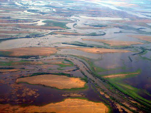
In the area of convergence with the Don, the river turns and flows further to the southeast until it flows into the Caspian Sea. In the place where the Akhtuba separates from the main channel, the Volga delta begins. It covers an area of approximately 19 thousand square kilometers. Delta consists of 500 arms. The largest of them are Akhtuba, Bakhtemir, Kamyzyak, Staraya Volga, Bolda, Buzan. The second branch of these is constantly maintained navigable and forms the Volga-Caspian canal. Kigach, which is also one of the branches of the great river, crosses the territory of Kazakhstan.
Considered the largest in Europe. Throughout history, it has changed its position and occupied area. The delta of the modern type was formed around the 3rd century AD, when the old channel could not cope with the increased volume of water. Over the past 130 years, the level of the Caspian Sea has been decreasing. As a result, during this period, the area of the delta increased by about 9 times.
At the mouth of the Volga is the last city on this river - Astrakhan. It is located on eleven islands in the upper part of the delta.

Nutrition and mode
The Volga River, the geographical position of which was discussed above, before the construction of reservoirs was characterized by significant level fluctuations (below the mouth of the Kama, they reached 17 m). Today, such serious drops and spills are not observed.
Most of the river is fed by snow waters (up to 60%). A significant role in this process is also played by rain (10%) and ground (30%) “inflows”. Throughout the year, the Volga goes through several successive transformations. Spring (April to June) is high water. In summer and winter, the level in the river decreases markedly. In autumn (usually in October) there are rain floods.

During the hottest months, the water temperature in the river reaches 25º. The Volga freezes in the upper and middle sections, as a rule, in November, in the lower section - not earlier than December. The river is freed from ice first of all near Astrakhan (in March). The Upper Volga, as well as the area below Kamyshin, opens up in the first half of April. The rest of the river comes out of its winter slumber in the middle of this month.
Natural resources
The Volga on the map occupies a vast territory. It flows through the forest, forest-steppe zone and steppe. The river has been famous for its fish wealth since ancient times. Bream, roach, sterlet, carp, catfish, pike live here. Unfortunately, the construction of reservoirs and water pollution do not contribute to the conservation of all this diversity. A nature reserve has been created in the Volga delta. Since 1919, unique plants and animals have been under state protection on its territory. Among them are lotus, sturgeons, pelicans, flamingos.
The Volga (geographical position, nutrition, unique flora and fauna) is well studied today. Along with the understanding of the changes that have taken place with the river throughout the entire time of its existence, comes the awareness of the problems associated with them. Today, the great Russian river is in dire need of protecting its wealth. Fortunately, more and more people are becoming aware of the dangers of environmental problems. One can therefore hope that the unique nature and beauty of the Volga banks will be preserved for many more centuries.
There are stories about travels to Cuba, Jamaica, the Dominican Republic, Switzerland, Spain, Peru and Venezuela.
Description: Volga (in ancient times - Ra, in the Middle Ages - Itil, or Etel), - a river in the European part of Russia, one of the largest rivers in the world and the largest in Europe. Length 3530 km (before the construction of reservoirs 3690 km). The area of the basin is 1360 thousand km2.
The Volga originates on the Valdai Hills at an altitude of 228 m and flows into the Caspian Sea. The mouth lies 28 m below sea level. The total fall is 256 m. The Volga receives about 200 tributaries. The left tributaries are more numerous and more abundant than the right ones. The river system of the Volga basin includes 151 thousand watercourses (rivers, streams and temporary watercourses) with a total length of 574 thousand km. The Volga basin extends from the Valdai and Central Russian uplands in the west to the Urals in the east. At the latitude of Saratov, the basin narrows sharply, and the Volga flows from Kamyshin to the Caspian Sea without tributaries. The main, feeding part of the Volga drainage area, from its sources to Nizhny Novgorod and Kazan, is located in the forest zone, the middle part of the basin to Samara and Saratov is in the forest-steppe zone, the lower part is in the steppe zone to Volgograd, and to the south - in the semi-desert zone.
It is customary to divide the Volga into three parts: the upper Volga - from the source to the mouth of the Oka, the middle Volga - from the confluence of the Oka to the mouth of the Kama, and the lower Volga - from the confluence of the Kama to the Caspian Sea. After the construction of the Kuibyshev reservoir, the boundary between the middle and lower Volga is usually considered to be the Zhigulevskaya HPP upstream of Samara.
The source of the Volga is the key near the village of Volgoverkhovye in the Tver region. In the upper reaches, within the Valdai Upland, the Volga passes through small lakes - Verkhit, Sterzh, Vselug, Peno and Volgo. As early as 1843, a dam (Upper Volga Beishlot) was built at the source of Lake Volgo to regulate the flow of water and maintain navigable depths in low water. Between Tver and Rybinsk on the Volga, the Ivankovskoye reservoir with a dam and a hydroelectric power station near Dubna, the Uglich reservoir (hydroelectric power station near Uglich) and the Rybinsk reservoir (hydroelectric power station near Rybinsk) were created. In the region of Rybinsk - Yaroslavl and below Kostroma, the river flows in a narrow valley among high banks, crossing the Uglich-Danilov and Galich-Chukhloma uplands. Further, the river flows along the Unzha and Balakhna lowlands. At Gorodets (above the city of Nizhny Novgorod), the Volga, blocked by the dam of the Nizhny Novgorod hydroelectric power station, forms the Gorky reservoir. The main tributaries of the upper Volga are Selizharovka, Tvertsa, Mologa, Sheksna and Unzha. In the middle reaches, below the confluence of the Oka, the Volga becomes even more full-flowing. It flows along the northern edge of the Volga Upland. The right bank of the river is high, the left is low. The Cheboksary hydroelectric power station was built near Cheboksary, above which the reservoir of the same name is located. For a number of reasons, the hydroelectric power station has not yet been brought to its design capacity, and the level of the Cheboksary reservoir is 5 meters below the design level. In this regard, the section from the Nizhny Novgorod hydroelectric power station to Nizhny Novgorod remains extremely shallow, and navigation on it is carried out thanks to water releases from the Nizhny Novgorod hydroelectric power station in the morning. At the moment, the final decision on filling the Cheboksary reservoir to the design level has not been made. As an alternative option, the possibility of constructing a low-pressure dam combined with a road bridge above Nizhny Novgorod is being considered. The largest tributaries of the Volga in its middle reaches are the Oka, Sura, Vetluga and Sviyaga.
In the lower reaches, after the confluence of the Kama, the Volga becomes a mighty river. It flows here along the Volga Upland. Near Togliatti, above the Samarskaya Luka, which is formed by the Volga, skirting the Zhiguli mountains, the dam of the Zhigulevskaya hydroelectric power station (the former Volga hydroelectric power station named after V. I. Lenin) was built; above the dam extends the Kuibyshev reservoir. Downstream - in the area of the city of Balakovo, the dam of the Saratov hydroelectric power station was erected. The Lower Volga receives relatively small tributaries - Samara, Big Irgiz, Eruslan.
21 km above Volgograd, the left branch - Akhtuba (length 537 km) - separates from the river, which flows parallel to the main channel. The vast space between the Volga and Akhtuba, crossed by numerous channels and old rivers, is called the Volga-Akhtuba floodplain; the width of floods within this floodplain reached 20-30 km before. On the Volga, between the beginning of Akhtuba and Volgograd, there is the Volzhskaya HPP (the former Volzhskaya HPP named after the 22nd Congress of the CPSU).
The river delta begins at the point of separation from its channel of the Buzan branch (46 km north of Astrakhan) and is one of the largest in Russia. There are up to 500 branches, channels and small rivers in the delta. The main branches are Bakhtemir, Kamyzyak, Staraya Volga, Bolda, Buzan, Akhtuba (of which Bakhtemir is navigable).
The Volga is mainly fed by snow (60% of annual runoff), ground (30%) and rain (10%) waters. The natural regime is characterized by spring floods (April - June), low water levels during the summer and winter low water periods, and autumn rain floods (October). Annual fluctuations in the level of the Volga before the construction of a cascade of waterworks reached 11 m near Tver, 15-17 m below the Kama mouth, and 3 m near Astrakhan. With the construction of reservoirs, the flow of the Volga was regulated, level fluctuations sharply decreased.
The average annual water consumption at the Upper Volga Beishlot is 29 m3/sec, at Tver - 182, at Yaroslavl - 1110, at Nizhny Novgorod - 2970, at Samara - 7720, at Volgograd - 8060 m3/sec. Below Volgograd, the river loses about 2% of its discharge to evaporation. The maximum water flow during floods in the past below the confluence of the Kama reached 67,000 m3/s, and near Volgograd, as a result of a spill over the floodplain, they did not exceed 52,000 m3/s. In connection with the regulation of the runoff, the maximum flood discharges have sharply decreased, while the summer and winter low water discharges have greatly increased.
Prior to the creation of reservoirs, during the year, the Volga carried to the mouth about 25 million tons of sediment and 40-50 million tons of dissolved minerals. The water temperature of the river in the middle of summer (July) reaches 20-25°C. The Volga breaks up near Astrakhan in mid-March, in the first half of April, the break-up occurs on the upper Volga and below Kamyshin, for the rest of its length - in mid-April. The river freezes in the upper and middle reaches at the end of November, in the lower - at the beginning of December; Free from ice remains about 200 days, and near Astrakhan about 260 days. With the creation of reservoirs, the thermal regime of the Volga changed: in the upper pools, the duration of ice phenomena increased, and in the lower pools it became shorter.
Historical and economic-geographical essay. The geographical position of the Volga and its large tributaries determined already by the 8th century. its importance as a trade route between East and West. Fabrics, metals were exported from Central Asia, furs, wax, and honey were exported from the Slavic lands. In the 9th-10th centuries. such centers as Itil, Bolgar, Novgorod, Rostov, Suzdal, and Murom played a significant role in trade. From the 11th century trade weakens, and in the 13th century. the Mongol-Tatar invasion disrupted economic ties, except for the basin of the upper Volga, where Novgorod, Tver and the cities of Vladimir-Suzdal Rus played an active role. From the 14th century the importance of the trade route is being restored, the role of such centers as Kazan, Nizhny Novgorod, Astrakhan is growing. Conquest by Ivan IV the Terrible in the middle of the 16th century. The Kazan and Astrakhan khanates led to the unification of the entire Volga river system in the hands of Russia, which contributed to the flourishing of the Volga trade in the 17th century. There are new large cities - Samara, Saratov, Tsaritsyn; Yaroslavl, Kostroma, and Nizhny Novgorod play an important role. Large caravans of ships (up to 500) float along the Volga. In the 18th century the main trade routes are moving west, and the economic development of the lower Volga is constrained by poor population and nomadic raids. The Volga basin in the 17th-18th centuries was the main area of operations of the rebellious peasants and Cossacks during the peasant wars under the leadership of S. T. Razin and E. I. Pugachev.
In the 19th century there is a significant development of the Volga trade route after the connection of the Mariinsky river system of the Volga and Neva basins (1808); a large river fleet appeared (in 1820 - the first steamboat), a huge army of barge haulers (up to 300 thousand people) worked on the Volga. Large shipments of grain, salt, fish, and later oil and cotton are made along the Volga. The Nizhny Novgorod fair acquires great economic importance.
During the Civil War of 1918-1920, major military operations took place on the Volga, and it acquired important military and strategic importance. Since the end of the 30s. In the 20th century, the Volga also began to be used as a source of hydropower. During the Great Patriotic War of 1941–45, the largest Battle of Stalingrad (1942–43) took place in the East. In the post-war period, the economic role of the Volga increased significantly, especially after the creation of a number of large reservoirs and hydroelectric power stations. After the completion of the construction of the Volga-Kama cascade of HPPs, the total generation of electricity reached 40-45 billion kWh per year, the area of the reservoir mirror was about 38 thousand km2, the total volume was 288 km3, and the useful volume was 90 km3.
The Volga is connected to the Baltic Sea by the Volga-Baltic Waterway; with the White Sea - through the White Sea-Baltic Canal and the Severodvinsk system; with the Azov and Black Seas - through the Volga-Don Canal. An important role is played by the Moscow Canal, which connects the Volga with Moscow and was created for the purpose of navigation, water supply of the capital and watering of the Moscow River. Currently, regular navigation along the Volga is carried out from the city of Tver. (According to the materials of the site: www.riverfleet.ru)
A.S. Glednev report "The Volga River - and its significance"
There are many large and beautiful rivers in Russia, such as the IRTYSH, LENA, ANGARA, OB. One of the largest and most beautiful Russian rivers in Europe is the Volga River, the 16th longest in the world.
“Each country has its own national river,” Dumas wrote. “Russia has the VOLGA, the largest river in Europe, the queen of our rivers, and I hastened to bow to Her Majesty the Volga River!” Geologists determine from deposits in the earth’s crust what an immeasurably long In the history of the Earth, significant areas of the present Volga region have repeatedly turned into the seabed. One of the seas slowly receded to the south about twenty million years ago, and then the Volga River flowed in its wake. The Volga did not begin in Valdai, but near the Ural Mountains. She, as it were, cut a corner, taking the direction from there to the Zhiguli, and then carried the waters much more east than now. Movements of the earth's crust, the formation of new heights and depressions, sharp fluctuations in the level of the Caspian Sea and other reasons forced the Volga River to change direction.
RA - this is how the Greek scientist Ptolemy called the Volga River in his "Geography". He lived far from the Volga, on the coast of Africa, in the city of Alexandria, but rumors about the great river also reached there. It was in the second century AD. ITIL, ETIL, ATIL... Such names of the Volga River are noted in medieval chronicles.
The source of the Volga River on the Valdai Upland, where groundwater comes out. The Volga is a typical flat river. The Volga River flows into the Caspian Sea. At the confluence of the Volga forms a delta with an area of 19 thousand square meters. km.
For almost 370 km. she rolls her waters from them for 3500 km. ships are allowed to move. At this distance, it descends no more than 250 m. The fall of the river is small. The average flow velocity is less than 1 m/s.
Most of the rivers are tributaries of other larger rivers. OKA is the right tributary of the Volga, KAMA is the left tributary of the Volga River. Smaller rivers, when flowing into larger ones, form the basin of the main river, due to which the rivers are full-flowing. The Volga river basin is 1360 thousand square meters. km.
The main food of the Volga River is melted spring waters. Rains, which fall mainly in summer, and groundwater, due to which the river lives in winter, play a lesser role in its nutrition. In accordance with this, in the annual level of the river, there are: high and prolonged spring floods, a fairly stable summer low water and a low winter low water. The duration of the flood is an average of 72 days. The maximum rise in water usually occurs in the first half of May, half a month after the spring ice drift. From the beginning of June to October - November, a summer low water is established. Thus, most of the navigation period, when the Volga River is ice-free (on average 200 days), coincides with the period of low low water levels (2 - 3 m).
The Upper Volga - from the source to Nizhny Novgorod, to the confluence of the Oka, the middle - from the mouth of the Oka to the mouth of the Kama, the lower Volga - from the confluence of the Kama to the Caspian Sea.
From the city of Nizhny Novgorod, after the confluence of the Volga with the Oka, as is commonly believed, the middle course of the Volga begins. The width of the riverbed immediately more than doubles, then fluctuating in the range from 600 to 2000 m. And more.
The middle Volga is characterized by three main types of banks. On the right, the ancient banks, unflooded at any level of water, rise down to the river in steep slopes; sometimes, at a turn, such a bank protrudes into the Volga River, forming a cliff. On the left, extremely gentle, gradually rising to a low meadow floodplain, sandy shores predominate, alternating with "ravines - steep, almost sheer slopes, clayey, sandy-clayey; in some places they reach a considerable height." noiselessly, solemnly and unhurriedly flow its waters; the mountain shore is reflected in them with a black shadow, and on the left side it is decorated with sandy rims of shallows, wide meadows with gold and green velvet "(M. Gorky," Foma Gordeev ").
The difference between the right and left banks of the Volga River affects the settlement and economic development of the banks of this river. The quiet backwaters of the left bank are widely used for parking, wintering, repair and construction of ships: along the entire Volga coast of the Volga there are settlements of shipbuilding and ship repair plants.
Left-bank villages on the Volga River, and settlements are located, as a rule, far from the river, outside the low, flooded floodplain, with the exception in this respect are the villages on high ravines. The wide left-bank floodplain is rich in meadows; Collective farmers also come here to mow from the right bank, where floodplains are small. Another thing is on the right bank. The villages are often located "right above the Volga River", on the top of the bedrock bank and on the slopes.
The high right bank of the Volga River is fraught with a constant threat of landslides and landslides, which is unfavorable for settlement on it. The condition for their occurrence is the interbedding of water-resistant clayey and aquiferous sandy horizons observed on the right bank, with their exit towards the river. The Volga rivers saturated with water after snowmelt or summer showers, the upper sandy-argillaceous strata begin to slide along the water-resistant layer towards the river. This sliding can be very slow, but in the end, it can lead to a collapse. Landslides are being combated by strengthening dangerous sections of the coast, the construction of drainage systems.
Abstract: The Volga River
Volga river
1. Volga - the great Russian river
Our country is rich in rivers: there are almost 200 thousand of them. And if you pull them out one after another, you get a ribbon about 3 million km long, many dozens of times it could wrap around the globe along the equator.
“Throw a look at Russia from above - it has turned blue with rivers.”
V. Mayakovsky
“Each country has its own national river. Russia has the Volga - the largest river in Europe, the queen of our rivers - and I hastened to bow to Her Majesty the Volga, ”Dumas wrote.
The Volga is the 16th longest river in the world and the 5th in Russia. Like a giant tree, the Volga spread its branches across the great Russian plain - tributaries. It captured almost 1.5 million km2 within the boundaries of its basin. Originating as a small stream among forests and swamps near the village of Volgoverkhovye in the center of the Valdai Upland, the Volga, on its way to the sea, receives tribute from numerous tributaries (the largest of them are the Oka and Kama) and turns into a mighty river, the largest in all of Europe, with a length of 3700 km, carrying its waters into the inner Caspian Sea-lake. In the lower reaches (after Volgograd) it has no tributaries.
“... - seven thousand rivers
She collected from all over -
Big and small - up to one,
What from Valdai to the Urals
They furrowed the globe of the earth "
A. Tvardovsky
(poem "For the distance distance")
The Volga is a typically flat river. From source to mouth, it descends only 256 meters. This is a very small slope compared to other great rivers in the world, which gives very great convenience for navigation.
“... they are slowly moving towards the banks of the Volga, - the left one, all drenched in the sun, spreads along to the edge of the sky, like a lush, green carpet, and the right waved its slopes, overgrown with forest, to the sky, and froze in stern peace. A broad-breasted river stretched majestically between them; noiselessly, solemnly and unhurriedly flow its waters ... "
M. Gorky
According to its natural features, the natural, former Volga is a typical Eastern European mixed-flow river with a predominance of snow, with a long freeze-up and a summer decline in water.
During the year, a huge amount of water flows down the Volga - about 250 km3.
According to natural features, the Volga is usually divided into three parts. From the source to the confluence of the Oka, it is called the Upper Volga, then to the confluence of the Kama - the Middle and from the Samara Luka to the mouth - the Lower. The territory where the river flows is called the Upper Volga, Middle and Lower Volga regions, respectively.
2. Historical Volga
The great Russian river Volga has long been known to the Greeks. Ra (which meant "Generous") - this is how the Greek scientist Ptolemy called the Volga in his "Geography". He lived far from the Volga, on the coast of Africa, in the city of Alexandria, but rumors about the great river also reached there. It was in the 2nd century AD.
The Finnish tribes living on its banks called the Volga River - “Light”, “Shining”, and the Arabs in the Middle Ages called it “Iyshl” - “River of Rivers”. Some geographers believe that the name "Volga" comes from the Russian words "moisture", "water". Entire pages of the history of the Russian state and its people are connected with the word Volga. There was a time when, crushed by extortions, driven from the land, hungry and impoverished, the Volga peasants went to the great river. Here they huddled together in artels and pulled barges down the Volga day and day, in rain and snow, in heat and cold. This is well reflected in the picture by I.E. Repin "Barge haulers on the Volga". Even the strongest could not stand this hard labor, and brought many to the grave ahead of time. But others made millions from their slave labor. "The river of slavery and longing" called the Volga N.A. Nekrasov.
"Come out to the Volga, whose groan is heard
Over the great Russian river?
We call this moan a song,
That barge haulers are towing.
In some years in the past, when a lot of snow fell in winter, the water level near Volgograd reached 10-14 m. But it was not always so. More often, there were periods when there was little water, and the Volga became very shallow in summer.
In 1885, a cute picture was depicted on the cover of the Alarm Clock magazine: a beautiful woman lies on her deathbed - this is the Volga. Nearby, her daughters, Oka and Kama, are crying in a kneeling pose. Saddened stand at the bed of the dying - History, Trade, Poetry. The doctor throws up his hands - I can’t help you with anything. The shallowing reached the point that large ships no longer sailed above N.-Novgorod.
The Volga and its cities endured many trials during the years of the civil war and the military intervention of foreign states. Counter-revolutionary rebellion in Samara ("death trains"), military threat (1918) to Samara and Simbirsk, now from Kolchak's army. In the battles for the liberation of these cities, units under the command of V.I. Chapaev. Fierce battles went on for Tsaritsyn, which was the key to the grain regions of southern Russia and Baku oil.
In the first half of 1918, 5,037 wagons of food were sent through Tsaritsyn to Moscow and Petrograd. That is why the White Guards rushed to Tsaritsyn: they sought to deprive the young Soviet Republic of bread and fuel. In the second half of 1919, the city was occupied by the White Guard troops of General Wrangel, where the defenders were brutally massacred. 3.5 thousand people became victims of terror. In January 1920, the Red Army drove the troops out of the city. To fight for the Volga and its cities during the Civil War, at the suggestion of Vladimir Ilyich Lenin, in April 1918, the first Soviet river military flotilla was created. It consisted of river vessels and a group of warships delivered from the Baltic Fleet. The flotilla operated on the Volga and its channels and went down in history as the Volga military flotilla. With the participation of the Volga flotilla, the White Guard units near Sviyazhsk were defeated, Kazan, Syzran, Volsk, Samara were liberated. In July 1919, she became part of the Volga-Caspian military flotilla.
Special mention should be made of those terrible and difficult months when, during the Great Patriotic War (WWII), the fate of our state was decided on the banks of the Volga. We are talking about the Battle of Stalingrad, which marked a turning point in the course of the war, seeing that it was not possible to take Moscow by storm, the Nazi command changed its plans. It decided to direct the main blow south of the capital, to seize Ukraine and the Volga region with their innumerable food and material resources. Particular importance was attached to the early physical destruction of Stalingrad - the largest industrial center on the Volga, which supplied the fronts of World War II with tanks, armored personnel carriers, guns, and ammunition. Then it was planned to advance to Astrakhan and cut the main channel of the Volga there. The plans of the enemy were unraveled. On the near and far approaches to the city, 100 thousand people erected four defensive lines in a short time. Leaving the fortifications, the builders wrote on the walls: “Fighter, be steadfast! Not a step back, remember, behind your back is the Volga, Our Motherland! From the summer of 1942 to February 1943, the heroic saga of the battle for Stalingrad and the Volga lasted. At the beginning of 1942, the Volga military flotilla was re-created from the converted ships of the Volga River Shipping Company, which in the period from 11/19/1942 to 12/16/1942. (during the counter-offensive near Stalingrad) transferred over 27 thousand people and 1300 tons of military cargo to the right bank of the Volga. The Nazis were squeezed into "pincers", and then completely surrounded. On February 2, 1943, the Germans surrendered. This battle lasted 6.5 months. For Germany, the battle on the Volga for Stalingrad was the gravest defeat, and for Russia - the greatest victory. After the defeat on the Volga, the Nazis were no longer able to recover. There was a great turning point in the war. The victorious offensive of our troops began on all fronts.
After the liberation of Stalingrad, the Volga Flotilla did a great job of clearing mines from the Volga.
On the site of the ruins, the ashes of Stalingrad, people created a new, even more beautiful city and called it Volgograd, in honor of the great Russian river.
3. Great Volga Cascade
The young Soviet state got: a shallow river, the miserable remnants of the fleet, the ruined port facilities. To prevent catastrophic consequences, it was necessary to transform the Volga system. To this end, even before the war, a plan was conceived and developed to turn the Volga into a cascade of dams, reservoirs and the construction of new canals on it. The prophetic words of the poet K.A. Nekrasov:
Other times, other pictures
I foresee the start...
Freed from shackles
The people are relentless
Ripens, densely populates
coastal deserts;
The science of water will deepen
On their smooth plain
Giant ships will run
Innumerable crowd,
And cheerful work will be eternal
Over the eternal river
A large group of scientists and engineers worked on the creation of this grandiose plan. This plan was given the strategic name "Big Volga". He was complex. This means that during its development, the needs of navigation, irrigation, energy, water supply and much more were taken into account and provided for. According to the project, the Volga was supposed to turn into a wide waterway, connect with the northern and southern seas, become a powerful factory of electrical energy and direct part of its waters for irrigation in arid regions. The Great Volga project began to be implemented from the moment when the construction of the Moscow Canal began.
The canal was built from 1932 to 1937. It was necessary to immediately solve two important problems: to make the capital a large river port and to give it plenty of fresh drinking water. Its length is 128 km. Water by five pumping stations rises 40 meters to the Volga-Moscow watershed, and then follows by gravity.
About 200 structures were erected on this "man-made river": 10 dams, 11 locks, dozens of bridges. 8 HPPs have been built. Many buildings are decorated with bas-reliefs, statues, frescoes. When you float along the canal, it seems that you are in a museum of monumental sculpture. Channel traffic never stops.
Ivankovsky waterworks - the main structure of the canal. Near the village of Ivankovo, the Volga was blocked by a dam and forced to spill over the floodplain. The Moscow Sea arose here, and the river began to rotate the turbines of the Ivankovskaya hydroelectric power station. The news that the Russians for the first time in history stopped and forced to work for themselves the greatest river in Europe spread all over the world. The HPP's capacity was modest, only 30,000 kW.
Later, below Ivankov, the construction of the Uglich and Rybinsk hydroelectric facilities began. The Uglich HPP with a capacity of 110 thousand kW was built in 1940, and the first stage of the Rybinsk HPP was built in 1941. The Upper Volga hydroelectric power stations during the difficult war winter (1941-1942) supplied up to 3.5 billion kWh. electricity. The Rybinsk "sea" at that time was the largest artificial reservoir in the world.
The Upper Volga, for 1300 km, became subject to man. The central energy system was filled with new strength, deep-sea Astrakhan river ships reached Moscow.
In the 1950s, the construction of the Rybinsk hydroelectric power station was completed on the Volga. In 1956, the construction of the Gorkovskaya hydroelectric power station (Nizhny Novgorod) was completed.
At the beginning of the Samarskaya Luka above the city of Samara, in 1950, work began on the Volga near the Zhiguli to build the Samara hydroelectric power station. After 8 years, the work was completed, the Volga Hydroelectric Power Station named after V.I. Lenin (Samara) with a capacity of 2.3 million kW. This is a powerful building. The building of the Samara HPP "Palace of Electricity" is longer than the building of the Admiralty in St. Petersburg (it was considered the longest in the USSR).
A river approximately equal to the Oka flows through each turbine, and the Kuibyshev reservoir occupies about 6 thousand km2. In general, a titanic work has been done. It was necessary to bring railway tracks, hang cable cars over the Volga, break up settlements, drive a steel fence into the bottom of the river, go deep behind it with excavators much lower than the channel, lay a mountain of concrete, wash a shaft of earth across the entire river and start cars along its crest and trains, raise the Volga by 25-26 meters, arrange locks and mount units - each with an 8-storey building growth, stretch the wall of the dam 5 km long. Help came from everywhere: automatic concrete plants from Moscow, bucket-wheel electric excavators from Kyiv, dump trucks from Minsk, turbines from Leningrad.
In 1951-62. the Volgograd hydroelectric complex is being built from the Volgograd hydroelectric power station with a capacity of 2.5 million kW. The Volgograd and Kuibyshev reservoirs irrigate over 2,000 hectares of fertile arid lands.
In the same years, the first hydroelectric power station was built on the Kama, not far from the city of Perm - the Kama hydroelectric power station with an original design (combines a spillway dam and a hydroelectric power station building), which results in savings in the cost of concrete structures.
Then the Volzhskaya hydroelectric power station with a capacity of 1 million kW and the Nizhnekamsk hydroelectric power station are being built. Since 1967, the first units of the Saratov hydroelectric power station began to give current. The launch of the Cheboksary HPP has practically completed the construction of the Volga-Kama cascade. The whole complex of structures on the Volga was called the "Great Volga Cascade". The Volga-Kama HPP cascade formed a system of reservoirs (from Kostroma to Volgograd), which makes it possible to redistribute the flow of water according to the seasons in accordance with the requirements of the national economy and irrigate the arid lands of the Middle and Lower Volga region (more than 2 million hectares, which is about half of all irrigated lands of Russia).
The Volga supplies water to thousands of enterprises and dozens of urban settlements located on its banks.
Volzhsky and Kamsky HPPs allow saving up to 25-30 million tons of coal annually. In addition, the hydroelectric power station performs the functions of regulating the load schedule of power systems. The cost of energy from hydroelectric power plants is 4-5 times lower than the cost of electricity from thermal power plants in the regions of the Volga region and the Center.
The creation of a cascade of HPPs improved navigation conditions: a deep-water route was formed with uniform guaranteed depths (3.65 m) over 3,000 km on the Volga and 1,200 km on the Kama, which reduced the cost of transportation in the Volga basin by 2-3 times compared to other inland waterways. ways and 2-3 times in comparison with the adjacent railways.
But there were also negative aspects in the transformation of the Volga. In order to obtain a large amount of electricity, they went to flood land over large areas. Two million hectares of land, thousands of villages and even some cities were under water. After the construction of hydroelectric dams, the fishery importance of the Volga decreased due to the deterioration of water quality (industrial effluents) and the difficulty of spawning fish.
4. Volga - transport highway
In distant geological epochs, it so happened that nature “offended” the Volga, depriving it of access to the ocean, and forcing it to flow into the inland sea.
This circumstance has long caused great inconvenience to the Russian people who communicated with other neighboring peoples. The lively Black Sea market has always attracted Russian merchants.
The need to connect the Volga with the Don is long overdue. The first attempt to connect the great rivers was made by the Turks, who wanted to transfer warships, heavy guns and troops by water along the Don and Volga in order to take away Astrakhan from us, annexed to Russia in 1556.
For this, their Sultan Selim II ordered a tunnel to be made in the place of the drag between the rivers. Ivan the Terrible, having learned about the uninvited guests, sent a large army to the place of work, but they fled even earlier from the inhospitable Russian land. "Turkish ditch" has survived to our time.
Peter I also dealt with the problem of connecting the Volga and the Don. But this idea was really implemented only from 1948 to 1952. The Volga was connected to the Don. Here the Volga-Don canal arose. It starts from the Volga near Volgograd and comes to the Don at Kalach. The length of the route is 101 km. There are 9 locks on the Volga slope, 4 on the Don slope. Tens of millions of tons of all kinds of cargo go through it. So the Volga got access to the southern seas - the Azov and the Black.
But it wasn't enough for her. She badly needed access to the northern seas - convenient and accessible for large modern ships. On the site of the outdated "Marinka" (a waterway connecting the basins of the Volga and Neva rivers in 1810), a new large deep road Volga-Balt - the Volga-Baltic waterway 360 km long was created. Instead of dilapidated small locks, seven new ones with several hydroelectric stations were built here. In 1964, for the first time, large ships and motor ships passed through it from the Volga to the Baltic.
And, finally, the White Sea-Baltic Canal connected the Volga with the White Sea.
Thus, the modern Volga is a waterway connected with the five seas of Europe. Day and night, a variety of goods flow along it in an endless stream - building materials and timber, cars and coal, oil, salt, bread, vegetables and fruits. Two-thirds of the republic's river cargo is transported along the Volga and its tributaries. It has 1450 ports and marinas and all the largest cities of the Volga region. The Volga unites them as a great transport artery. Freight turnover on it is 10 times higher than the railway in this area.
5. Volga - the economic axis of the Volga region
At the turn of the 19th and 20th centuries, the industrialization of the Volga region began. It becomes a major area for the production of marketable grain and the flour-grinding industry. The importance of the Volga is growing. It becomes the "main street of Russia" (grain, oil are transported, timber is rafted). The most powerful sawmills in Russia appear in Tsaritsyn (Volgograd).
The industrialization policy during the years of the pre-war five-year plans (the largest tractor plant in Volgograd) and the first years of the war (due to the evacuation of defense enterprises here in 1941-42) made the Volga region from an agrarian - industrial one, from a flour milling one - a machine-building one with an enhanced development of the military industry.
In the post-war period, especially since 1950, for two decades, the Volga region became the main region of Russia for oil production and its processing of petrochemicals. The main areas of oil and gas production and processing are located in Tataria (Almetievsk, Yelabuga), Samara region (Novokuibyshevsk, Syzran, Otradny). The flow of oil has changed. She has now gone down the Volga. The Volga region has become a land of oil and gas.
At present, the main branches of specialization of the Volga region are mechanical engineering and petrochemistry. Mechanical engineering (18.6% of Russian) is represented mainly by military-industrial complex enterprises, the main branch of specialization of which is the aviation and rocket and space industries. The largest centers of the military-industrial complex are Samara, Kazan, Saratov, Ulyanovsk.
A special place in the mechanical engineering of the Volga region belongs to the transport region of the Volga region - the automobile workshop of the country. It is the largest manufacturer of cars and trucks (Naberezhnye Chelny, Ulyanovsk, Tolyatti, Nizhny Novgorod).
Of the other modes of transport, aircraft manufacturing is developed (Kazan, Nizhny Novgorod, Saratov, Samara, Ulyanovsk), shipbuilding (Rybinsk, Volgograd, Astrakhan) - sea and river vessels, including hovercraft (Sormovo, Nizhny Novgorod).
The Volga region is a major manufacturer of tractors (Volgograd, Cheboksary), car building (Tver), machine tool building, instrument making, excavators and much more are developed.
Although oil production is declining, but oil refining and petrochemistry are switching to Siberian oil, Astrakhan gas, so the Volga region is still the country's largest region for oil refining, chemical products, and organic synthesis.
It produces plastics, chemical fibers, synthetic rubber, tires ("shoes for cars"), mineral fertilizers.
The share of the Volga region in the chemical and petrochemical industry is 15.1% of Russia (Kazan, Balakovo, Engels, Volgograd).
Light industry has retained its importance and is growing. This is textile (Tver, Kineshma, etc.), food (everywhere). Of particular note is the extraction and processing of table salt from Lake Baskunchak, which has long been used as the “All-Russian salt shaker”. The only mustard plant in the country operates in Volgograd. The mining and processing fish industry (Astrakhan) is successfully developing.
There are 67 cities on the banks of the Volga. They all stretched out along or near it. The largest of them are as follows.
Nizhny Novgorod (former Gorky) - the first city on the Volga and the third largest in Russia (1 million 357 thousand inhabitants), was founded in the 13th century by Prince Vladimir Yuri Vsevolodovich and was of great strategic importance at that time. Its location at the confluence of the Oka with the Volga contributed to the development of industry and trade.
In 1817, the Makariev Fair was transferred to Nizhny Novgorod (previously it was held in the town of Makaryevo, on the left bank of the Volga), which occupied a huge area on the spit of the Oka and Volga. Now she is reborn again.
Since the middle of the 19th century, the city has gained industrial importance. The Sormovo Shipbuilding Plant, now Krasnoye Sormovo, was built there, where sea and river hydrofoil ships (Rocket, Meteor, Kometa) are built. Gorky's Volga cars and trucks (with the emblem of a deer figure on the hood) and GAZ (the famous "gaziki") are known all over the world.
There is a large river port in Nizhny Novgorod. The department of the Volga United River Shipping Company is located here. The life of many outstanding people of Russia is connected with the history of this city. The Ulyanov family lived here. This is the birthplace of A.M. Gorky, Russian inventor Kulibin, mathematician Lobachevsky and many other prominent figures. The grave of Kuzma Minin is located in the Archangel Cathedral of the Nizhny Novgorod Kremlin. The Cathedral of Alexander Nevsky and others are also known.
The second largest population in the Volga region (1 million 156 thousand) is the city of Samara, founded in the 16th century as a fortress in the bend of the Volga near the confluence of the Samara River (which gave the city its name). During the Second World War, dozens of industrial enterprises were evacuated here, turning the city into one of the largest centers of engineering (aircraft, various machine tools, drills for wells, electrical equipment for cars and tractors). Samara is a center for the manufacture of bearings of all-Union significance. The metal-working and chemical industries are developed here. Samara is famous for the largest and most comfortable embankment, dressed in concrete and Ural granite. Samara is the birthplace of the famous Zhiguli beer. The city is also known for its chocolate factory "Russia".
The capital of Tatarstan - Kazan (1 million 101 thousand people), was founded in the 12th century as a fortress and a trading center, on the border of the Volga Bulgaria and Russian lands. It is a large industrial center and the main center of Tatar culture in Russia. Here are developed: mechanical engineering and chemical industry. It supplies the national economy with turbo-refrigeration and electronic computers, compressors, synthetic rubber, polyethylene, film, household chemicals, and so on.
Kazan is the most university city. Scientists of Kazan University N.I. Lobachevsky, V.M. Bekhterev, A.V. Vishnevsky brought glory to domestic science. Leo Tolstoy studied at Kazan University. F.I. was born in this city. Chaliapin, passed his "universities" A.M. Bitter. In the former bakery where he worked, a museum was opened to them. Gorky.
There are many memorable places in Kazan connected with the development of the labor movement, with the revolutionary events of 1917, with the liberation of Kazan from the White Guards and interventionists in 1918. Near the walls of the Kazan Kremlin there is a monument to the hero of the Soviet Union Musa Jalil, who wrote his immortal poems about the fearlessness and resilience of the Soviet people (“Moabit Notebook”) in the fascist dungeons. For these poems in 1957, the poet was awarded (posthumously) the Lenin Prize.
The Kazan river port is one of the largest on the Volga. Routes of all transit, transport and tourist lines of steamships of the central basins pass through it.
The largest city of the Lower Volga region is Volgograd, known since the end of the 16th century under the name Tsaritsyn (from the river Tsaritsa, which flows into the Volga). The city is stretched along the right bank of the Volga for 80 km from the dam of the Volgograd hydroelectric power station to the locks of the Volga-Don Canal. It arose in the place of the closest approach of the two great rivers of the Russian plain, the Volga and the Don, and developed as a center of trade, transshipment of timber, extraction and processing of the Volga fish resources.
Today's Volgograd is a major industrial center of the Volga region. It has developed metallurgy (Krasny Oktyabr plant), mechanical engineering, including the largest tractor-building plant, chemical oil refining, light industry, food and other industries. Volgograd is a major transport hub.
With Volgograd (Tsaritsyn and Stalingrad), as mentioned above, the history of Russia is connected during the Civil and WWII wars. Volgograd residents honor the memory of the fallen heroes both during the defense of Tsaritsyn and during the great battle of Stalingrad. On Mamaev Kurgan, a monument was created - the ensemble "To the Heroes of the Battle of Stalingrad".
The second largest city in the Lower Volga region is the city of Saratov (874 thousand inhabitants). It first became a center for the processing of agricultural products, especially grain. Then machine-building, shipbuilding, nail-and-wire plants appeared, later large oil refineries, chemical plants, the largest technical glass plant in Europe (used in the construction of the Kremlin Palace of Congresses in Moscow), and a large-panel housing construction plant were built. Mobile power plants, refrigerators, and light and food industry products are produced.
Saratov is a major center of science, culture and education. Saratov is the birthplace of N.G. Chernyshevsky (he has a museum and a monument), writer K.A. Fedin. In the Saratov province were born A.N. Radishchev (marble bust), P.I. Yablochkov, inventor of the electric light bulb. Here, in the industrial technical school, Yu.A. Gagarin. The city has an embankment astronaut. Among the fields in the Saratov region, a high obelisk was built, where, after flying around the globe, the first cosmonaut of the world, Yu.A. Gagarin. This year, April 12 marks the fortieth anniversary of his flight (Cosmonautics Day).
Saratov is home to the oldest university in the Volga region, an art gallery created by the artist Bogolyubov, one of the largest in Russia.
The modern Volga city of Tolyatti is located on the left bank of the Kuibyshev reservoir, the population is 722.6 thousand inhabitants. The largest enterprise in Togliatti is the Volga Automobile Plant (VAZ). The car plant "Zhiguli" produces cars of three names: "Zhiguli", "Niva", "Lada".
It manufactures equipment for the cement, mining, and chemical industries. Nitrogen-fertilizer and synthetic rubber plants were built. Tolyatti is one of the largest elevators, a highly mechanized river port, which is connected with other cities by high-speed lines. Today Tolyatti is the largest industrial center of the Middle Volga region.
Ulyanovsk is a large river port on the Kuibyshev reservoir, with a population of 667.4 thousand people. This ancient city (until 1924 - Simbirsk) was founded as a fortress in 1648. Being in the center of the Middle Volga region, it more than once found itself in a whirlpool of historical events. Here stood and fought the troops of Stepan Razin. Simbirsk peasants joined Pugachev's detachments, and during the Civil War, Simbirsk was captured by the White Guards. Commander of the Iron Division G.D. Guy, after the liberation of Simbirsk, sent Lenin a well-known telegram: "... The capture of your hometown is the answer to your one wound ..." (Simbirsk is Lenin's birthplace).
There are many historical monuments and monuments to outstanding personalities (Lenin, Karamzin, Goncharov, etc.) in the city.
Ulyanovsk is a major center of the automotive industry (UAZ). A whole family of trucks (vans, ambulances) is produced here. Cutting machines, sprinklers, washing machines, shoes, furniture, knitwear are produced. Ulyanovsk port is connected with dozens of ports in other cities. The cargo and passenger flow of this city is very large.
Astrakhan is the southernmost of the Volga cities. In the past - the capital of the Astrakhan Tatar Khanate. In 1717, Peter I made Astrakhan the capital of the Astrakhan province. Its attraction is the five-domed Assumption Cathedral, built in the times of Peter the Great with a white Kremlin built of stone from Saray, the capital city of the Golden Horde, which stood on Akhtuba.
Currently, Astrakhan is an important port and the main fishing center for breeding, harvesting and processing fish. Known fish canning refrigeration plant, where the fish is cut, frozen, salted, smoked, canned, etc.
An important role in the economy of Astrakhan is played by enterprises of mechanical engineering and metalworking. Seiners, tankers are built here, refrigeration equipment, cellulose, cardboard, paper are produced, salt mining and woodworking are developed. In the delta, a canal was dug to enter the Volga from the sea, but not all ships can come close to Astrakhan. At sea, about a hundred kilometers from the coast, their cargo is reloaded onto smaller ships and transported to Astrakhan.
Mechanical engineering is well developed in Naberezhnye Chelny, mainly the automotive industry.
All the leading fundamental industries of the Volga region are located in port cities, which the Volga connects and unites into a single communication. The Volga provides the entire region with water, hydropower, and cheap transport, thus being the economic axis of the Volga region. Its importance for the economy of this area is equivalent to the importance of the spine for the human body.
We are also interested in the Volga as a tourist route for water travel, replete with unique historical monuments. These are world-famous Kremlins in Nizhny Novgorod, Kazan, Astrakhan, memorials in Ulyanovsk and Volgograd, a unique nature reserve in Astrakhan.
6. Problems of the Volga (Volga region). Improving the economic situation on the Volga and its tributaries
The role of the Volga region in the economy of Russia is great, but the burden of this region with the most acute problems is also great. The catchment area of the Volga is huge. It is 1 million 350 thousand km2. It receives effluents from industrial enterprises, including from VLK, city sewerage, wastewater contaminated with pesticides from the vast fields of the Volga region. The Volga is also polluted by water transport (port runoff, oil leakage, etc.). All this causes great damage to the fish industry, especially sturgeon, which has always been the glory of Russia. Therefore, it is necessary to improve methods of wastewater treatment using both mechanical and chemical, as well as biochemical methods, to protect water resources from depletion (very high evaporation from twenty thousand square kilometers of the Volga reservoirs) by reducing the consumption of fresh water for technical purposes (reuse of waste water , after its preliminary purification).
Fish hatcheries have been built to restore fish stocks. They release young sturgeon, beluga, stellate sturgeon into the river. The Black Sea mullet was airlifted to the Caspian by planes. (The annelids were transported to feed the fish, especially for sturgeon and beluga).
But not only the water of the Volga and its dwindling fish stocks require improvement, but also the lands of the Volga region, the air basins of the Volga cities, saturated with enterprises of chemistry, oil refining, metallurgy, etc.
To solve the environmental problems of this region, the Federal Target Program "Revival of the Volga" was developed and adopted. The program is designed for 15 years (1996-2010).
As a result of the implementation of the measures envisaged by the program, the discharge of polluted effluents into water bodies will be reduced by 30%; the use of drinking water for industrial needs will be reduced by 40%, the specific consumption of raw materials and energy resources will be reduced by 20%, emissions into the atmosphere from stationary sources will be reduced by almost 2 times, and there will be 2 times more fish in the Volga reservoirs.
At all times of the existence of Russia, the Volga has been and remains the great Russian river, on which the life of the entire Volga region largely depends.
We are Russians. We are the children of the Volga.
For us the meanings are full
Her slow waves
Heavy as boulders.
Russia's love for her is imperishable.
All souls are drawn to her
Kuban and Dnieper, Neva and Lena,
Both the Angara and the Yenisei.
I love her all in threads of light,
All in the edging of willow ...
But the Volga for Russia is
Much more than a river.
And I live young and loud,
And forever I make noise and bloom,
As long as you, Russia, are.
E. Yevtushenko.
Bibliography
1. Alekseev A.I., Nikolina V.V. Geography: population and economy of Russia. - 1999.
2. Geography of Russia: Textbook. / Ed. A.V. Darnitsky. - 1994.
3. Medvedev A. Shaburov Yu. Moscow - the port of five seas. - 1985.
4. Muranov A. The Greatest Rivers of the World. - 1968.
5. Verkhotin. Electric power system of the USSR.
6. Soviet encyclopedic dictionary. 3rd edition - 1984.
7. Soviet historical encyclopedia. T.3. - 1963. Fishing bases on the Volga (Astrakhan region)


