The Republic of Buryatia is located in the southern part of Eastern Siberia. From the north and west, the territory of the republic is washed by the waters of Lake Baikal, in the east it borders on the Chita region, in the west and north - on the Irkutsk region, in the southwest - on the Republic of Tyva, in the south there is a state border with Mongolia.
Mountain tourism, rafting on numerous rivers, ethnographic tours (with acquaintance with Lamaist beliefs and traditional methods of treatment and customs of the Buryats), mineral water treatment are widespread in Buryatia. In Buryatia, monuments of the Paleolithic and Neolithic eras and hundreds of datsan monasteries of the 18th-19th centuries have been preserved. The Barguzinsky Reserve, created more than 80 years ago, is noteworthy.
The capital of the republic is Ulan-Ude, large cities are Gusinoozersk, Severobaikalsk. Areas of interest in terms of excursions: Kabansky district, Podlemorye, Barguzinskaya valley, Tunkinskaya valley, Kyakhtinsky district and, of course, Baikal.
Difference with Moscow in time: ahead of Moscow by 5 hours.
Population: about 1 million people.
How to get to Buryatia
There are daily flights from Moscow to Ulan-Ude and back from Vnukovo and Domodedovo airports. Flight time is about 6 hours.
The Trans-Siberian Railway, which runs through the territory of the Republic of Buryatia, creates good conditions for transport links not only with all regions of the country and European countries, but also with the countries of Southeast Asia.
Weather in Republic of Buryatia
The remoteness of the territory of the republic from the oceans, its location in the center of the mainland, and the mountainous relief determined a peculiar and in its own way unique climate. A specific feature is its sharp and frequent variability. In general, the climate is formed under the influence of three contrasting components: the dry and cold climate of the northern regions, the hot and dry climate of the Mongolian deserts, and the humid climate of the Pacific Ocean.
The climate of Buryatia is sharply continental, with large annual and daily fluctuations in air temperatures and an uneven distribution of precipitation over the seasons.
Winters are cold, with dry frost and little snow. Spring is windy, with frosts and almost no precipitation. Summers are short, with hot days and cool nights, with heavy rainfall in July and August. Autumn comes imperceptibly, without a sharp change in weather; in some years it is long and warm. The average temperature in summer is +18.5 °С, in winter -22 °С.
Popular hotels in Buryatia
Entertainment and attractions
On the territory of the republic there are three state reserves, two national parks and more than 250 natural monuments.
In addition, the Republic is famous for its unique Buddhist monasteries (datsans).
Ivolginskaya Sopka Bain-Togod (Rich Peacock) is located 35 km from Ulan-Ude. For local residents, the hill serves as a sacred place where prayers are held with sacrifices to the spirits of the area. Several rock paintings have been preserved on the walls of the cave, and the Ivolginsky datsan is also located here. Until recently, it was the only active monastery not only in Buryatia, but also in Russia. Today it is the residence of the head of the Traditional Sangha of Russia, the Bandido Khambo Lama. Religious ceremonies are conducted in Tibetan and Buryat languages. On the territory of the datsan there is also a small temple, suburgans - stupas, which are erected in the places where Buddhist relics are located, a greenhouse with the sacred Bodhi tree, the largest library of Buddhist texts in Russia.
Tamchinsky (Gusinoozersky) datsan is located 150 km from Ulan-Ude near the road leading to Mongolia. In 1741 it was officially declared the center of Buddhism in Russia. Two of the 17 temples, monuments of the Buryat religious architecture of the 17th-19th centuries, have survived to this day. On the territory of the datsan there is a legendary archaeological monument - a deer stone (Altan-Serge - "golden hitching post"), which, according to archaeologists, is about 3.5 thousand years old.
Atsagat datsan is located 50 km from Ulan-Ude, it is one of 15 newly opened datsans. Atsagat was the last residence of Agvan Dorzhiev, a diplomat, teacher and mentor of the IV Dalai Lama. Near the mineral spring Khara - Atsagat, local laity preserved a log house that belonged to Agvan Dorzhiev.Egituysky datsan is located 300 km from the city of Ulan-Ude. It was built in 1826 and was a complex of four dugans. The treasure of the datsan is the statue of Zandan Zhuu - Buddha made of sandalwood. Three dugans - medical, philosophical and astrological - surrounded the main temple.
The villages of Russian Old Believers in the villages of B. Kunaley, Saratovka and Tarbagatai are no less unique. In the middle of the 18th century, about 20 thousand families of Russian Old Believers were deported to Siberia. In the regions of Buryatia, remote from Central Russia, the Old Believers founded their ethnic settlements, formed their own communes, preserved their original dialect, faith and rituals. Visiting the villages of the Old Believers, you can get acquainted with the life, economy of people, traditional cuisine and original folklore.
The Republic of Buryatia is a subject of the Russian Federation and is part of the Siberian Federal District. The administrative, economic and cultural center of the republic is the city of Ulan-Ude.
The distance by rail from Ulan-Ude to Moscow is 5519 km, and to the Pacific Ocean - 3500 km. The area of the Republic of Buryatia is 351.3 thousand sq. km. Buryatia is located in the southern part of Eastern Siberia, south and east of Lake Baikal. In the south, the Republic of Buryatia borders on Mongolia, in the southwest - on the Republic of Tyva, in the northwest - on the Irkutsk region, in the east - on the Chita region. On the territory of the republic there are 21 municipal districts, 2 urban districts, 273 urban and rural settlements. As of January 1, 2004, the resident population was 974.3 thousand people, the average population density was 3.0 people. per 1 sq. km. The urban population makes up about 60% of the total population of the republic, the rural population - about 40%, about a third of the population of the republic lives in the capital of the republic. The indigenous population of the republic are Buryats, Evenks and Soyots. The national composition of the republic, according to the 1989 census, was as follows: Russians - 70%, Buryats - 24%, Ukrainians - 2.2%, other nationalities - 3.8%. The climate of Buryatia is sharply continental, with cold winters and hot summers. Winters are cold, with dry frost and little snow. Spring is windy, with frosts and almost no precipitation. Summers are short, with hot days and cool nights, with heavy rainfall in July and August. Autumn comes imperceptibly, without a sharp change in weather; in some years it is long and warm. The average temperature in summer is +18.5 0С, in winter -22 0С, and the average annual temperature is -1.6 0С. During the year, an average of 244 mm of precipitation falls.
On the territory of Buryatia there is a large part (about 60% of the coastline) of Lake Baikal - the deepest freshwater lake in the world. Baikal is 636 km long and 25 to 79 km wide. The total length of the Baikal coastline is 2100 km, and the water area is 31.5 thousand sq.m. The maximum depth is 1637 m, the average depth is 730 m. Baikal is a natural reservoir of one fifth of the world's fresh water reserves of the highest quality. The lake is home to 2,500 different species of animals and fish, 250 of which are endemic.
The Republic is rich in mineral and raw materials. In the territory of Buryatia for 50 years of active work, geologists have explored more than 700 deposits of various minerals, of which more than 600 are included in the state balance of Russia and the territorial balance of the Republic of Buryatia. Among the discovered deposits there are 247 gold (228 alluvial, 16 ore and 3 complex). The list of strategic types of mineral raw materials includes 7 deposits of tungsten, 13 of uranium, 4 of polymetals, 2 of molybdenum and beryllium, one each of tin and aluminum. The Republic of Buryatia has a large pre-estimated raw material base of uranium. The balance reserves of 8 fluorspar deposits are able to meet the needs of metallurgical enterprises in Siberia and the Far East in lumpy fluorite. The balance reserves of 10 deposits of brown and 4 deposits of hard coal will last for hundreds of years to meet the needs of the fuel and energy complex of Buryatia. Two deposits of asbestos, a number of jade and construction raw materials, as well as apatite, phosphorite, graphite and zeolites were also found on the territory of the republic. The bowels of Buryatia contain 48% of the balance reserves of zinc in Russia, 24% - lead, 37% - molybdenum, 27% - tungsten, 16% - fluorspar and 15% - chrysotile - asbestos. Most of the large and unique mineral deposits are located within a radius of up to 200 km from the nearest railway lines of the Eastern Railway and BAM. The degree of geological exploration of the republic's interior makes it possible to predict the discovery here of new promising deposits of various minerals, including new genetic types.
 In strengthening the position of the Republic of Buryatia in the geopolitical and economic space of Russia and the countries of the Asia-Pacific region, in ensuring its economic security, the building up of the mineral resource potential plays a decisive role, and the development of the republic’s mineral resources is the strategic direction of long-term development. The advantages of the strategy of simultaneous development of the mining and industrial complexes with the formation of a complete production chain of products passing from raw materials to consumer goods are obvious. There are three levels or approaches in the integrated development of the mineral resources of the Republic of Buryatia, depending on the scale of mineral deposits: - federal level - development of the Ozernoye, Kholodninskoye, Orekitkanskoye deposits in the BAM zone; reactivation of the Kholtosonsky and Inkursky mines; restoration of the Kyakhta factory for processing fluorite ores and the Kholboldzhinsky coal mine. - federal-republican level - development of Molodezhnoye, Khiagdinskoye, So-longo, Mokhovoye, Dovatka and other deposits; - republican level - development of deposits of gold, coal, granulated quartz, non-traditional types of mining raw materials, graphite, jade, zeolite, mineral waters and deposits of building materials.
Specially protected natural areas (SPNTs) are designed to preserve typical and unique natural landscapes, the diversity of flora and fauna, protect natural and cultural heritage objects completely or partially withdrawn from economic use, they have a special protection regime, and on adjacent land plots and water space, protected zones or districts with a regulated regime of economic activity can be created. To date, a developed network of protected areas has been formed in the republic. The natural reserve fund is 3262.2 thousand hectares (6% of the territory of the republic) and includes the following categories of protected areas: state nature reserves, national parks, state nature reserves, natural monuments, medical and recreational areas and resorts. At the moment, the natural complexes of protected areas cover the most valuable and poorly transformed landscapes of the republic. However, the existing network of protected areas is not enough for reliable conservation of ecological systems and biological species. For this category of lands, a special protection regime has been established. In order to ensure their safety, they are withdrawn from economic use in whole or in part. The largest area in the structure of land in this category is under forests 1481.6 thousand hectares. State natural reserves are located in five districts: Barguzinsky - in the Severo-Baikalsky district with an area of 374.3 thousand hectares, Dzherginsky - in the Kurumkansky district 238.1 thousand hectares, Baikalsky - in the Selenginsky, Kabansky and Dzhidinsky regions 165.7 thousand hectares . There are also 2 national parks in the Republic of Buryatia: Tunkinsky with an area of 1088.2 thousand hectares and Barguzinsky with 230.2 thousand hectares. 20 reserve and 266 natural monuments have been identified. Lands for health and recreation purposes occupy 0.4 thousand hectares, mainly in the territories adjacent to the lake. Baikal.
Oz. Baikal is widely known not only in our country, but also abroad. Attention to this amazing lake has especially increased in the last 20 years. Through the efforts of specialists, scientists and social movements, Lake. Baikal is included in the UNESCO World Natural Heritage List (1996).
The ecosystem of the lake Baikal, including its drainage basin, annually reproduces an average of 60 km3 of water. It is this volume of water (0.26% of the total reserves) that constitutes the renewable resources of Lake Baikal, which are currently almost completely used by the Angara HPP cascade. In the lake About 350 rivers flow into Baikal, constantly carrying their waters into the lake. With logs and ravines being channels of temporary streams formed during rainfall, their number can increase to 1123.
The area of the Baikal Natural Territory (BNT) is 386 thousand square meters. km and more than the area of all other reserves and national parks in Russia combined (317 thousand sq. km), more than the area of Germany, Finland, Italy, Great Britain. The central ecological zone of the BNT (about 90 thousand sq. km) is a site of the UNESCO World Natural Heritage.
Baikal is located almost in the center of Asia, at the latitude of Moscow and London. Its length is 636 km, the maximum width is 79.5 km, and the minimum is 25 km. The area of the water surface of the lake is 31,500 km2, which is approximately equal to the area of such a state as Belgium. With a maximum depth of 1637 m, Lake Baikal is the deepest lake in the world.
Baikal was formed about 30 million years ago and is the oldest lake in the world. It is located in a huge depression, limited by faults in the earth's crust, which continues to expand by about 2 cm per year. Baikal is a mountain lake, its level is 445 meters higher than the world ocean level. The bottom of the lake is located almost 1200 m below the ocean level. The thickness of lacustrine deposits in a number of places reaches almost 10 km. The sediments of the lake encoded information about climate change and the geological history of Asia over the past 25-30 million years.
Baikal contains 23,000 km3 or 20% of the world's fresh surface water reserves, which meet the best quality standards for clean drinking water in terms of microbiological, organoleptic and hydrochemical parameters.
The basin of the lake can hold all the water of the Baltic Sea, or the water of all five of America's Great Lakes. The Angara River flowing out of the lake carries out 2000 m3 of water per second. If the flow of all rivers flowing into the lake stopped, then in this case the Angara could flow out of Baikal for 360 years. It would take the entire annual flow of the world's rivers to fill the basin.
Baikal water is distinguished by unusual purity and transparency. The white disc of Secchi, used to determine the transparency of water, is visible in Baikal to a depth of 40 meters, while the transparency of the waters of the Caspian Sea does not exceed 25 meters, Lake Sevan - 20 meters. In terms of water transparency, Baikal is inferior to famous alpine lakes.
A unique feature of Lake Baikal is the high diversity and endemism of plants and animals living in it. Currently, 2565 species and subspecies of animals and 1000 species, subspecies and forms of aquatic plants are registered in Baikal, of which 2/3 are endemic, that is, they are not found anywhere else. To this number must be added many hundreds of species of aquatic and bottom microorganisms, as well as still little studied viruses and phages. The species diversity of Baikal has no equal among the ancient and Great Lakes of the World. In terms of the number of species, the fauna of Baikal hydrobionts is more than 2 times richer compared to that of Lake Baikal. Tanganyika (1248 species) and almost 13 times more than in Lake. Titicaca (South America). Taking into account the fact that more than 20 species of invertebrates are described annually for Baikal, experts predict the presence of more than 1,500 species of Baikal hydrobionts, which are not yet known to science.
Surprising diversity and endemism are characteristic of all types and classes of animals, as well as ecological groups of Baikal hydrobionts. The top of the trophic pyramid in the ecosystem of the lake is the endemic Baikal seal (nerpa), whose ancestors, apparently, were Arctic seals, which in ancient times penetrated here along the Lena or Yenisei.
 The island nature of the uniqueness of the fauna and flora of Baikal in the Paleoarctic Ocean poses not only important and fascinating biogeographic problems on a global scale, but also practical ones in terms of a differentiated approach to the development of a strategy and tactics for the conservation of the biodiversity of Southern, Middle and Northern Baikal, as independent biogeographic units of various ranks, as well as transition zones (ecotones).
The phenomenon of gigantism is most pronounced in deep-sea gammarids, especially Acanthogammarus, as well as in turbellarians and planarians. It is also observed in diatoms - dominant in phytoplankton. Under the same conditions, in some species and groups of organisms, the phenomenon of dwarfism manifests itself. Thus, a group of algae (cell diameter 1.5–3.0 microns) was discovered in the composition of phytoplankton, which constitutes ultranannoplankton, which in certain periods creates a significant proportion of primary production (primary food of all consumers) in the Baikal pelagial.
Obviously, there is no limit to the knowledge of the wonders of Baikal. Recently, peculiar biological communities have been discovered near underwater warm springs, where organic matter, created not by photosynthesis, but by chemosynthesis from methane, serves as the first food. Similar communities were previously known for the oceanic depths. An old thesis: in Baikal - as in the ocean, I found a new confirmation.
The preservation of Baikal for future generations of people as a world source of clean fresh water and as a natural site with unique landscapes and fauna and flora unique in its diversity is the most important condition for the sustainable development of the Baikal region.
The Republic of Buryatia is a subject of the Russian Federation, part of the Siberian Federal District. The area of the republic is 351.3 thousand km2 (2% of the area of the Russian Federation). Buryatia is located in the center of the Eurasian continent, in the southern part of Eastern Siberia, to the south and east of the lake. Baikal. On the western side of the lake Baikal is located in the Irkutsk region, with which Buryatia borders in the northwest and north, in the extreme southwest, at a relatively short distance, there is a border with the Republic of Tuva. The state border of the Russian Federation with Mongolia passes in the south of the republic. In the east, the republic borders on the Chita region. The distance by rail from Ulan-Ude to Moscow is 5519 km, and to the Pacific Ocean - 3500 km.
From west to east, its territory extends between 98 40` and 116 55`E. The northernmost ledge of the territory of the republic reaches 57 15` N, and the southernmost point lies on the Chikoy River at 49 55` N.
Within the boundaries of the Republic of Buryatia, 21 administrative districts are distinguished, there are 6 cities, 29 urban-type settlements and 611 rural settlements. The population is 969.0 thousand people. The capital of the republic - the city of Ulan-Ude (founded in 1666) concentrates about 40% of the total population - 386.9 thousand people.
In terms of landscape, the republic is located in the area of contact between the taiga and steppe zones, which determines the development of the natural environment here, which is characterized by a high level of biological diversity and increased sensitivity to external influences. In a unique lake Baikal, included by UNESCO in the list of World Natural Heritage Sites (1996), has more than 260 biological species, of which 250 are endemic. On the territory of the republic there are also many species that are rare and endangered. 40 species of birds, 30 species of mammals, more than 20 species of insects and 120 plants are listed in the Red Book of Buryatia.
The unique combination in the center of Asia of the most diverse landscapes from mountain tundra to steppes, together with the world's largest and oldest freshwater reservoir - Lake Baikal, determines the special significance and value of the region in the structure of the planet's biosphere. The Republic of Buryatia is part of a mountainous country that occupies a significant part of the south of Eastern Siberia and is characterized by powerful mountain ranges and vast, deep and sometimes almost closed intermountain basins. Strongly dissected mountains predominate in almost the entire territory, flat surfaces are found only in tectonic depressions and valleys of large rivers. The area of the mountains is more than 4 times the area occupied by the lowlands. The Republic of Buryatia is characterized by a significant elevation above sea level. The lowest mark is the level of Lake Baikal 456 meters in the Pacific mark, and the highest peak covered with glaciers Munku-Sardyk in the Eastern Sayans is 3491 meters above sea level. The southern part of the republic, represented by the Selenginsky middle mountains, covers a significant part of the Selenga River basin, the main waterway of Baikal, including all its large tributaries, and is characterized by the predominance of mountains of an average height of 1000-1500 meters above sea level. The high ridges of the Baikal region with wide intermountain basins separating them adjoin Lake Baikal. Their belt includes the highlands of the Eastern Sayan of this peculiar uplift, stretching from northwest to southeast for a distance of about 1000 km with a width of 200-300 km and rising in the central part of the ridges by more than 2500-3000 meters.
Mountain ranges on the territory of the republic have the form of elongated ridges, mainly from the southwest to the northeast, in the direction of the main tectonic faults of the earth's crust. The belt of the mountains of the Baikal region is continued by the Khamar-Daban, Ulan-Burgas, Barguzinsky, Ikatsky and Baikalsky ridges. The watersheds of the Barguzinsky Range are classic alpine landforms. The Barguzin River flows between the Barguzinsky and Ikatsky ridges, along which in autumn and spring the cold air rushes down the valley, while the wind speed reaches 25-35 meters per second.
Even further north of the Baikal region, the ridges of the Stanovoy Uplands continue: the North and South Muisky, Verkhneangarsky, Delyun-Uran, and Kodar. The Vitim Plateau adjoins the northeast of the Baikal region. The entire Northern Baikal region is characterized by a continuous distribution of permafrost, sometimes occurring at a depth of 0.5 meters and with a thickness of up to 500-600 meters.
The remoteness of the territory of the Republic of Buryatia from the oceans, its location in the center of the vast Eurasian continent and the mountain-hollow relief led to a peculiar and in its own way unique climate. A specific feature of the climate is its sharp and frequent spatial variability: the presence of mountain ranges of different heights and orientations, the existence of intermountain depressions and intermountain valleys, the shape and degree of orographic severity, all this strongly affects the local circulation of air masses, dramatically changing the main climatic indicators, creates a mosaic a mixed picture of climate heterogeneity.
The territory of the Republic of Buryatia is characterized by a sharply continental climate with large annual and daily fluctuations in air temperature and uneven distribution of precipitation over the seasons. The sharply continental climate inherent in this mountain-taiga land in the central part of the Asian continent is characterized by cold winters and hot summers. Low winter temperatures are quite easily tolerated due to the dry air. Summer heat is felt only at noon, and the morning and evening hours are pleasant with their coolness. Autumn is long and quite warm - until Baikal "becomes" the air temperature in Buryatia at this time of the year is often higher than in the European regions of the country. The Siberian spring begins to be felt already at the end of March, but the first greenery breaks through at the end of April.
A feature of the climate of Buryatia is the development during the cold period of the year of a powerful northeastern spur of the Siberian anticyclone, which occurs in September-October and disappears in April-May. Therefore, winter in Transbaikalia is characterized by a large number of sunny days and low air temperatures. The lowest temperatures were recorded in river valleys and basins, where stagnation and intense cooling of the air occur. The average air temperature in January is 20-30 degrees below zero, and its absolute minimum is -45 -55. Cloudy, windy or calm weather prevails with a minimum amount of precipitation per year. During this period, significant precipitation does not fall and therefore the thickness of the snow cover is small.
 Severe windless winter gives way to late windy and dry spring with night frosts. Barometric pressure during this period decreases, and cold air flows from the northern regions of Siberia rush into the territory. This contributes to the return of cold weather and the appearance of long and strong winds.
The summer is short, dry in the first half with separate dry winds that have developed on the territory of Mongolia, in the second (July-August) cyclonic activity gradually intensifies, as a result of which moist air masses come from the Pacific Ocean. The wind speed increases and the bulk of atmospheric precipitation falls: 60-70% of the annual norm falls in July and August. The average temperature of the warmest month of July reaches 15-20, and its absolute maximum is 30-38 degrees above zero. Autumn is short and dry with sharp diurnal temperature fluctuations and often with early frosts.
An essential feature of the climate of Buryatia is the long duration of sunshine 1900-2200 hours, and according to this indicator is not inferior, and sometimes exceeds the southern regions of Russia. So, for example, in the famous mountain resort of Abastumani in the Caucasus, 1994 hours, and on the Riga coast 1839 hours a year.
In general, the climate is formed under the influence of three contrasting components: the dry and cold climate of the northern regions, the hot and dry Mongolian deserts, and the humid Pacific.
HISTORY OF BURYATIA
The territory of Transbaikalia has been an integral part of the Central Asian historical and cultural region since ancient times. The population of the region, directly or indirectly, for millennia was included in the orbit of the grandiose historical events of this part of the planet. The most interesting page in the ancient history of Transbaikalia is its Hunnic period (the end of the 3rd century BC - the end of the 1st century AD). In the Hun state, various ethnic tribes were gathered, primarily proto-Mongolian, partially proto-Tungus and proto-Iranian. According to historical evidence, the Huns created a powerful state of nomads in Central Asia that existed for three centuries.
Subsequent state formations of nomads succeeded each other for thousands of years until the formation of the Mongol Empire in 1206, in which Genghis Khan united all the main Mongol tribes. Subject to the strictest state discipline, the peoples of Transbaikalia participated in the conquest campaigns of Genghis Khan and his successors.
After the collapse of the empire of Genghis Khan, the Mongol state, torn apart by feudal strife, continued to exist. The tribes that roamed in Transbaikalia and Cisbaikalia invariably remained in its composition. In the 16th century, the Russian empire began to intensively expand its borders to the east. Major historical events approaching Baikal affected the fate of the peoples who lived in these territories. In 1666, on the high bank of the Uda River, Russian Cossacks erected a wooden fortress, which laid the foundation for the large merchant city of Verkhneudinsk, which later became the capital of Buryatia - Ulan-Ude.
The establishment of stable border lines by Russia led to the isolation of the Buryat tribes from the rest of the Mongolian world. The tsarist government established its administrative and managerial system in Transbaikalia, but internal self-government was carried out by the Buryat nobility under the control of the East Siberian administration. The construction of the Trans-Siberian Railway, which also passes through the territory of Transbaikalia, as well as the traditional caravan routes connecting Russia with the countries of Southeast Asia, led in the 18-19 centuries to the intensive economic development of the region.
On May 30, 1923, the Buryat-Mongolian Autonomous Soviet Socialist Republic was formed. Even earlier, two Buryat-Mongolian Autonomous Regions were created as part of the RSFSR and the Far Eastern Republic (a buffer state created by the Soviet government for tactical purposes).
On May 30, 1923, the Presidium of the All-Union Central Executive Committee adopted a resolution to unite these regions into a republic with the center in the city of Verkhneudinsk.
The capital of Buryat-Mongolia was renamed Ulan-Ude in 1934. In 1937, a number of districts were withdrawn from the republic, on their basis two Buryat autonomous okrugs were created, which became part of neighboring regions: Aginsky as part of the Chita and Ust-Ordynsky as part of the Irkutsk region.
In 1958, the Buryat-Mongolian ASSR received a new name - the Buryat ASSR. On October 8, 1990, the state sovereignty of the Buryat Soviet Socialist Republic was proclaimed and the renunciation of the status of an autonomous republic was announced. On March 27, 1991, the parliament of Buryatia excluded the definitions "Soviet" and "Socialist" from the name of the republic, and it received its modern name. Since 1994, the current Constitution has been in force in the Republic of Buryatia. It fixes the division of powers into legislative, executive and judicial, defines the system of state authorities, including the President, the Government, the People's Khural, the Constitutional Court, as well as the Supreme Court and other judicial bodies.
In Buryatia, various religions and confessions peacefully coexist. The most common and traditional of them are Buddhism and Orthodoxy. The center of Buddhism in Russia is located in Buryatia, the first Buddhist convent is being built.
The indigenous population of the republic is the Buryats. Societies of Buryat culture are registered in Moscow, St. Petersburg, Kyiv, Irkutsk. More than 300 public associations are registered in the republic; the social and political situation is traditionally calm here.
ULAN-UDE (VERKHNEUDINSK) - THE CAPITAL OF BURYATIA
 The city of Ulan-Ude is the administrative, political, economic and cultural center of the Republic of Buryatia. This is one of the oldest large cities in Siberia and the Far East.
Ulan-Ude is located in a picturesque place. On the northern and southern sides, the city is bordered by mountains covered with coniferous forests, and to the west of it lies the Ivolginskaya Valley. Through the city, like giant arteries, the beautiful Trans-Baikal Selenga River and the fleeting Uda majestically carry their waters.
The history of the emergence and development of the city is inextricably linked with the historical process of the voluntary entry of Buryatia into the centralized Russian state, with the history of the joint life and activities of the Buryat and Russian peoples in the economic development of Transbaikalia - the richest region of Siberia.
The history of Ulan-Ude, like almost all old Siberian cities, begins with the construction of a winter hut, a prison. In 1666, a Russian Cossack detachment set up a small wooden house at the mouth of the Uda River, on a high rocky shore, called the "Uda Cossack winter quarters". The Uda winter hut was created mainly for the collection of yasak.
The further development of the Uda winter hut, turning it into a prison, and then into a city, was largely facilitated by its very favorable geographical location - at the crossroads of the main trade routes of Russia with China and Mongolia. Considering the convenient geographical and strategic location of the Udinsky winter hut, the Moscow government decided to build a prison (military camp) here. In 1689, its construction was completed, and the prison was named Verkhneudinsky. In 1690, the Verkhneudinsky prison was renamed into a city.
Verkhneudinsk administratively from the eighties of the XVII century was part of the Irkutsk province. Occupying an advantageous position on the trade route of Russia with China and Mongolia, Verkhneudinsk relatively quickly turned into one of the main trading centers of Russia in the East. Trade duties were levied here and, in this way, essentially all of Russia's trade with other countries was controlled.
Entrepreneurship in Buryatia has a rich history. Fairs began to be held in Verkhneudinsk since 1780. A little later, the construction of Gostiny Ryads (1791-1856) began in the city center, which have survived to this day. Famous merchants of those years were Mitrofan Kurbatov, Pyotr Frolov, Iakin Frolov, Pyotr Trunev.
The development of industry in the city was associated with the construction of the Trans-Siberian Railway, which was carried out from two sides, from the West and the East at the same time, for 13 years, from 1892 to 1905. On August 15, 1899, residents of Verkhneudinsk met the first train.
The Trans-Siberian Railway connected Verkhneudinsk with the whole country, and by 1913 there were already 13 thousand inhabitants in the city. Today Ulan-Ude is a large industrial center of the Republic of Buryatia.
At the foot of the Khamar-Daban ridge, in the steppe expanses, in a quiet tract, 30 kilometers from Ulan-Ude, there is the spiritual capital of the Buddhist traditional Sangha of Russia - IVOLGINSKY DATSAN.
In sunny weather, gilded temples sparkle brightly, welcoming pilgrims and guests from afar. It seems that fleeting time has stopped here, and the air is filled with the tart and spicy aroma of flowering herbs.
The Ivolginsky datsan was opened in 1945. Here is the residence of Pandito Khambo Lama, the head of the Buddhists of Russia. A Buddhist University was opened at the datsan, where novice huvaraks are trained. The altars and interiors of the temples of the complex are decorated with genuine works of art. The datsan is protected by the state as a monument of religious architecture. Its complex is represented by the main temple "Sogchen", the temples "Choyryn dugan", "Sahyuusan Sume", "Maanin dugan", "Maidarin Sume", "Devaazhin", "Jud dugan", as well as the Palace of the Twelfth Pandito Khambo Lama Dashi Dorzho Itigelov. In addition, on the territory of the monastery there are educational buildings of the University, sacred stupas-suburgans, a hotel for guests, a museum of Buddhist art monuments, various office premises and houses of lamas.
To this day, the Ivolginsky datsan is the center of Buddhism in Russia, visited by many believers, pilgrims and tourists from all over the world.
Buddhism came to Transbaikalia from Mongolia at the beginning of the 17th century. Before that, shamanism dominated in Buryatia. People worshiped Baikal itself - the spirit of big water, the spirits of the area, stone, wood, fire, animals ... Elements of shamanism have been preserved in today's Buryatia. Along the roads you can often find wooden structures in the form of gates, the so-called "abo". This is the abode of the spirit of the area. The Buryats, and not only them, always make a stop at the "abo" and leave something on it: a coin, a candy ...
In the second half of the 17th century, when Buddhism had already established itself in Buryatia, Cossack settlers brought Orthodoxy here. But it did not receive wide distribution among the indigenous population. First of all, because, unlike Buddhism, it was extremely intolerant of local beliefs. However, the Buryats still visit Orthodox churches. Raisa Serebryakova - historian, local historian: "This is a classic phrase:" God is one, but faith is different. People believe in God in different ways. Buryats go to an Orthodox church because it is God's house. Or maybe they are turning to their God there? .. "
Empress Elizaveta Petrovna, by her decree, gave Buddhism the status of an official religion in 1741. By that time, there were already 11 datsans in Buryatia. Mongolian lamas did not encroach on local beliefs, but adapted them to Buddhism. That is why their preaching was so successful. Damba Ayusheev - the 24th Khambo (Supreme) Lama of Russia: "We have the institution of masters of the area, masters of fire, masters of wind and masters of vacuum. In this case, this is not denied by Buddhist practice. These are the same personalities, the same people who gave an oath to protect this territory. And for hundreds of years they have been in this state. And it is our duty as a Buddhist to help him so that he finds his next rebirth at this time."
In 1917, there were 44 Buddhist monasteries in Trans-Baikal, almost 150 small dugan temples and about 6,000 Buddhist clergy - lamas. Raisa Serebryakova: “Lamas were divided into lamas-cultists, lamas-astrologers and lamas-healers. So, we had an Atsagansky datsan, it was located 60 km from Ulan-Ude and trained lamas-healers, lamas-medics. to study in this datsan only those who had people in their family who knew how to heal. A suburgan (or stupa) was installed in the Ivolginsky datsan in memory of the thousands of lamas of Buryatia who were repressed by the Soviet authorities. The persecution began in the mid-20s, and by the beginning of the 30s of the last century, all Buddhist monasteries in Russia were closed. The failures of the first years of the Great Patriotic War forced the government to seek support from the faithful, and it somewhat eased the pressure on the churches. In Buryatia, they were allowed to hold services - khurals, but in the whole republic they managed to find only 15 lamas who remembered how this was done. Raisa Serebryakova: "In 1945, believers came to the government of Buryat-Mongolia with a request to open a Buddhist temple in Tamche - this datsan is an architectural monument of the 18th century, which has survived to this day, but is badly damaged. And they asked to revive the Tamchi datsan, resume prayers, hold services in honor of those who died in the war. The government then did not go for it. They took a bare island among the swamps. They said: "Line up here, here you can pray."
 The construction of a new datsan in the village of Ivolga began in early 1946 with the erection of a temple. Not even from the construction, but from the reconstruction of an ordinary residential building donated to the monastery by a Buryat family. Today, the first temple has been given to students of the Buddhist Institute: in the morning they memorize prayers and mantras in Tibetan and Old Mongolian, and in the evening they hone their skills in debating. The pediment of the temple is decorated with the Wheel of Teaching and the figures of two fallow deer looking at it. This is a symbol of the first sermon of the Buddha, which is called: "Turning the Wheel of the Teaching." According to legend, when the teacher was speaking, two fallow deer came out of the thickets and listened to him until the sermon was over.
Whether you are a Buddhist or not, you will be offered to start your acquaintance with the Ivolginsk datsan with a "goro" - a prayer detour around the entire temple complex. The detour is necessarily accompanied by the rotation of prayer wheels. Inside each are scrolls with mantras. It is considered how many times you turned the drum, how many times you read these mantras, that is, you prayed. In the largest drum of the Ivolginsky datsan, according to the lamas, there is a scroll on which one of the main mantras is written a hundred million times. That is, one turn is a hundred million prayers offered up.
You can save time on reading mantras not only with the help of a drum. A patch consecrated by a lama with your name and the text of the prayer is also suitable. It's called Himmorin. When the wind shakes it on a branch, it is tantamount to reading a mantra. Even ritual bows - "prostration" - do not have to be done many times. If, of course, you know the right mantras. For one of the main shrines of the Ivolginsky datsan - the bodhi tree, or banyan tree, which in Latin is called "ficus religiosus" (ficus religiosus), a special greenhouse was built. More than 30 years ago, the then Khambo Lama of Russia, Dorji Gomboev, brought a tiny shoot from India, which gave rise to a whole grove. For Buddhists, this tree is sacred - under it, the Buddha achieved complete Enlightenment.
One of the most revered Buddhist shrines in Russia is the temple of the Pure Land. The precious body of 12 Khambo Lama Itigelov is kept in this temple. Before our program, no one was allowed to enter the territory of the temple with video equipment and shoot there. Khambo Lama Itigelov died in the usual sense of the word in 1927. Damba Ayusheev: "In 1927 he left in a state of meditation for the next rebirth. He bequeathed to his students that they come after 30 years and look at his body. In 1955 "Members of the delegation headed by Khambo Lama Barmaev lifted the body, made sure it was safe and put it back in the same place. In 2002, we, 75 years after the burial of the body, lifted it and transferred it to our datsan." When the lama's body was examined by pathologists two years ago, they were struck by its fantastic safety - no traces of smoldering, full joint mobility, natural skin color, soft to the touch, as if alive.
Today, in the Ivolginsky datsan, a new temple is being built on the voluntary donations of believers, where the body of Khambo Lama Itigelov will be preserved. Khambo Lama Ayusheev: “For us, the most important thing is to preserve this body and thereby enable future generations to see this body and make sure that the possibilities of the human mind are unlimited. And therefore I consider myself a deeply happy person, because in this rebirth, I had the opportunity encounter such a phenomenon. And I think any Buddhist thinks so."
The precious body of Khambo Lama Itigelov attracts crowds of pilgrims to the Ivolginsky datsan. In recent years, the number of those wishing to study at the local Buddhist institute "Dashi Choynhorlin", which is translated from Tibetan as "the land of happy teaching", has also increased. This complex, consisting of a long hut and several rustic-looking buildings, bears little resemblance to an institute. However, "Dashi Choynhorlin" has a high reputation in the Buddhist world. Young men from the Buryat, Kalmyk, Tuvan hinterland in five years become highly educated here, and in the modern sense of the word people. With knowledge of English, computer science, the basics of natural science. The Institute graduates clergymen, scholars of Buddhology and Oriental studies, specialists in the Old Mongolian and Tibetan languages. The best students are sent to continue their education in India, where the Dalai Lama is in exile. In 1992, having visited Buryatia, he blessed the land of Transbaikalia and all the peoples living on it.
The Republic of Buryatia is a subject of the Russian Federation. The capital of Buryatia is Ulan-Ude. This land is rich in culture and history. Two traditions intertwined here - European and Eastern, each of which is amazing and unique. The land of Buryatia remembers the times of the great Xiongnu nomads, the warriors of Genghis Khan, the Cossacks who defended the borders of Transbaikalia. Once Buryatia was part of Mongolia, because the culture of this country has become an integral part of the Buryat people. The past is remembered here, it did not leave without a trace, but became part of the present.
Geography
Buryatia is located on the eastern shore of Lake Baikal, in the heart of Asia. The republic's southern neighbor is Mongolia. From the north, Buryatia borders on Tyva, to the east - the Trans-Baikal Territory. The area of the republic is about 351 thousand square kilometers. The geography of Buryatia is unique. All zones of Eurasia meet here: taiga, mountains, tundra, steppes, plains, desert. There are a lot of healing springs with mineral water in Buryatia. The locals call them ashans and consider them sacred places.

Climate
Many factors influence the climate of Buryatia. The republic is remote from the oceans and is located in the center of the Eurasian continent, moreover, Buryatia is surrounded by mountains. Because the weather here is unique and peculiar, namely, it is characterized by frequent and sharp variability. The territory of the republic is characterized by very cold winters and hot (though brief) summers. Buryatia is a very sunny republic. By the number of clear days, it can be compared with the Caucasus, Crimea or Central Asia.

Minerals
Buryatia is the richest territory of our country in terms of mineral reserves. More than 700 deposits have been explored here. Gold, tungsten, uranium, molybdenum, beryllium, tin, aluminum - this is only a small part of all minerals. And the reserves of hard and brown coal will be enough for the needs of the republic for hundreds of years. It should be noted that the subsoil of this region contains about 48 percent of the balance reserves of zinc in Russia. The capital of Buryatia is the center of industrial enterprises for the processing of natural resources.

Nature of Buryatia
The nature of the republic is diverse and rich: dense forests, high mountains, valleys and rivers. There are a lot of plants and animals listed in the Red Book: brown bear, Barguzin sable, red deer, reindeer and many others (about 40 species).

Travelers will love this amazing region. There is something to see here. Next will be a list of 7 natural wonders of Buryatia, a must-see for every self-respecting traveler.
Seventh place - the area of Yukhta (Zakamensky district). Here you will see an amazing mountain ensemble. This place is located at the confluence of the Dzhida and Yukhta rivers. The rocks look like a fortress. They acquired such a bizarre shape under the onslaught of rains and winds. From the tops of the mountains you can observe the most beautiful panorama - a valley with sheer cliffs. You can admire the views not only from the top of the rocks, but also while crossing the river.
The sixth place is the gorge of the Alla River (Kurumkansky district). The valley of this river is cut by ancient glaciers. It flows in narrow canyon-like gorges. According to tourists, this is the most beautiful place on the planet. Everyone, without exception, is breathtaking from the incredibly beautiful and majestic panorama and the fast-flowing mountain river.
Fifth place - a waterfall in the valley of the Shumilikha river (Severobaikalsky district). It is located 10 kilometers from Lake Baikal. In order to see it, you need to pass on the southern border at an altitude of one kilometer above sea level. The waterfall with a powerful roar rushes down the bizarre rocks.
Fourth place - Garginsky thermal spring (Kurumkansky district). This source has been known since the eighteenth century. It is located in the valley of the Garga River. The temperature of the source is from 25 to 75 degrees Celsius. The composition of water is considered to be slightly mineralized, slightly alkaline with a high content of radon. People come here with various ailments. Water heals diseases of muscles, bones, tendons, gynecological and dermatological diseases.
Third place - Slyudyansky lakes (Severobaikalsky district). These lakes are located 25 kilometers from Lake Baikal and are the residual lakes of the Baikal Bay. They got their name because of the mica mined in these places since the seventeenth century. They are surrounded by a pine forest, which creates an unusually beautiful view.
Second place - Mount Under Baabay (Zakamensky district). This mountain is a beautiful mountain range. From the top there is an unusually picturesque view.
First place - Mount Barkhan-Uula (Kurumkansky district). According to Tibetan legends, Mount Barkhan-Uula is one of the five places where the main spirits live. There is a belief that a person who manages to conquer this mountain will become one with God.

What was the name of the capital of Buryatia before 1934?
The city was founded in 1666 on And it was originally called the Udinsky Cossack winter quarters. The location of the winter hut was very successful - at the crossroads of trade routes between Russia, China and Mongolia. That is why it developed at a fast pace. By 1689, the winter hut began to be called the Verkhoudinsky prison. A year later, the prison received the status of a city. By 1905, the construction of the railway was completed. From that moment on, industry began to develop rapidly in the region. By 1913, the population reached 13 thousand people.

Ulan-Ude - the capital of Buryatia
In 1934 the city was renamed Ulan-Ude. And in 1957 he received the status of the capital of the Buryat ASSR. Today, the population of Ulan-Ude, the oldest city in Siberia, is 421,453 people. The capital of Buryatia is an administrative, cultural and economic center. In addition, it is included in the list of "Historical cities of Russia".
Guests of Ulan-Ude always note how big and beautiful the capital of the Republic of Buryatia is. There are four higher educational institutions and five drama theaters in the city. Much attention is paid to sports. There are various sports clubs, sections and schools. The capital of Buryatia has 10 sister cities. Currently, the city is actively developing. There are many enterprises that ensure the development of the entire region.
2011. The capital of Buryatia celebrates its 345th anniversary. The authorities of the city decided to celebrate such a round date on a grand scale: concerts, festivities, salutes and fireworks.

Buryatia - a seismically active region?
The republic is located in a seismically active zone. Therefore, the question remains very acute: "How many points will the capital of Buryatia withstand?" Unfortunately, according to experts, buildings, both new and old, will not withstand large amplitudes of the earthquake. City authorities should pay attention to this and tighten control over the construction of buildings.
Geography
Main article: Geography of Buryatia
The Republic is located in the center of the Asian continent, in Eastern Siberia, stretching from west to east between 98°40` and 116°55`E. and from north to south between 57°15` N. sh. and 49°55` N. sh.
From the north and west, a significant part of the water area of the lake. Baikal, the republic borders on the Irkutsk region, in the extreme west at a relatively short distance lies the border with the Republic of Tuva, in the south is the state border with Mongolia, in the east - the border with the Trans-Baikal Territory.
A large territory, elongated from north to south in the form of a crescent, determines the various conditions for managing and staying in the region. There is a significant remoteness of the republic from the capital of the country (the distance from Ulan-Ude to Moscow is 5532 km).
Relief

Okinsky district - in the Valley of Volcanoes

Landscape near Severobaikalsk
The Republic of Buryatia is included in the mountainous zone, which occupies a significant part of the south of Eastern Siberia. The relief is characterized by powerful mountain ranges and extensive, deep and sometimes almost closed intermountain basins. The area of the mountains is more than 4 times the area occupied by the lowlands. The Republic of Buryatia is characterized by a significant elevation above sea level. The lowest mark is the level of Lake Baikal - 456 m in the Pacific mark, and the highest peak covered with glaciers Munku-Sardyk in the Eastern Sayans is 3491 m above sea level.
The southern part of the republic, represented by the Selenga middle mountains, covers a significant part of the Selenga river basin, the largest waterway of Baikal, including all its large tributaries, and is characterized by the predominance of mountains of an average height of 1000-1500 meters above sea level.
The high ridges of the Baikal region with wide intermountain basins separating them adjoin Lake Baikal. Their belt includes the Eastern Sayan Highlands, which extends from northwest to southeast for a distance of about 1000 km with a width of 200-300 km and rises in the central part of the ridges by more than 2500-3000 m. Daban, Morskoy ridge, Ulan-Burgasy, Ikatsky, Barguzinsky and Baikalsky ridges. The watersheds of the Barguzinsky Range are classic alpine landforms.
To the north of the Baikal region, the ridges of the Stanovoy Upland continue: South Muisky, North Muisky, Udokan, Kalarsky.
The Vitim Plateau adjoins the northeast of the Baikal region. The entire Northern Baikal region is characterized by a continuous distribution of permafrost, sometimes occurring at a depth of 0.5 meters and with a thickness of up to 500-600 meters.
Climate

Area south of Ulan-Ude
Water resources
At the same time, 52% of the territory of Buryatia is located in the basin of Lake Baikal. The river runoff resources of Buryatia are 98 km³; 94.3 thousand m³/year per inhabitant (almost 3 times more than the average for Russia); per 1 km² of territory 279.8 thousand m³ / year. It should be noted that 61% of the republic's river flow falls on the Baikal basin.
There are about 35 thousand lakes on the territory of the republic with a total mirror area of 1795 km². The most significant reservoirs include Gusinoe, Bolshoye Eravnoe, Maloe Eravnoe, Baunt.
Most of (60% of the coastline) of Lake Baikal is located on the territory of Buryatia.
Flora and fauna
Buryatia has a unique and diverse flora and fauna. Currently, 446 species of terrestrial vertebrates are registered on the territory of the republic. Amphibians of Buryatia are represented by 6 species from 2 orders. There are 7 species of reptiles in the republic. There are more than 348 species of birds in the avifauna of the republic. Mammals in Buryatia are 85 species from 7 orders.

Baikal seal

Seagulls on Baikal
The Red Data Book of Russia and Buryatia includes the Baikal sturgeon, davatchan, white Baikal grayling, taimen and tench.
Minerals
The bowels of Buryatia contain:
- 48% of the balance reserves of zinc in Russia,
- 15% - chrysotile asbestos.
Story
Main article: History of Buryatia
Thus, by the beginning of the 17th century, the Russian Empire, having conquered Western Siberia, had already approached the western and northern borders of the settlement of the Mongol tribes, but temporarily stopped and began to build prisons and fortifications in the Baikal region. Simultaneously with the appearance in 1618 on the map of East Asia of a new powerful Manchurian state, the policy of the new Chinese dynasty in relation to Mongolia, which turned out to be in close proximity to the new possessions of the Russian and Chinese empires, was activated. Taking advantage of the internecine conflicts between the descendants of the Genghisid dynasty, Russia concluded agreements with China in 1689 and 1727, according to which the Baikal and Transbaikal regions are part of tsarist Russia, and the rest of Mongolia becomes a Chinese province.
Until the 17th century, Mongolian tribes roamed freely throughout the territory of modern Mongolia, Inner Mongolia and Buryatia. At the time of the annexation of the territory of Buryatia to Russia, in this region, due to the nomadic way of life, there were various tribes of Mongolian origin (Khori, Sartuls, Songols, Khongodors, etc.), which determined the presence of various dialects of the Buryat language, differences in national clothes , customs, etc. After the Russian-Mongolian (at that time Russian-Chinese) border was drawn in 1729, the above-mentioned Mongolian tribes, being cut off from the bulk of the Mongolian tribes, began to form into the future Buryat people.
18th century

Old Believer house in the village of Desyatnikovo, Tarbagatai district.
19th century
After the withdrawal of foreign invaders from the Far East and the self-liquidation of the Far East (in November 1922), both autonomous regions merged and on May 30, 1923, the Buryat-Mongolian Autonomous Soviet Socialist Republic (with its capital in Verkhneudinsk) was formed as part of the Russian Soviet Federative Socialist Republic. This date is considered the day of the formation of the Republic of Buryatia.
On October 8, 1990, the Supreme Council of the Republic of Buryatia adopted the "Declaration on State Sovereignty of the Buryat Soviet Socialist Republic". According to this document, Buryatia renounced the status of autonomy and proclaimed the state sovereignty of the Buryat SSR on its territory. From now on, the people of Buryatia were proclaimed the bearer of sovereignty and the only source of power in the republic. The position was fixed that the Buryat SSR is independent in resolving any issues of state life, including the conduct of its national, economic, environmental, social, cultural, scientific and personnel policy. The supremacy of the Constitution and laws of the Buryat SSR was proclaimed on the territory of the republic. The laws of the RSFSR and the USSR were declared to have the highest legal force on the territory of the republic in the event that they were adopted in accordance with the powers voluntarily delegated to the jurisdiction of the federal authorities. It was pointed out that the Buryat SSR has its own citizenship, and the state languages in the republic are Russian and Buryat. 04/24/2012 The People's Khural of the Republic of Buryatia adopted the Law of the Republic of Buryatia No. 1004-II "On Recognizing the Declaration on the State Sovereignty of the Republic of Buryatia as invalid"
Awards
- Order of Lenin (July 3) - for the successes achieved in economic and cultural construction, and in commemoration of the 300th anniversary of the voluntary entry of Buryatia into the Russian state;
- Order of the October Revolution () - in commemoration of the 50th anniversary of the Buryat ASSR;
- Order of Friendship of Peoples (December 29) - in commemoration of the 50th anniversary of the USSR.
Population
Administrative regions
Administrative map of Buryatia
| № | Municipal district of Buryatia | Administrative center |
|---|---|---|
| 1 | Barguzinsky district | Barguzin village |
| 2 | Baunt District | Bagdarin village |
| 3 | Bichursky district | Bichura village |
| 4 | Dzhidinsky district | Petropavlovka village |
| 5 | Yeravninsky district | Sosnovo-Ozerskoye village |
| 6 | Zaigraevsky district | the village of Zaigraevo |
| 7 | Zakamensky district | city of Zakamensk |
| 8 | Ivolginsky district | Ivolginsk village |
| 9 | Kabanskiy district | Kabansk village |
| 10 | Kizhinginsky district | Kizhinga village |
| 11 | Kurumkansky district | Kurumkan village |
| 12 | Kyakhtinsky district | city of Kyakhta |
| 13 | Muisky district | Taksimo village |
| 14 | Mukhorshibirsky district | Mukhorshibir village |
| 15 | Okinsky district | Orlik village |
| 16 | Pribaikalsky district | Turuntayevo village |
| 17 | Severo-Baikalsky District | Nizhneangarsk settlement |
| 18 | Selenginsky district | city of Gusinoozersk |
| 19 | Tarbagatai district | Tarbagatai village |
| 20 | Tunkinsky district | Kyren village |
| 21 | Khorinsky district | village Khorinsk |
Settlements
| Settlements with more than 5 thousand inhabitants according to the 2010 census |
||||||||||||||||||||||||||||||||||||||||||||||||||||||||
|
Economy
Main article: Economy of Buryatia
Infrastructure

Bank building in Kyakhta
The Trans-Siberian Railway (Ulan-Ude is the junction station of the East Siberian Railway), the Baikal-Amur Mainline, federal highways pass through the territory of the republic. The length of railway lines in Buryatia is 2044 km. The operational length of motor roads is about 10 thousand km.
At the same time, most of the territory of Buryatia is characterized by an extremely underdeveloped internal communication infrastructure, lack of railway communication, paved roads; air traffic is also hampered by the deterioration of the fleet of regional aircraft and the infrastructure of local airports.
There is one airport in Buryatia (Baikal International Airport in the city of Ulan-Ude), but it also has a number of restrictions on accepted air transport.
The main productive forces are concentrated in the city of Ulan-Ude, where there are transport and engineering communications, communications, and other infrastructure facilities that provide an opportunity for economic development. They also create conditions for the development of transport links not only with the regions of the country, but also with European countries, the countries of Southeast Asia.
Industry
At present, the leading sector of the republic's economy is industry, which ensures the production of about 27% of the gross regional product. Up to 30% of the labor resources of material production falls on industry. In total, there are just over 1,600 enterprises in the industry. The basis of the industry is formed by approximately 147 large and medium-sized enterprises, on which its main production potential is concentrated and about 52.3 thousand people are employed. Industry is ahead of other sectors of the economy in terms of the number of employees, output, and the volume of fixed assets.
The main industries are mechanical engineering and metalworking, electric power industry, forestry, woodworking and pulp and paper industries, non-ferrous metallurgy, fuel, food and light industries.
Currently, Buryatia produces and exports: aviation equipment, metal bridge structures, wood and cellulose, woolen fabrics, building materials, electrical equipment, canned meat, pasta, alcoholic beverages and much more.
In the future (starting from the 30s of the 21st century), Buryatia may become a world leader in the production of the fuel of the future - hydrogen. According to scientists in Buryatia, it is possible to produce hydrogen equivalent to 200 million tons of standard fuel per year in the Tunka depression.
The largest industrial enterprises:
- CJSC "Ulan-Udestalmost"
- JSC "Ulan-Ude Instrument-Making Production Association"
- JSC "Selenginsky Pulp and Cardboard Plant"
- OAO Baikal Forest Company
- JSC "Razrez Tugnuisky"
- OJSC "Buryatmyasoprom"
- OJSC "Baikalpharm"
Agriculture

The Borgoy Valley is famous throughout Russia for its delicious meat - lamb.
Despite the fact that the region belongs to the zone of risky farming, the agro-industrial complex of Buryatia produces a significant part of the food it needs. Local resources of agricultural raw materials form the basis of the food industry of Buryatia, represented by enterprises for the production of meat, dairy, fish, flour and cereals, animal feed, alcoholic beverages, confectionery and some other products.
In the agro-industrial complex of the Republic of Buryatia, about 10% of the GRP is created, 9.8% of the employed population works. After a significant decline in output in - years. the main indicators of the industry are in a stable stagnant state. In - gg. there was an outflow of personnel, which has slowed down to date.
The area of agricultural land is 3.154 million hectares, including arable land - 847 thousand hectares. In the structure of land, hayfields and pastures occupy the largest share. The lands are characterized by low fertility, soils are subject to wind and water erosion. 82% of agricultural land, 92% of cattle is privately owned. State agricultural enterprises belonging to federal and republican property occupy 8.7% of the land.
Tourist and recreational SEZ "Baikal harbor"

Ivolginsky datsan - the main Buddhist temple in Russia. Photo: Arkady Zarubin
By Decree of the Government of the Russian Federation dated February 3, 2007 No. 68, a tourist and recreational special economic zone (SEZ) "Baikal Harbor" was created on the territory of the municipality "Pribaikalsky district of Buryatia".
The special economic zone of the tourist and recreational type "Baikal Harbor" is planned as an all-season world-class resort with a highly developed infrastructure with an area of 700 km².
SEZ "Baikal Harbor" is positioned as a center of tourism in the East of Russia and a key tourist destination and an object of the cross-border route "Eastern Ring" for the countries of Northeast Asia. By 2027, more than 2 million arrivals per year are planned, including 20% from abroad.
Reserves and national parks
Main article: Reserves and national parks of Buryatia
There are several large reserves and national parks in Buryatia. Among them:
Government

Consulate of Mongolia in Ulan-Ude.
State power is exercised by the Head, the People's Khural, the Government and the courts. The head is the highest official of the republic and at the same time the Chairman of the Government. Legislative power is exercised by the republic's parliament, the People's Khural.
On February 22, 1994, the Constitution of the Republic of Buryatia was adopted by the Supreme Council of the Republic of Buryatia.
Education
In the 1914/1915 academic year, on the territory of Buryatia, 13.4 thousand students studied in general education, mainly primary schools; there were no secondary specialized and higher educational institutions.
In the 1969/1970 academic year, there were 203,900 students in 711 general education schools, 8,900 students in 33 vocational schools, and 20,900 students in 23 specialized secondary schools. 19.8 thousand students studied at four universities.
Higher education institutions
Sculptural composition "Student" in front of the Buryat Agricultural Academy in Ulan-Ude
Secondary specialized educational institutions
- Music College. P. I. Tchaikovsky
- Buryat Republican School of Culture and Arts
- Buryat Republican Pedagogical College
- Ulan-Ude Engineering Pedagogical College
and others.
- Baikal Medical College
- Republican Multilevel College (College of Sports and Service of the Republic of Buryatia)
The level of education
The level of qualification and education of the able-bodied population is characterized as quite high. By 2005, 15% of the population had a higher education (the Russian average is 17%). 17.1% of the population has secondary vocational education. In recent years, many specialists with economic education have been added to the technical specialists that prevailed earlier.
Mass media
In Buryatia, 315 mass media were registered, of which 214 were print media and 101 electronic media (including 9 news agencies.
Newspapers and magazines
Print media of Buryatia
The first Buryat newspaper Shene Baidal (New Life) was published in Chita on January 20, 1921. In 1922, the first issue of the newspaper "Red Buryat-Mongol" in Russian was published in Irkutsk. After the formation of the autonomous republic in 1923, the Buryat book publishing house was created, newspapers began to be published: "Buryat-Mongolskaya Pravda" (in Russian), "Buryat-Mongoloi Unen" (in Buryat language). In 1925, the youth newspaper "Buryatsky Komsomolets" (later "Youth of Buryatia") began to be published. In 1955, the literary and artistic magazine "Baikal" began to be published in Russian and Buryat languages. In 1969, 3 republican newspapers, 17 aimak (district) newspapers were published, with a total circulation of more than 40 million copies; 15 magazines were published with a total circulation of 220,000 copies.
Currently, the most circulated newspapers are the following:
- New Buryatia
- Inform policy
- Youth of Buryatia
- Moskovsky Komsomolets in Buryatia
- Friday
- Central newspaper
Television and radio
Broadcasting in the Buryat language has been conducted since 1934. In 1961, a television center in Ulan-Ude began to operate. Since 1967, Moscow TV programs have been relayed through the ground receiving station Orbita.
TV channels:
- Tivik
- Arig-Us
culture
Museums

Buryat yurt
In 2007, there were 5 state, 19 municipal, more than a hundred settlement and school museums in Buryatia. Museum collections number more than 250 thousand items.
On May 9, 1919, the first meeting of the "Society for the Study of the Baikal Region" was held. A museum was created at the society - now the Museum of the History of Buryatia named after M.N. Khangalov. One of the first receipts of the museum was the wall clock of the Decembrist N.A. at the Petrovsky factory.
In 1921, the Baikal Regional Museum was opened in the building of the former Real School. In 1923, by the decision of the Buryat Revolutionary Committee, under the representation of M. N. Erbanov, the museum was reorganized into the Buryat-Mongolian National Museum (Verkhneudinsky Museum of Local Lore). Currently, the Museum of the History of Buryatia (Profsoyuznaya St., 29).
- Art Museum. Ts.S. Sampilova
Theaters

Buryat State Opera and Ballet Theatre.

Buryat State Drama Theatre.

The history of Buryatia is based on a much more ancient character than it seems to many. Already in the 15th century BC, a developed culture existed on its territory, which archaeologists called the culture of slab graves due to the fact that its representatives had a special way of burial, based on the folding of specially processed stone slabs of graves of a recognizable shape. Subsequently, proto-Mongol and Mongol tribes, as well as some Turkic peoples, left their traces on the territory of Transbaikalia.
History of Buryatia before the Mongols
People settled on the banks of the Ona River in the Upper Paleolithic era. There were also later settlements, however, most of the sites of the ancient man on the territory of modern Buryatia, although they existed for quite a long time in one place, did not survive to our time.
At the turn of the new era, on the territory of Transbaikalia, where Buryatia is located today, the first state formations appeared, founded by the Xiongnu tribes. A century later, Buryatia fell under the control of the Eastern Turkic Khaganate, and later under the rule of the Uighurs.
In the tenth and eleventh centuries, a significant part of Buryatia fell under the rule of the Khitan Mongols, who imposed tribute on the local population, and later set about conquering neighboring tribes. At that time, Buryatia did not represent a centralized state formation, but rather resembled an ethno-cultural region, united by a common history, but under the rule of various rulers. This state of affairs continued until the seventeenth century.

Geography and climate of Buryatia
Located in the very center of Asia, Buryatia stretches along the eastern shore of Lake Baikal, which is located in the south of Eastern Siberia. Such a significant extension from south to north also determines a significant climatic diversity throughout the entire area of Buryatia, which is 351,300 square kilometers.
In addition to its great length, the climate of the republic is also influenced by large elevation differences. The lowest point of the region is the water level in Lake Baikal and its shores, and the highest is the snow-white, glacier-covered peak of Munku-Sardyk, which belongs to the eastern part of the Sayans.
At the same time, the southern part of the relief of the Republic of Buryatia is framed by the Selenginsky middle mountains, on the territory of which the formation of a water basin takes place. The minimum elevation is at an altitude of 456 meters above sea level.
The geography of Buryatia also determines the climatic regime on its territory, which is characterized by a noticeable seasonality with pronounced hot summers and long cold winters. Thus, from a climatic point of view, the republic belongs to the continental climate zone. On the other hand, significant elevation differences create the necessary conditions for altitudinal zonality.
An important distinguishing feature of the Buryat climate is considered to be a significant duration of sunshine, which ranges from 1900 to 2200 hours a year.

Wildlife of Buryatia
The population of Buryatia is 984,495 people, which, together with a large territory and a high proportion of the urban population, creates all the necessary conditions for preserving the virgin purity of nature.
Of course, the most popular natural site in this region is Lake Baikal, which attracts many tourists with its beauty and diverse natural world, the indisputable symbol of which is the Baikal seal.
Wild boars, wolves, musk deer, roe deer, ermine, lynx, roe deer and many other species of animals, including those listed in the Red Book, live in the Buryat taiga. To preserve the local fauna, the diversity of which reaches five hundred species, nature protection zones are being created, such as the Baikal and Barguzinsky biosphere reserves.

Water resources of Buryatia
Such a significant natural diversity that a traveler can observe on the territory of the republic could not exist without significant water reserves that feed the taiga, which covers 83% of the area of Buryatia.
Hydrologists count up to thirty thousand rivers on the territory of the republic, the total length of which is one hundred and fifty thousand kilometers. However, only twenty-five of them are classified as large and medium, while the rest are considered small, not exceeding two hundred kilometers in length each.
The overwhelming majority of the water flow of all rivers of Buryatia belongs to three large basins: the Angara and Lena rivers, as well as the Baikal Lake basin. There are also more than thirty-five thousand lakes in the republic, but the most significant both in terms of the area of \u200b\u200bthe water mirror and in terms of the volume of water stored in them include Gusinoe, Bolshoi and Malaya Eravnye, as well as Lake Baunt. As for Lake Baikal, about 60% of its area is located on the territory of Buryatia.

recent history
The modern borders and state system of Buryatia took shape as a result of the civil war that followed the October Revolution. From 1917 to 1920 on the territory of the republic, both simultaneously and one after another, there were several governments that acted in the interests of the Buryats and the tsarist government.
In March 1920, after the liberation of Buryatia by the Red Army, the national autonomy of the Buryats was created. After numerous administrative reforms, mergers and separations, by 1922 the borders of the Buryat-Mongolian ASSR were finally formed, which existed with minor changes until 1958, when the Buryat Autonomous Republic was created, which was part of the RSFSR. At that time there was Verkhneudinsk, renamed Ulan-Ude on the wave of national revival that followed the collapse of the USSR. From this moment begins a new chapter in the national history of the Buryats.
Immediately after the collapse of the USSR, a declaration on state sovereignty was adopted in Buryatia, which the People's Khural of the Republic of Buryatia declared invalid in 2002. In 2011, the entry of Buryatia into Russia, which took place three hundred and fifty years ago, was widely celebrated in the republic.
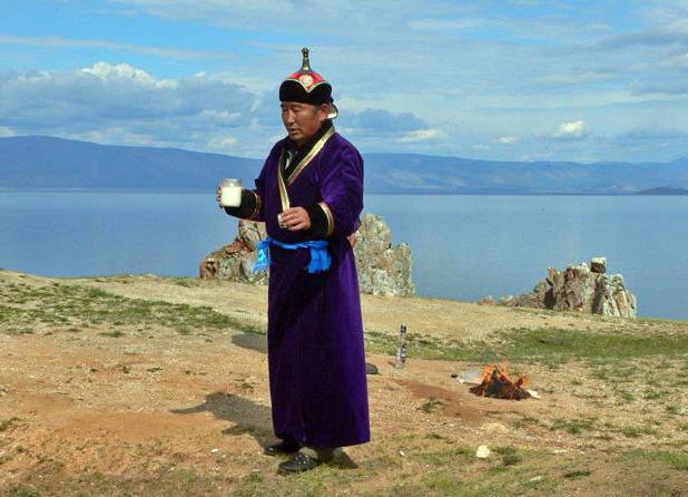
Buryatia today
Modern Buryatia is a republic within Russia. She has all the necessary attributes of state power, such as a flag, emblem and anthem. In addition, the Declaration of State Sovereignty was in effect until recently.
From the point of view of the law on the administrative structure, Buryatia is divided into twenty-one municipal districts and two cities of national significance. The official language of Buryatia, along with Russian, is Buryat. This provision is enshrined in the Constitution of the Republic.
The republic is one of the most urbanized in the Russian Federation, since the vast majority of the population of Buryatia lives in cities, of which there are six. The largest cities with a population of more than twenty thousand people include: Ulan-Ude, Kyakhta, Gusinoozersk and Severobaikalsk. The capital of the republic is the city of Ulan-Ude, the population of which exceeds four hundred and thirty-one thousand people. It is the main industrial and economic center of the republic.
Time in Buryatia is five hours ahead of Moscow, which means that the republic is in the UTC + 8 time zone.
Government
State power in the republic is exercised by the Head of Buryatia, the Government, the courts, as well as the People's Khural of the Republic of Buryatia, which exercises legislative power, being a representative body of people's power.
The People's Khural of the Republic of Buryatia consists of 66 deputies who are elected using a mixed system that includes both single-member constituencies and party lists.
In its modern form, the People's Khural has existed since 1994, when it was created on the basis of the executive committee of the Buryat ASSR. During the twenty-three years of its existence, the Khural was convened five times. The competence of this state body includes the preparation and discussion, as well as the initiation of legislative acts that affect all areas of public life, such as security, health and the economy.

The structure of the economy of Buryatia
Despite the small population, Buryatia is one of the subjects of the federation, the economy of which has developed in accordance with regional and climatic conditions.
In accordance with the level of its economic development, the republic occupies the sixtieth place among other regions of Russia, located between the Novgorod region and the Nenets Autonomous Okrug.
The main enterprises that produce the republic's gross product are located in the capital of Buryatia - the city of Ulan-Ude. For example, the Locomotive Repair Plant, as well as the Aircraft and Instrument-Making Plants are located in the capital. In addition, there are numerous transport, communications and energy enterprises in the city.
The most developed branch of the Buryat economy - the service sector - is best represented in the capital of the republic. Of the entire population of Buryatia, more than half live in Ulan-Ude, so it is not surprising that the main end-user-oriented enterprises are concentrated here.
Culture of the region
Despite the fact that, in accordance with the plan for the creation of national autonomies, which was implemented during the first years of the existence of the USSR and the pattern of territories for the creation of state entities, the overwhelming majority of the population of the republic are Russians.
In Buryatia, the population is represented by two large ethnic groups, the Buryats proper, who have lived on these lands for many centuries, and the Russians, who began active colonization of Transbaikalia at the end of the 15th century.
The development of the south of Eastern Siberia by Russian pioneers began with the construction of the Udinsky prison, which for a century served as one of the important fortifications in this region. It has been regularly rebuilt and modernized since it was twice besieged by Mongol tribes controlled by neighboring China. However, for a century and a half, most of the buildings in it were wooden.
Architectural heritage of Ulan-Ude
The first stone building was built in 1741. The same cathedral served as the point from which the new stone city began to rebuild.
For example, today's Lenina Street was the first street to connect Odigitrievsky Cathedral with Nagornaya Square, later renamed Sovetov Square, which today is the main square of Buryatia. Before the establishment of Soviet power in the republic, the street was called Bolshaya Nikolaevskaya.


