We suggest using a similar service from Google - + location of interesting places in the world on the Google Maps scheme
Calculation of the distance between two points by coordinates:
Online calculator - calculation of the distance between two cities, points. Their exact location in the world can be found at the link above.
Countries in alphabetical order:
Finding latitude and longitude on a map?
On the page, a quick determination of coordinates on the map - we find out the latitude and longitude of the city. Online search for streets and houses by address, using GPS, to determine the coordinates on the Yandex map, how to find the location is described in more detail below.
Determining the geographical coordinates of any city in the world (find out the latitude and longitude) using the online map from the Yandex service is actually a very simple process. You have two convenient options, let's take a closer look at each of them.
Fill out the form: Rostov-on-Don Pushkinskaya 10 (with the help of and if you have a house number, the search will be more accurate). In the upper right corner there is a form for determining the coordinates, which contains 3 exact parameters - the coordinates of the mark, the center of the map and the zoom scale.
After activating the "Find" search, each field will contain the necessary data - longitude and latitude. We look at the "Center of the map" field.
Second option: In this case, even easier. An interactive world map with coordinates contains a marker. By default, it stands in the center of the city of Moscow. It is necessary to drag the label and put it on the desired city, for example, we determine the coordinates on . The latitude and longitude will automatically match the search object. We look at the field "Label coordinates".
When searching for the city or country you need, use the navigation and zoom tools. By zooming in and out +/- , as well as moving the interactive map itself, it is easy to find any country, search for a region on the world map. Thus, you can find the geographical center of Ukraine or Russia. In the country of Ukraine, this is the village of Dobrovelichkovka, which is located on the Dobraya River, Kirovohrad Region.
Copy geographical coordinates of the center of Ukraine Dobrovelichkovka - Ctrl+C
48.3848,31.1769 48.3848 north latitude and 31.1769 east longitude
Longitude +37° 17′ 6.97″ E (37.1769)
Latitude +48° 38′ 4.89″ N (48.3848)
At the entrance to the urban-type settlement there is a sign informing about this interesting fact. Considering its territory is likely to be uninteresting. There are far more interesting places in the world.
How to find a place on the map by coordinates?
Consider the reverse process, for example. Why do you need to determine the latitude and longitude on the map? Suppose you need to determine the exact location of the car on the map using the coordinates of the GPS navigator. Or a close friend will call on the weekend and give you the coordinates of his location, inviting you to join the hunt or fish.
Knowing the exact geographical coordinates, you will need a map with latitude and longitude. It is enough to enter your data into the search form from the Yandex service in order to successfully determine the location by coordinates. Example, we enter the latitude and longitude of Moskovskaya street 66 in the city of Saratov - 51.5339,46.0368. The service will quickly determine and show the location of this house in the city as a marker.
In addition to the above, you can easily determine the coordinates on the map of any metro station in the city. After the name of the city, write the name of the station. And we observe where the label will be located and its coordinates with latitude and longitude. To determine the length of the route, it is necessary to use the "Ruler" tool (measurement of distances on the map). We put a mark at the beginning of the route and then at the end point. The service will automatically determine the distance in meters and show the track itself on the map.
It is possible to more accurately examine a place on the map thanks to the “Satellite” scheme (upper corner on the right). See what it looks like. You can do all of the above with it.
World map with longitude and latitude
Imagine you are in an unfamiliar area, and there are no objects or landmarks nearby. And there is no one to ask! How could you explain your exact location so that you can be found quickly?
Thanks to concepts such as latitude and longitude, you can be discovered and found. Latitude shows the location of an object in relation to the South and North Poles. The equator is considered to be zero latitude. The South Pole is located at 90 degrees. south latitude, and North at 90 degrees north latitude.
These data are not enough. It is also necessary to know the situation with respect to East and West. This is where the longitude coordinate comes in handy.
Thank you for the provided data service Yandex. Cards
Cartographic data of cities in Russia, Ukraine and the world
Similar coordinates apply on other planets, as well as on the celestial sphere.
Latitude
Latitude- angle φ between the local direction of the zenith and the plane of the equator, counted from 0° to 90° on both sides of the equator. The geographical latitude of points lying in the northern hemisphere (northern latitude) is considered to be positive, the latitude of points in the southern hemisphere is negative. It is customary to speak of latitudes close to the poles as high, and about those close to the equator - as about low.
Due to the difference in the shape of the Earth from the ball, the geographic latitude of the points is somewhat different from their geocentric latitude, that is, from the angle between the direction to a given point from the center of the Earth and the plane of the equator.
The latitude of a place can be determined using astronomical instruments such as a sextant or gnomon (direct measurement), you can also use GPS or GLONASS systems (indirect measurement).
Related videos
Longitude
Longitude- dihedral angle λ between the plane of the meridian passing through the given point, and the plane of the initial zero meridian, from which the longitude is counted. Longitude from 0° to 180° east of the prime meridian is called east, to the west - west. Eastern longitudes are considered to be positive, western - negative.
Height
To fully determine the position of a point in three-dimensional space, a third coordinate is needed - height. The distance to the center of the planet is not used in geography: it is convenient only when describing very deep regions of the planet or, on the contrary, when calculating orbits in space.
Within the geographic envelope, it is usually used height above sea level, counted from the level of the "smoothed" surface - the geoid. Such a system of three coordinates turns out to be orthogonal, which simplifies a number of calculations. Altitude above sea level is also convenient in that it is related to atmospheric pressure.
Distance from the earth's surface (up or down) is often used to describe a location, but "not" serves as a coordinate.
Geographic coordinate system
ω E = − V N / R (\displaystyle \omega _(E)=-V_(N)/R) ω N = V E / R + U cos (φ) (\displaystyle \omega _(N)=V_(E)/R+U\cos(\varphi)) ω U p = V E R t g (φ) + U sin (φ) (\displaystyle \omega _(Up)=(\frac (V_(E))(R))tg(\varphi)+U\sin(\ varphi)) where R is the radius of the earth, U is the angular velocity of the earth's rotation, V N (\displaystyle V_(N)) is the speed of the vehicle to the north, V E (\displaystyle V_(E))- to the East, φ (\displaystyle \varphi )- latitude, λ (\displaystyle \lambda )- longitude.
The main shortcoming in the practical application of the G.S.K. in navigation is the large values of the angular velocity of this system at high latitudes, which increase up to infinity at the pole. Therefore, instead of G. S. K., a semi-free SK in azimuth is used.
Semi-free in azimuth coordinate system
The semi-free in azimuth S.K. differs from the G.S.K. only by one equation, which has the form:
ω U p = U sin (φ) (\displaystyle \omega _(Up)=U\sin(\varphi))Accordingly, the system has the same initial position, carried out according to the formula
N = Y w cos (ε) + X w sin (ε) (\displaystyle N=Y_(w)\cos(\varepsilon)+X_(w)\sin(\varepsilon)) E = − Y w sin (ε) + X w cos (ε) (\displaystyle E=-Y_(w)\sin(\varepsilon)+X_(w)\cos(\varepsilon))In reality, all calculations are carried out in this system, and then, to issue output information, the coordinates are transformed into the GCS.
Recording formats for geographic coordinates
Any ellipsoid (or geoid) can be used to record geographic coordinates, but WGS 84 and Krasovsky (on the territory of the Russian Federation) are most often used.
Coordinates (latitude −90° to +90°, longitude −180° to +180°) can be written:
- in ° degrees as a decimal fraction (modern version)
- in ° degrees and ′ minutes with a decimal
- in ° degrees, ′ minutes and
There are many different coordinate systems. All of them are used to determine the position of points on the earth's surface. This includes mainly geographic coordinates, flat rectangular and polar coordinates. In general, it is customary to call coordinates angular and linear quantities that define points on a surface or in space.
Geographic coordinates are angular values - latitude and longitude, which determine the position of a point on the globe. Geographic latitude is the angle formed by the plane of the equator and a plumb line at a given point on the earth's surface. This angle value shows how far a particular point on the globe is north or south of the equator.
If the point is located in the Northern Hemisphere, then its geographical latitude will be called the northern latitude, and if in the Southern Hemisphere - the southern latitude. The latitude of points located on the equator is zero degrees, and at the poles (North and South) - 90 degrees.
Geographic longitude is also an angle, but formed by the plane of the meridian, taken as the initial (zero), and the plane of the meridian passing through the given point. For the uniformity of the definition, it was agreed to consider the meridian passing through the astronomical observatory in Greenwich (near London) as the initial meridian and call it Greenwich.
All points located to the east from it will have eastern longitude (up to the meridian of 180 degrees), and to the west of the initial one - western longitude. The figure below shows how to determine the position of point A on the earth's surface if its geographical coordinates (latitude and longitude) are known.
Note that the difference in longitudes of two points on Earth shows not only their relative position with respect to the zero meridian, but also the difference in these points at the same moment. The fact is that every 15 degrees (24th part of the circle) in longitude is equal to one hour of time. Based on this, it is possible to determine the difference in time at these two points by geographical longitude.
For example.
Moscow has a longitude of 37°37′ (East), and Khabarovsk -135°05′, that is, lies to the east of 97°28′. What time do these cities have at the same moment? Simple calculations show that if it is 13:00 in Moscow, then it is 19:30 in Khabarovsk.
The figure below shows the design of the sheet frame of any map. As can be seen from the figure, in the corners of this map, the longitude of the meridians and the latitude of the parallels that form the frame of the sheet of this map are signed.
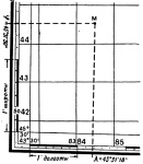
On all sides, the frame has scales divided into minutes. For both latitude and longitude. Moreover, each minute is divided by dots into 6 equal sections, which correspond to 10 seconds of longitude or latitude.
Thus, in order to determine the latitude of any point M on the map, it is necessary to draw a line through this point parallel to the lower or upper frame of the map, and read the corresponding degrees, minutes, seconds on the latitude scale to the right or left. In our example, point M has a latitude of 45°31’30”.
Similarly, drawing a vertical line through point M parallel to the lateral (closest to this point) meridian of the border of this sheet of the map, we read the longitude (east) equal to 43 ° 31'18 ".
Drawing a point on a topographic map according to given geographical coordinates.
Drawing a point on the map according to the given geographical coordinates is carried out in the reverse order. First, the indicated geographical coordinates are found on the scales, and then parallel and perpendicular lines are drawn through them. Intersecting them on will show the point with the given geographic coordinates.
Based on the book "The map and the compass are my friends."
Klimenko A.I.
In order to find the desired object on a map, you need to know its geographical coordinates - latitude and longitude.
Remember how you found a point on the coordinate plane in math lessons? In the same way, you can find any point on the planet using the system of parallels and meridians, or, as it is also called, the degree network.
First, set the geographic latitude of the point. That is, determine how far it is from the equator. To do this, calculate the value of the meridian arc from the equator to this point in degrees. Geographic latitude can vary from 0° to 90°. All points in the Northern Hemisphere have a northern latitude (abbreviated north latitude), and in the southern hemisphere they have a southern latitude (abbreviated south latitude).
Determination of geographical coordinates
To determine the geographic latitude of any point on the globe and map, you need to find out on which parallel it is located. For example, if Moscow is located on the parallel between 50° and 60° N. latitude, then its latitude is approximately 56 ° N. sh. All points of the same parallel have the same latitude. In order to establish the geographical longitude of a point, you need to find out how far it is from the initial (zero) meridian. It is conducted through the old building of the Greenwich Observatory, built in 1675 near London. This meridian is chosen conditionally as the zero meridian. It's called Greenwich. The magnitude of the arc of the parallel from it to a given point is measured in the same way as the geographic latitude - in degrees. If you move from the zero meridian to the east, then the longitude will be east (abbreviated east), and if you move west, west (abbreviated west). The value of longitude can be from 0° to 180°. To determine the geographical longitude of any point means to establish the longitude of the meridian on which it is located. So, Moscow is located at 38 ° E. Yes
It is possible to determine the location of a point on the planet Earth, as well as on any other planet of a spherical shape, using geographical coordinates - latitude and longitude. Right-angled intersections of circles and arcs create a corresponding grid, which makes it possible to uniquely determine the coordinates. A good example is an ordinary school globe lined with horizontal circles and vertical arcs. How to use the globe will be discussed below.
This system is measured in degrees (degree angle). The angle is calculated strictly from the center of the sphere to a point on the surface. Relative to the axis, the degree of the angle of latitude is calculated vertically, longitude - horizontally. To calculate the exact coordinates, there are special formulas, where one more value is often found - height, which serves mainly to represent three-dimensional space and allows calculations to determine the position of a point relative to sea level.
Latitude and longitude - terms and definitions
The earth's sphere is divided by an imaginary horizontal line into two equal parts of the world - the northern and southern hemispheres - into the positive and negative poles, respectively. This is how the definitions of northern and southern latitudes are introduced. Latitude is represented as circles parallel to the equator, called parallels. The equator itself with a value of 0 degrees is the starting point for measurements. The closer the parallel is to the upper or lower pole, the smaller its diameter and the higher or lower the angular degree. For example, the city of Moscow is located at 55 degrees north latitude, which determines the location of the capital as approximately equidistant from both the equator and the north pole.
Meridian - the so-called longitude, represented as a vertical arc strictly perpendicular to the circles of the parallel. The sphere is divided into 360 meridians. The reference point is the zero meridian (0 degrees), the arcs of which pass vertically through the points of the north and south poles and spread in east and west directions. This defines the angle of longitude from 0 to 180 degrees, calculated from the center to the extreme points to the east or south.
Unlike latitude, which is based on the equatorial line, any meridian can be zero. But for convenience, namely the convenience of counting time, the Greenwich meridian was determined.
Geographic coordinates - place and time

Latitude and longitude allow you to assign to a particular place on the planet an exact geographical address, measured in degrees. Degrees, in turn, are divided into smaller units, such as minutes and seconds. Each degree is divided into 60 parts (minutes), and each minute is divided into 60 seconds. On the example of Moscow, the record looks like this: 55° 45′ 7″ N, 37° 36′ 56″ E or 55 degrees, 45 minutes, 7 seconds north latitude and 37 degrees, 36 minutes, 56 seconds south longitude.
The interval between the meridians is 15 degrees and about 111 km along the equator - this is the distance the Earth rotates in one hour. It takes 24 hours for a full turn, which is a day.
Use the globe

The model of the Earth is accurately reproduced on a globe with a realistic rendering of all continents, seas and oceans. As auxiliary lines, parallels and meridians are drawn on the map of the globe. Almost any globe has in its design a sickle-shaped meridian, which is installed on the base and serves as an auxiliary measure.
The meridian arc is equipped with a special degree scale, which determines the latitude. Longitude can be found using another scale - a hoop, horizontally installed at the level of the equator. By marking the place you are looking for with your finger and rotating the globe around its axis towards the auxiliary arc, we fix the latitude value (depending on the location of the object, it will turn out to be either north or south). Then we mark the data of the equator scale at the place of its intersection with the meridian arc and determine the longitude. To find out whether it is east or south longitude, you can only relative to the zero meridian.