These gigantic drawings are distinguishable only with high altitude: only flying on an airplane over the Nazca plateau - that which is located in the southern part of Peru, you can see this "art gallery" on the ground, consisting of images of birds and animals, flowers and insects. The correct contours of the lizard, hummingbird, monkey, condor and spider are crossed by numerous straight lines, spirals, triangles, trapezoids and other geometric shapes.
Where did this heritage come from, what was the goal of the ancient artists who created desert masterpieces and, finally, what technologies allowed them to maintain the ideal proportions of the drawings, the size of the smallest of which is 46 meters, and the largest - the pelican - reaches 285 meters? These questions have occupied the minds of scientists since the very moment when the Nazca geoglyphs were discovered - since 1939, when an airplane with an American archaeologist on board flew over the desert.

The technique for making all the drawings is the same: the contour of the image is a single inseparable line that stretches for tens and hundreds of meters and often crosses hills, depressions and dried up river beds. Tell me, if you will, without the help of special instruments and control from a height, it was possible to draw all these straight lines, curves and broken lines, without once deviating from the given direction by even half a degree?

Yes, hundreds of meters - the lines of some geometric shapes stretch for 8 kilometers! Not being able to rise high above the “canvas”, it is more than difficult to get an idea of the nature of the drawing and, moreover, of the correctness of the direction taken. And that is not all. Careful studies of drawings and figures showed that all geoglyphs are subject to strict mathematical laws.

How were these canvases created? Like many other geoglyphs, by digging trenches: moving along a given contour, the ancient creators furrowed the desert land, digging the soil along the length of the entire pattern 120-140 cm wide and 25-35 cm deep. Due to the peculiarities of the semi-desert climate, the drawings of the Nazca board have survived to this day.

Another mystery that haunts researchers: how did it happen that the workers digging numerous trenches (recall that some lines are several kilometers long) did not leave any traces of their stay - at least trampled paths? By and large, pundits do not have exact answers to any of the current questions - only hypotheses.

Unless it was possible to determine the time of creation of drawings and lines relatively accurately - geoglyphs were formed before the 12th century, when the Incas settled the valley. This means that the authorship of marvelous patterns is attributed to the predecessors of the Incas - the Nazca civilization. One can only guess about the purpose of creating a "gallery" in the desert. Based on the fact that the huge paintings are distinguishable only from a great height, it is logical to assume that the ancient people who inhabited the desert tried to communicate with the deities in this way.

According to other versions, representatives of the Nazca civilization tried to reproduce the celestial map of the constellations using patterns and drawings or transmitted an encrypted message to someone. One of the idle assumptions is completely devoid of common sense: the signs allegedly inscribed on the face of the earth served as a landing strip for alien ships. One thing is clear: there are still much more questions in the case of geoglyphs of the Nazca plateau than answers - huge drawings in the middle of the desert remain an unsolved mystery to this day.
Do you know what a Nazca is? This is an ancient Indian civilization. It got its name from the river, in the valley of which one can still admire numerous cultural monuments. The heyday of this civilization was observed in the first millennium BC. Later, the name Nazca was worn by a small Indian village in the south of Peru, located behind the mountain ranges. In order to get to it from the capital of the state of Lima, it was necessary to drive many kilometers through a dusty, rocky and sandy wasteland.
Today, the city of Nazca is connected by a four-lane freeway. Moreover, that part of it, which passes through the bare hills and the desert, is paved with wild stones. A small and quiet village in the past, today it is a small but very neat town. It has its own museum and a small park, various shops and even two banks. There are hotels of various classes in the town that accept tourists who have gone to this area in order to get acquainted with the world-famous "Pampa de Nasca".
Geography
What attracts tourists from all over the world to a small town in southern Peru? Travelers come here to see the amazing and mysterious plateau Nazca. This is a plain, located on a certain hill. For her, as for all plateaus, a flat, and sometimes wavy relief is characteristic. It is slightly dissected in places. Distinct ledges separate the plateau from other plains.
Where is Nazca located? This plateau is located in the south of Peru. It is separated from the capital of the country, Lima, by 450 km, which must be overcome in a southeasterly direction. on the map is located almost in the coastal zone Pacific Ocean. From the plateau to its boundless waters - no more than eighty kilometers.
Nazca coordinates will help you find this area on the map faster. They are 14° 41′ 18″ south latitude and 75° 7′ 22″ West.
The Nazca plateau has an elongated shape from north to south. Its length is 50 km. But the width of the area from the western to the eastern borders ranges from five to seven kilometers.
natural conditions
The Nazca coordinates are such that the area is located in a dry climate zone. As a result, it is sparsely populated. Winter here lasts from June to September. For us, this is surprising, but in the Southern Hemisphere it does not coincide with that which is typical for the zone located north of the equator.
As for the air temperature, it is practically stable in this area. In the winter months, its value does not fall below sixteen degrees. In the summer, the thermometer is almost constantly kept at around +25.
The Nazca plateau, as mentioned above, is located in close proximity to the waters of the Pacific Ocean. However, despite this, rains are very rare here. There are no winds on the plateau either, since it is protected from air masses by mountain ranges. There are no rivers and streams in this desert either. You can see here only their dried-up beds.
Nazca lines
However, it is not its location that attracts many tourists to this region. The Nazca plateau beckons with mysterious drawings and lines located right on the earth's surface. Scientists call them geoglyphs. This concept means a geometric figure made in the earth's soil, the length of which is at least four meters.
The Nazca geoglyphs are grooves made of a mixture of sand and pebbles dug into the soil. They are not deep (15-30 cm), but long (up to 10 km), having different widths (from 150 to 200 m). Geoglyphs, or, as they are also called, the Nazca lines, are made in a very bizarre form. Here you can see the outlines of birds, spiders and animals, as well as geometric shapes. In total, there are about 13 thousand such lines on the plateau.

What is this? Secrets of history? Mysteries of the past? There is no single answer to these questions. Some scientists believe that the Nazca drawings are applied to the earth's surface by skillful human hands. However, it is still impossible to confirm this assumption. There is another, rather stable opinion, according to which the stripes and lines were applied not by people, but by representatives of an alien mind. This is the greatest secret of the Nazca desert, over which dozens of scientists are struggling. However, despite this, the mystery of the Peruvian plateau remains unsolved for the modern world.
Discovery history
The Nazca Desert (Peru) is famous huge paintings located on the plateau. These drawings, created by unknown artists, belong to greatest achievements world culture and are an undoubted monument of art throughout our planet.
For the first time terrestrial giant paintings the pilots noticed in 1927. But the geoglyphs of Nazca became known to the scientific community only twenty years later. It was then that the American historian Paul Kosok published a whole series of photographs of amazing and mysterious drawings that were taken from the air.
Creation technology
Nazca drawings were created by removing debris, brown stones and volcanic pebbles, covered with a thin coating of black, from a light subsoil, consisting of a mixture of calcite, clay and sand. That is why the contours of giant figures are clearly visible from a helicopter or plane.

From the air, all lines against the background of the soil look lighter, although from the ground or from low mountains such patterns merge with the ground, and it is impossible to distinguish them.
Lines and geometric shapes
All images that can be observed in the Nazca desert have a different shape. Some of them are stripes or lines, the width of which is in the range from fifteen centimeters to ten or more meters. Such deepenings of the soil are quite long. They can stretch from one to three or even more kilometers. The stripes can also expand smoothly along their length.
Some Nazca lines are elongated or truncated triangles. This is the most common view on the plateau. Moreover, their sizes are very diverse and range from one to three kilometers. Such triangles are often called trapezoids. Some Nazca drawings are large squares that have a rectangular or irregular shape.
You can also see such quadrangles familiar to us from geometry as trapezoids (with two parallel sides) on the plateau. There are about seven hundred such creations with clear forms in the desert.
Many lines and platforms have some deepening of the arcuate profile up to thirty or more centimeters. Moreover, all these grooves have clear boundaries, resembling a curb.
Feature of the Nazca lines
The geoglyphs of the Peruvian desert are widely known for their straightness. The imagination of travelers is literally amazed by the lines stretching for many kilometers along the plateau, easily overcoming all the features of the relief. In addition, the Nazca figures have peculiar centers, located, as a rule, on hills. At these points, different types of lines converge and diverge. Often, recesses in the ground are connected to each other, while combining in various combinations. It happens that shapes and lines overlap each other.
The location of the trapezoids is also interesting. Their bases, as a rule, are turned towards the river valleys and are located below the narrow part.
It is also surprising that:
- the edges of all lines have the highest accuracy, the spread of which is within only five centimeters over a length of several kilometers;
- the visibility of the contours is preserved even when the figures are superimposed on each other;
- there is a strict limitation of figures in width with significant lengths of the strips;
- the visibility of the stripes is maintained even with changes in the characteristics of the soil;
- there is a similarity of the configuration and arrangement of ray-shaped figures with optical schemes;
- the geometry of the figures is preserved even with complex terrain;
- there are lines that are astronomical in nature, indicating the cardinal points or the days of the equinoxes.
Various drawings
A kind of decoration of large-scale areas of the Nazca plateau are zigzags and whip-shaped figures. Among 13,000 lines, 800 platforms and hundreds of different spirals in the amazing and mysterious Peruvian desert, you can see semantic drawings. These are three dozen figures of animals and birds, including:
- a lizard 200 meters long, crossed by a ribbon of an American highway, the builders of which did not notice the drawing;
- a bird with a snake neck, stretching for 300 m;
- hundred meter condor;
- eighty meter spider.
In addition to these images, you can see fish and birds, a monkey and a flower, something similar to a tree, as well as a thirty-meter figure of a man, made not at all on a plateau, but as if carved on one of the steep slopes of a mountain.

From the ground, all these drawings are nothing but separate strokes and stripes. You can admire the giant images only by rising into the air. These greatest mysteries of history, the mysteries of the past, have not yet been clarified by scientists. How did an ancient civilization that does not have aircraft manage to create such complex drawings and what are their purposes?
Features of Nazca drawings
Contour images of birds and animals have different sizes, ranging from 45 to 300 m. The width of the contour line of the drawings is from 15 cm to 3 m. All semantic images that can be seen on the Nazca plateau are concentrated along its edge, located above the river valley Ingenio.
Among the features of these drawings are:
- execution of one continuous, nowhere intersecting and non-closing line;
- the beginning and end of the deepening of the soil are located on the site;
- the "output" and "input" of the circuits are two parallel lines;
- there is an ideal conjugation between curved drawings and straight lines, which, as established by scientists, are made according to the strict laws of mathematics, which explains their harmony and beauty;
- mechanical execution (except for the image of a monkey), which deprives the figures of animals of any emotional coloring;
- the presence of asymmetry, which is explained by the imperfection of the work on enlarging the sketches;
- the presence of secant lines parallel to one of the contour segments, which is explained by the complex execution of the internal space of the figure.
Assumptions and versions
Who is the author of the amazing creations located in the Nazca desert? So far, scientists can only build their own versions and put forward various hypotheses. So, there are many supporters of the assumption of the extraterrestrial origin of geoglyphs. They suggest that the wide lines served as runways for extraterrestrial civilization. However, such a hypothesis has many opponents who put forward their very weighty argument - the nature of the drawings. Yes, they are impressive and far from terrestrial in size, but their plot suggests that they were made by people, and not at all by aliens.

However, even in this case, many unresolved mysteries remain. How did unknown artists manage to create such gigantic images that are visible only from the air? Why did they do it? What techniques were used to keep the proportions of the giant models?
Hypotheses about the origin of drawings on the Nazca plateau are varied, and some of them are simply fantastic. However, among the existing versions there are those that deserve special attention.
So, according to some scientists, the entire system of Nazca lines is a huge calendar. One of the first to put forward this assumption was Paul Kosok. This American scientist was the first to discover the mysterious conglomeration of various shapes and lines. His whole life after that was devoted to unraveling the mystery of the Peruvian desert. Once Kosok noticed that the setting sun had set directly at the intersection of the horizon with one of the straight lines. He also discovered a band indicating a winter opposition. There is also Kosok's assumption that certain drawings correspond to certain cosmic bodies. This hypothesis has existed for a long time. Moreover, it was supported by many famous scientists from all over the world. However, later it was proved that the percentage of coincidence of the Nazca drawings with certain planets is extremely small in order to consider this system as a calendar.
There is another very plausible version. According to her, the Nazca lines indicate the location of an extensive system of underground water channels. This hypothesis can be confirmed by the fact that the location of ancient wells coincides with the strips dug in the ground. But it is possible that this is just a coincidence.

Or maybe the purpose of the Nazca lines is of a cult nature? Excavations of archaeologists have found ancient human burials and altars in places where drawings were made. However, all ritual objects have always been built in such a way that they can evoke certain emotions and influence a person. The drawings, viewed only from a height, do not evoke any feelings in those who are on the ground.

Be that as it may, the one who created these amazing figures had the ability to somehow move through the air and was remarkably oriented in space. Maybe ancient people knew how to build balloons and flew on them?
All existing hypotheses have not yet brought humanity closer to unraveling the mystery of the Nazca desert. Maybe soon scientists will answer the question about the origin of amazing lines? Or maybe this mystery will remain unsolved ...
The Nazca Plateau today is a lifeless desert, covered with stones darkened from heat and sun and indented by channels of long-dry water streams; one of the driest places on earth. It is located 450 km south of Lima, the capital of Peru, 40 km from the Pacific coast, at an altitude of approximately 450 m. It rains here on average once every two years and lasts no more than half an hour.

In the twenties, with the beginning of air travel from Lima to Arequipa, strange lines began to be noticed on the plateau. Lots of lines. Straight as an arrow, sometimes stretching to the very horizon, wide and narrow, intersecting and overlapping, combining into unthinkable patterns and flying out from the centers, the lines made the desert look like a giant drawing board:

Since the middle of the last century, a serious study of the lines and cultures that inhabited this region began, but the geoglyphs still kept their secrets; versions began to appear explaining the phenomenon outside the mainstream of academic science, the topic took its rightful place among the unsolved mysteries of ancient civilizations, and now almost everyone knows about the Nazca geoglyphs.
Representatives of official science have repeatedly stated that everything has been unraveled and deciphered, that these are nothing more than traces of religious ceremonies, or, in extreme cases, traces of searches for water sources or the remains of astronomical indicators. But just look at the pictures from an airplane, and preferably from space, as fair doubts and questions arise - what kind of rituals are these that forced Indians two thousand years ago, whose society was at the earliest stages of development, who did not have a written language, who lived in small villages and farmsteads, forced to constantly fight for survival, to draw hundreds of square kilometers of the desert with geometric shapes, many kilometers of straight lines and giant design images that can only be seen from a great height?
Maria Reiche, who has devoted more than 50 years to the study of geoglyphs, notes in her book that, given the enormous amount of work carried out, the creation of lines should have been the central task of the society that inhabited this area at that time ...
Although it is worth noting that in more specialized works, archaeologists do not adhere to such categorical conclusions about the complete solution of the lines, mentioning religious ceremonies only as the most likely version that requires further research.
And I propose to touch this amazing riddle again, but maybe a little more closely, as if from another dimension; to do similar to what P. Kosok did in 1939, when he first specially hired an airplane to fly over the desert.
So, some necessary information.
1927 Official discovery of the lines by the Peruvian archaeologist Toribio Meia Xespe.
1939 Geoglyph research begins by historian Paul Kosok of Long Island University in New York.
1946 - 1998 The study of geoglyphs by the German mathematician and archaeologist Maria Reiche. Arriving for the first time together with Paul Kosok as an interpreter, Maria Reiche continued the research of lines, which became the main work of her life. It is largely thanks to this courageous woman that the lines continue to exist and are available for research.
1960 Start of intensive study of geoglyphs by various expeditions and researchers.
1968 Erich Von Denikin's book "Chariots of the Gods" is published, where the version of the traces of extraterrestrial civilizations is expressed. The beginning of the wide popularity of the Nazca geoglyphs and the tourist boom on the plateau.
1973 Expedition of the English astronomer Gerald Hawkins (author of a monograph on Stonehenge), the results of which showed the inconsistency of the astronomical version proposed by P. Kosak and M. Reich.
1994 Thanks to the efforts of Maria Reiche, the Nazca geoglyphs are included in the UNESCO World Heritage List.
Since 1997, the Nasca Palpa project, led by the Peruvian archaeologist Joni Isla and prof. Markus Reindel of the German Archaeological Institute with the support of the Swiss-Liechtenstein Foundation for Foreign Archaeological Research. The main version based on the results of work since 1997 is the already mentioned ritual actions associated with the cult of water and fertility.
Currently, a GIS-geoinformation system is being created (digital 3-dimensional display of geoglyphs combined with archaeological and geological information) with the participation of the Zurich Institute of Geodesy and Photogrammetry.
A little about versions. The two most popular ones have already been mentioned (rituals of the Indians and traces of extraterrestrial civilizations):

To begin with, let's clarify the meaning of the term "geoglyphs" a little. According to Wikipedia, "a geoglyph is a geometric or figured pattern applied to the ground, usually over 4 meters long. There are two ways to create geoglyphs - by removing the top layer of soil around the perimeter of the pattern, or, conversely, pouring rubble where the pattern line should pass. Many geoglyphs are so large that they can only be seen from the air." It is worth adding that the vast majority of geoglyphs are quite unambiguously interpreted drawings or signs, and from ancient times to this day people have applied and apply geoglyphs for certain purposes - religious, ideological, technical, entertainment, advertising. In our time, thanks to technological progress, the application methods have improved significantly, and, ultimately, both the illuminated runway and artificial islands in the United Arab Emirates can be considered modern geoglyphs:

According to the above, the Nazca lines (the number of giant drawings is only a fraction of a percent of the number of lines and geometric figures) are not entirely correct to consider geoglyphs, due to the unknown purpose for which they were applied. After all, it doesn’t occur to anyone to consider geoglyphs, say, agricultural activities or a transport system, which from a great height also look like geometric patterns. But it so happened that in official archeology, and in popular literature Nazca lines and drawings are called geoglyphs. We will not break traditions.
1. LINES
Geoglyphs are found almost everywhere west coast South America. In this chapter, we will take a closer look at the geoglyphs in the Nazca region, and you will find information about other regions in the appendix.
On the next map, the areas marked in blue are where the lines are clearly readable in Google Earth and have a similar structure; red rectangle - "tourist place", where the density of lines is maximum and most of the drawings are concentrated; the purple area is the area of distribution of lines, considered in most studies, when they say "geoglyphs of Nazca-Palpa" they mean exactly this area. The purple icon in the upper left corner is the well-known geoglyph "Paracas Candelabra":

Red rectangle area:

Purple area:

The geoglyphs themselves are a rather simple thing - stones covered with a dark desert tan (manganese and iron oxides) were removed to the side, thereby exposing a light layer of subsoil, consisting of a mixture of sand, clay and gypsum:

But often geoglyphs have a more complex structure - deepening, an ordered border, stone structures, or simply heaps of stones at the ends of lines, which is why in some works they are called soil structures.
Where the geoglyphs enter the mountains, a lighter layer of rubble was exposed:

In this chapter, we will mainly consider that large part of geoglyphs, which includes lines and geometric shapes.
They are usually classified according to their shape as follows:
Lines and stripes from 15 cm to 10 or more meters wide, which can stretch for many kilometers (1-3 km are quite common, some sources mention 18 or more km). Most of the drawings are drawn with thin lines. The stripes sometimes gradually expand along their entire length:

Truncated and elongated triangles (the most common type of geometric figures on the plateau after lines) of various sizes (from 3 m to more than 1 km) - they are usually called trapezoids:

Large areas of rectangular and irregular shape:

Often the lines and platforms are deepened, according to M. Reiche up to 30 cm or more, the deepenings near the lines often have an arched profile:

This is clearly seen on almost filled trapezoids:

Or in a picture taken by a member of the LAI expedition:

The shoot place:

Lines almost always have well-defined borders - basically it is something like a border, very precisely maintained along the entire length of the line. But also the boundaries can be dumps of stones (for large trapezoids and rectangles, as in Fig. 15) or heaps of stones with varying degrees of order:

We note a feature due to which the Nazca geoglyphs became widely known - straightforwardness. In 1973, J. Hawkins wrote that some many-kilometer straight lines were made at the limit of photogrammetric possibilities. I don’t know how things are now, but you must admit that it’s not bad at all for the Indians. It should be added that often the lines go along the relief, as if not noticing it.

Examples that have become classic:


Airplane view:

The centers are clearly visible on map 6. Map of the centers compiled by Maria Reiche (small dots):

American researcher Anthony Eveny in his book "Between lines" mentions 62 centers in the Nazca Palpa area.
Often the lines are connected to each other and combined into various combinations. It is also noticeable that the work went on in several stages, often lines and shapes overlap each other:

It is worth noting the location of the trapezoids. The bases usually face the river valleys, the narrow part is almost always higher than the base. Although where the elevation difference is small (on flat hilltops or in the desert) this does not work:

A few words need to be said about the age and number of lines. It is generally accepted by official science that the lines were created between 400 BC and 400 BC. e. and 600 AD This is based on fragments of ceramics from different phases of the Nazca culture, which are found in dumps and heaps of stones on the lines, as well as radiocarbon analysis of the remains of wooden poles, which are considered marking. Thermoluminescent dating is also used, which shows similar results. We will touch on this topic further below.
As for the number of lines - Maria Reiche registered about 9,000 of them, at present a figure from 13,000 to 30,000 is mentioned (and this is only on the purple part of the map 5; no one counted similar lines at Ika and Pisco, although they obviously exist there far less). But it must be borne in mind that we see only what the time and cares of Maria Reich left us (now the Nazca plateau is a reserve), who mentioned in her book that before her eyes, areas with interesting lines and spirals are planted under cotton crops. Obviously, most of them were buried by erosion, sands and human activity, and the lines themselves sometimes cover each other in several layers, and they true number may differ by at least an order of magnitude. It makes sense to talk not about the number, but about the density of lines. And here it is worth noting the following.
Given that the climate, as archaeologists point out, was wetter during this period (and Google Earth also shows that the ruins and remains of irrigation facilities go deep into the desert), the maximum density of geoglyphs is observed near river valleys and settlements (Map 7). But you can meet individual lines both in the mountains and far in the desert:

At an altitude of 2000 m, 50 km west of Nazca:

A trapezoid from a group of lines in the desert 25 km from Ica:

And further. When compiling the GIS of some areas of Palpa and Nazca, it was concluded that, in general, all lines were built in places accessible to humans and what is happening on the lines (but not the lines themselves) can be seen from remote observation points. I don’t know about the second, but the first seems to be true for the vast majority of lines (there are inconvenient places, but I haven’t seen impassable ones), especially since Google Earth allows you to rotate the image this way and that (purple area on map 5):


The list of obvious features could go on, but perhaps it's time to move on to the details.
The first thing I would like to start with is a significant amount of work done, to put it mildly, not quite qualitatively:

Most of the pictures were taken within the purple area on map 5, which was the most invaded by tourists and all sorts of experimenters; according to Reiche, there were even military maneuvers here. I have tried to avoid as much as possible modern traces, especially since it is not difficult - they are lighter, go over the ancient lines and do not have traces of erosion.
A few more notable examples:


The ancients had strange rituals - would it be worth doing such a volume of marking and clearing work that you would then give up halfway through or even at the final part? Interestingly, sometimes on completely finished trapezoids, there are often heaps of stones, as if thrown or forgotten by the builders:

According to archaeologists, work on the construction and reconstruction of lines was carried out constantly. I will add that this is more likely to apply only to certain groups of lines located near Palpa and in the valley of the river Ingenio. There, all kinds of activity did not stop, perhaps even during the time of the Incas, judging by the numerous stone structures around the bases of the trapezoids:

Some such places are sometimes as if marked by anthropomorphic and rather primitive geoglyphic images, reminiscent of ordinary cave drawings(historians attribute them to the style of the Paracas culture, 400-100 BC, the predecessor of the Nazca culture). It is clearly seen that quite a few trampled there (including modern tourists):


I must say that such places are mostly preferred by archaeologists.
Here we come to one extremely interesting detail.
You noticed that I constantly mention heaps and stone structures - they made borders out of them, arbitrarily left on the lines. But there is another type of similar elements, as if included in the design of a significant number of trapezoids. Notice the two elements at the narrow end and one at the wide end:

The detail is important, so more examples:

In this Google image, several trapezoids have similar elements at once:

These elements are not the latest additions - they are present on some unfinished trapezoids, and are also found in all 5 regions indicated on the map. Here are examples from opposite ends - the first from the Pisco region, and two from the mountainous area east of Nazca. Interestingly, on the latter, these elements are also present inside the trapezoid:

Archaeologists have recently become interested in these elements, and here are descriptions of these structures on one of the trapezoids in the Palpa region (1):
Stone platforms with walls of stones bonded with mud mortar, sometimes double (the outer wall was made of the flat sides of the stone, giving splendor), filled with rock, among which there are fragments of ceramics and food remains; there was a raised floor made of rammed clay and stone inlays. It is assumed that wooden beams were laid on top of these structures and used as platforms.

The diagram shows pits between the platforms, where the remains of wooden (willow) poles, presumably massive, were found. Radiocarbon analysis of one of the pillars showed the age of 340-425 AD, a piece of a stick from a stone platform (another trapezoid) - 420-540 AD. e. Also, pits with the remains of pillars were found on the borders of the trapezoids.
Here is a description of a ring structure found near the trapezoid, which, according to archaeologists, is similar to those found at the base of the trapezoid:
According to the method of construction, it is similar to the platforms described above, with the difference that the inner part of the wall was also given splendor. It had the shape of the letter D, a gap was made on the flat side. A flat stone, placed after reconstruction, is visible, but it is noted that there was a second one, and both were used as supports for the stairs to the platform.

In most cases, these elements did not have such a complex structure and were simply heaps or ring structures of stones, and a single element at the base of the trapezoid could not be read at all.

And more examples:


We dwelled on this point in a little more detail, because it is quite obvious that the platforms were built together with the trapezoids. They can be seen very often in Google Earth, and ring structures are very well distinguishable. And it is unlikely that the Indians were specifically looking for trapezoids in order to build platforms on them. Sometimes even the trapezoid is barely guessed, and these elements are clearly visible (for example, in
desert 20 km from Ica):

The large rectangular areas have a slightly different set of elements - two large piles of stones, located one at each edge. Perhaps one of them is shown in documentary National Geographic "Nazca Lines. Deciphered":

Well, a sure point in favor of the rituals.
Based on our orthodox version, it is logical to assume that there must be some kind of markup. Something similar really exists and is very often used - a thin central line running along the center of the trapezoid and sometimes going far beyond. In some works of archaeologists, it is sometimes called the axial line of the trapezoid. Usually it is tied to the platforms described above.
(begins or passes near-through the platform at the base, and always exits exactly in the middle between the platforms at the narrow end), the trapezoid may not be symmetrical with respect to it (and the platforms, respectively):

This is true for all selected areas of map 5. The trapezoid from Iki is indicative in this respect. 28, the center line of which seems to shoot a line of heaps of stones.
Examples different types trapezoid and strip markings, as well as various types of work on them in the purple area (we called them mattresses and perforated tapes):


The markup in some of the examples shown is no longer a simple delineation of the main axes and contours. Here there are elements, as it were, of scanning the entire area of the future geoglyph.
This is especially noticeable on the markings for large rectangular sites from the "tourist place" near the Ingenio River:
Under the platform:

And here, next to the existing site, another one was marked out:

A similar markup for future sites on the layout of M. Reiche is well read:

Let's take note of the "scanning markup" and move on.
Interestingly, the markers and those who carried out the clearing work sometimes seemed to be unable to coordinate their actions to a sufficient degree:


And an example of two large trapezoids. I wonder if this is how it was intended, or someone messed something up:
Given all of the above, it was hard not to take a closer look at the actions of the markers.
And here we are waiting for some more extremely entertaining details.
To begin with, I will say that it is very significant to compare the behavior of modern transport and ancient markers using a thin line. Traces of cars and motorcycles run unevenly along one direction, and it is difficult to find straight sections of more than a couple of hundred meters. At the same time, the ancient line is always almost straight, often moving inexorably for many kilometers (checked in Google with a ruler), sometimes disappearing, as if breaking away from the ground, and reappearing in the same direction; occasionally can make a slight turn, sharply or not very change direction; and in the end either rests on the center of intersections, or smoothly disappears, dissolving into a trapezoid that crosses lines or with a change in relief.
Often markers seem to rely on heaps of stones located next to the lines, and less often on the lines themselves:

Or this example:

I have already spoken about straightforwardness, but I will note the following.
Some lines and trapezoids, even distorted by relief, become straight from a certain point of view from the air, which has already been noted in some studies. For example. The line, slightly walking in the satellite picture, looks almost straight from the viewpoint, located a little to the side (frame from the documentary "Nazca Lines. Deciphered"):

I am not an expert in the field of geodesy, but, in my opinion, to draw a line on rough terrain along which an inclined plane intersects the relief is a rather difficult task.
Another similar example. Airplane photo on the left, satellite photo on the right. In the center is a fragment of an old photo of Paul Kosok (taken from the lower right corner of the original photo from the book by M. Reiche). We can see that the whole combination of lines and trapezoids seems to be drawn from a point close to the point from which the central picture was taken.

And the next photo is better viewed in good resolution (here - Fig. 63).

First, let's pay attention to the under-cleared area in the center. The ways of working by hand are very clearly presented - there are both large and small heaps, gravel heaps at the borders, an irregular border, not very organized work - they collected it here and there and left. In short, everything that we saw in the section on manual work.
Now let's look at the line that crosses the left side of the photo from top to bottom. A radically different style of work. The ancient aces-builders seem to have decided to imitate the work of a chisel fixed at a certain height. With a jump across the stream. Rectilinear and regular borders, leveled bottom; they didn't even forget to reproduce the subtleties of breaking off the trace of the upper part of the line. There is a possibility that this
water or wind erosion. But there are enough examples of all kinds of environmental influences in photographs - it does not look like either one or the other. Yes, and on the surrounding lines it would be noticeable. Here, rather, a deliberate interruption of the line by about 25 meters. If we add a concave profile of the line, as in old photographs or from a photo in the Palpa region, and tons of rock to be shoveled (the line width is about 4 m), then the picture will be complete. Also indicative are four perpendicular thin parallel lines, clearly applied on top. If you look closely, you can see that the depth of the lines also changes on uneven terrain; it looks like a trace drawn along a ruler with a metal fork over a piece of plasticine.
For myself, I called such lines t-lines (lines made with the help of technology, i.e. taking into account the use of special methods for marking, performing and controlling work). Similar features have already been noted by some researchers. Photos of similar lines are on the site (24) and similar behavior of some lines (interruption of lines and interaction with the relief) is noted in the article (1).
A similar example, where you can also compare the level of work (two "rough" lines are marked with arrows):

What is remarkable. The unfinished rough line (the one in the center) has a thin marking line. But the markings for t-lines have never been seen. As well as unfinished t-lines.
Here are some more examples:


According to the "ritual" version, the lines had to be walked. One Discovery documentary showed the internal compacted structure of the lines, presumably due to intense walking on them (the compaction of the rock explains the magnetic anomalies recorded on the lines):

And in order to trample on like that, they had to walk a lot. Not just a lot, but a lot. It is only interesting how the ancients determined the routes in Fig. 67 to tread down the lines approximately evenly? And how did you jump 25 meters?
It is a pity that the photos with sufficient resolution cover only the "tourist" part of our map. So from other areas we will be content with maps from Google Earth.
Rough work at the bottom of the picture and the t-line at the top:

And these t-lines stretch in a similar way for about 4 km:

T-lines were able to make turns:

And such a detail. If we return to the t-line, which we discussed the very first, and look at its beginning, we will see a small expansion, resembling a trapezoid, which then develops into a t-line and, very smoothly changing width and abruptly changing direction four times, crosses itself , and dissolves into a large rectangle (the unfinished platform is obviously of a later origin):

Sometimes there was some kind of failure in the work of the markers (curves with stones at the end of the strips):

There are also large trapezoids, similar to the work of markers. For example. A well-made trapezoid with borders-borders, as it were, grows by pushing the borders out of the dent line of the marker:

Another interesting example. A fairly large trapezoid (in the picture, about two-thirds of the entire length), made as if by pushing the cutting edges of the "cutter", and in the narrow part one of the edges ceases to touch the surface:
There are enough oddities like this. All discussed area of our map for the most part, seems to represent the creativity of those same markers, well mixed with rough, unskilled work. Archaeologist Haylen Silverman once compared the plateau to a striated school board at the end of a busy school day. Very well marked. But I would add something about joint classes preschool group and graduate students.
There are attempts to make the lines by hand in our time available to the ancient Naskans by means:

The ancients did something similar, and perhaps in precisely these ways:

But in my opinion, t-lines resemble something else. They are more like a trace of a spatula, with which they imitated the Nazca drawings in one of the documentaries:

And here is a comparison of t-lines and a trace of a stack on plasticine:

Something like this. Only a spatula or a stack they had a little more ...
And the last. A note about markers. There is such a recently opened religious center of the ancient Naskans - Cahuachi. It is believed that it is directly related to the construction of lines. And if we compare, on the same scale, this very Cahuachi with a section of the desert lined a kilometer away, the question arises - if the Nascan surveyors themselves painted the desert, then they invited Cahuachi to mark out
guest workers from backward hill tribes?

Draw a clear line between unskilled work and t-lines and draw any conclusions using only photographs of the "tourist" area and google maps earth is impossible. It is necessary to look and study on the spot. And since the chapter is devoted to material that claims to be factual, I will refrain from commenting on such sophisticated rituals; and therefore we end the discussion of t-lines and proceed to the final part of the chapter.
Line combinations
The fact that lines form certain groups and combinations has been noted by many researchers. For example, prof. M. Reindel called them functional units. A few clarifications. Combinations are understood not as a simple superimposition of lines on each other, but as if unification into one whole through common boundaries or obvious interaction with each other. And in order to try to understand the logic of creating combinations, I propose to start by systematizing the set of elements that the builders used. And, as we can see, there is not much diversity here:

There are only four elements. Trapezoids, rectangles, lines and spirals. There are also drawings, but a whole chapter is devoted to them; here we will consider them a kind of spirals.
Let's start from the end.
Spirals. This is a fairly common element, there are about a hundred of them and they are almost always included in line combinations. There are very different ones - perfect and not quite, square and intricate, but always double:

The next element is lines. Basically, these are our familiar t-lines.
Rectangles - they were also mentioned. Let's just note two things. First. There are relatively few of them and they always try to be oriented perpendicular to the trapezoid and gravitate towards their narrow part, sometimes as if crossing them out (Map 6). Second. In the valley of the Nazca River there is a significant number of large broken rectangles, as if superimposed on the beds of dried up rivers. On the drawings, they are indicated mainly in yellow:
The boundary of such a site is clearly visible in Fig. 69 (bottom).
And the last element is a trapezoid. Along with lines, the most common element on the plateau. A few details:

1 - Location relative to stone structures and types of borders. As already noted, very often stone structures are poorly readable, or they do not exist at all. There is also some functionality of trapezoids. I don't want to militarize the description, but the analogy with small arms comes to mind. The trapezoid, as it were, has a muzzle (narrow) and breech, each of which interacts quite standardly with other lines.
For myself, I divided all combinations of lines into two types - collapsed and expanded. The trapezoid is the main element in all combinations. Curled (group 2 in the diagram) is when the line emerges from the narrow end of the trapezoid at an angle of about 90 degrees (or less). This combination is usually compact, the thin line often returning to the base of the trapezoid, sometimes with a spiral or pattern.
Reversed (group 3) - the outgoing line almost does not change direction. The simplest expanded one is a trapezoid with a thin line, as if shooting from a narrow part and stretching for a considerable distance.
Another couple important details before moving on to examples. In folded combinations, there are no stone structures on the trapezoid, and the base (wide part) sometimes has a series of lines:

It's clear that the last row in the last example, laid out by caring restorers. Snapshot of the last example from the ground:

In deployed ones, on the contrary, very often there are stone structures, and the base has an additional trapezoid or trapezoids of a much smaller size, joining (in series or in parallel) to the place of a single platform (possibly taking it outside the main one):


For the first time, a folded combination of lines was described by Maria Reiche. She called her "whip":

From the narrow end of the trapezoid acute angle in the direction of the base there is a line, which, as if scanning the surrounding space (in this case, the features of the relief) in a zigzag, turns into a spiral in the immediate vicinity of the base. Here is the twisted combination. We substitute different variations of these elements and get a very common combination in the Nazca Palpa region.
An example with another zigzag option:
More examples:

Examples of larger and more complex folded combinations in characteristic interaction with a rectangular pad:

On the map, multi-colored asterisks show well-read folded combinations in the Palpa-Nasca area:
A very interesting example of a group of folded combinations is shown in the book by M. Reiche:

To a huge folded combination, to the narrow part of the trapezoid, a micro-combination is attached, as it were, having all the attributes of an ordinary folded combination. A more detailed photo shows: white arrows - breaks of the zigzag, black - the mini-combination itself (the large spiral near the base of the trapezoid is not shown by M. Reiche):

Examples of folded combinations with pictures:

Here you can note the order in which combinations are created. The question is not completely clear, but many examples show that the scanning lines seem to see the parent trapezoid and take it into account with their trajectory. On a combination with a monkey - a sawtooth zigzag, as it were, fits between the existing lines; much more difficult from the point of view of the artist would be to draw him first. Yes, and the dynamics of the process - first a trapezoid with a garden of various details, then a thinning t-line, turning into a spiral or pattern, and then disappearing altogether - in my opinion, is more logical.
Introducing the folded combination champion. The length of only the visible continuous and very high-quality part (a combination of lines near Cahuachi) is more than 6 km .:

And here you can see the scale of what is happening - Fig. 81 (drawing by A. Tatukov).
Let's move on to expanded combinations.
There is no such relatively clear construction algorithm here, except for the fact that these combinations cover a significant area. One might even say that it is more different ways interaction of lines and groups of lines with each other. See examples:

Trapezoid 1, which, in turn, has a small "ignition" trapezoid, rests with a narrow part on a hill, on which, as it were, an "explosion" occurs, or a connection of lines coming from the narrow ends of other trapezoids (2, 3).
Remote trapezoids seem to be connected to each other. But there is also a serial connection (4). Moreover, sometimes the connecting center line can change the width and direction. Purple marked unskilled work.
Another example. Interaction of an axial line with a length of about 9 km and 3 trapezoids:

1 - upper trapezoid, 2 - middle, 3 - lower. You can see how the axial one reacts to trapezoids, changing direction:
Next example. For greater clarity, it would be better to consider it in detail in Google Earth. But I'll try to explain.

Trapezoid 1, very roughly made, to which trapezoid 2 “shoots” at the narrow part, is connected to the base of trapezoid 3 (Fig. 103), which in turn “shoots” with a well-made line into a small hill. Here is such a trapezology.

In general, such shooting at distant low hills (it also happens at distant mountain peaks) is quite a common thing. According to archaeologists, about 7% of the lines are aimed at hills. For example, trapezoids and their axes in the desert near Ika:

And the last example. Combining a common border using rectangular pads of two large collapsed combinations:

It can be seen how the trapezoid, which shoots in a straight line, is deliberately ignored.
Here is a brief summary of all that I would like to say about combinations.
It is clear that the list of such compounds can be continued and developed for a very long time. At the same time, in my opinion, it would be wrong to think that the plateau is one big mega-combination. But the conscious and intentional association of some geoglyphs into groups according to certain characteristics and the existence of something like a common strategic plan for the entire plateau is beyond doubt. It is worth noting that all the deployed combinations mentioned occupy an area of several square kilometers each, and you cannot build such a thing in a day or two. And if you take into account all these t-lines, correct boundaries and platforms, kilotons of stones and rocks, and the fact that the work was carried out according to the same schemes throughout the entire area of \u200b\u200bthe mentioned region (map 5 - more than 7 thousand square kilometers), over a long period of time and sometimes in very unfavorable conditions, unpleasant questions arise. It is difficult to judge to what extent a society of culture
The Nazca was able to do this, but the fact that this required very specific knowledge, maps, tools, serious organization of work and large human resources is obvious.
2. DRAWINGS
Phew, with the lines, it seems, finished. For those who did not fall asleep from boredom, I promise - it will be much more fun. Well, there are birds, little animals, all sorts of spicy details ... Otherwise, all the sand is stones, stones are sand ...
Well, let's start.
Nazca drawings. The smallest, but the most famous part of the activities of the ancients on the plateau. To begin with, a little explanation of what kind of drawings will be discussed below.
According to archaeologists, man appeared in these places (the Nazca-Palpa region) quite a long time ago - several millennia before the formation of the Nazca and Paracas cultures. And all the while people were leaving various images, which have been preserved in the form of petroglyphs, drawings on ceramics, textiles and well-marked geoglyphs on the slopes of mountains and hills. It is not in my competence to delve into all sorts of chronological and iconographic subtleties, especially since there are enough works on this topic now. We'll just look at what these people drew; and not even what, but how. And as it turned out, everything is quite natural. In Fig.106, the upper group is the earliest and most primitive petroglyphs (rock paintings); lower - images on ceramics and textiles of the Nazca - Paracas cultures. The middle row is geoglyphs. There is a lot of such creativity in this region. The sombrero-like detail on the head is actually a headpiece (usually gold Fig. 107), as I understand it, some kind of insignia used in these parts and is very common in many images.
All such geoglyphs are located on slopes, are clearly visible from the ground, made in one way (clearing stones from sites and using heaps of stones as details) and quite in the style of the lower and upper rows. In general, there are enough similar activities around the world (1st column of Fig. 4).
We will be interested in other drawings, as we will see below, in many ways different from those described above in style and method of creation; which, in fact, are known as Nazca drawings.
There are just over 30 of them. There are no anthropomorphic images among them (primitive geoglyphs, described above, in the vast majority depict people). The sizes of the drawings are from 15 to 400(!) meters. Drawn (Maria Reiche mentions the term "scratched") with one line (usually a thin marking line), which often does not close, i.e. the drawing has, as it were, an entrance-exit; sometimes included in a combination of lines; most of the drawings are visible only from a considerable height:

Most of them are located just in the "tourist" place, near the river Ingenio. The appointment and evaluation of these drawings are controversial even among representatives of official science. Maria Reiche, for example, admired the refinement and harmony of the drawings, and the participants in the modern Nazca project
Palpa" under the guidance of Prof. Markus Reindel believe that the drawings were not conceived as images at all, but were created only as directions for ritual processions. There is no clarity, as usual.
I suggest not to be loaded with introductory information, but immediately delve into the topic.
In many sources, especially official ones, the issue of drawings belonging to the Nazca culture is a settled issue. For the sake of fairness, it should be noted that in sources with an alternative focus, this topic is generally silent. Official historians usually refer to comparative analysis drawings in the desert and the iconography of the Nazca culture, made by William Isbel back in 1978. Unfortunately, I didn’t find work, I had to climb myself, since it’s not 78 now.
Drawings and photos of ceramics and textiles of the Nazca and Paracas cultures are now enough. I have mostly used the excellent collection of drawings made by Dr. C. Klados, available on the FAMSI website (25). And here's what turned out. Here is the case when it is better to look than to speak.
Fish and Monkey:

Hummingbird and Frigate:
Another hummingbird with a flower and a parrot (as the depicted character is usually called), which, perhaps, is not a parrot at all:

Well, the remaining birds: condor and harpies:

The fact, as they say, is obvious.
It is obvious that the drawings on textiles and ceramics of the Nazca and Paracas cultures and images in the desert sometimes coincide in detail. By the way, there was also a plant depicted on the plateau:

This manioc, or yucca, has been one of the staple foods in Peru since antiquity. And not only in Peru, but throughout the tropical zone of our planet. Like our potatoes. To taste too.
At the same time, it is worth noting that there are drawings on the plateau that have no analogues in the Nazca and Paracas cultures, but more on that later.
Well, let's see how the Indians created these wonderful images of theirs. There are no questions regarding the first group (primitive geoglyphs). The Indians were quite capable of doing this, given that there is always the opportunity to admire the creation from the outside, and, in which case, correct it. But with the second (drawings in the desert), some questions arise.
There is such an American researcher Joe Nickell, a member of the society of skeptics. And once he decided to reproduce one of the Nazca drawings - a 130-meter condor - in a field in Kentucky, USA. Joe and five of his assistants were armed with ropes, pegs and a cross of boards, allowing them to draw a perpendicular. All these "devices" could well have been among the inhabitants of the plateau.
The "Indians" team set to work on the morning of August 7, 1982 and completed it 9 hours later, including a lunch break. During this time, they marked 165 points and connected them together. Instead of digging, the testers covered the contours of the figure with lime. Photographs were taken from an aircraft flying at an altitude of 300 m.
“It was a success,” Nickell recalled. “The result was so accurate and accurate that we could easily recreate a much more symmetrical drawing in this way. It seems that the Nazca people marked out far fewer dots than we did, or used a rougher method, measuring distance, for example, with steps, and not with a rope" (11).
Yes, indeed, it turned out very similar. But then we agreed to take a closer look. I propose to compare the modern condor with the creation of the ancients in more detail:

It looks like Mr. Nickell (his condor on the left) got a little excited about judging his own work. A remake is walking. In yellow, I marked roundings and axes, which the ancients undoubtedly took into account in their work, and Nickell did it, as it turned out. And the proportions, slightly swollen because of this, give the drawing on the left some "clumsiness", which is absent in the ancient image.
And here comes the next question. To reproduce the condor, Nickell appears to have used a photograph as a sketch. When the image is enlarged and transferred to the surface of the earth, errors will inevitably occur, the magnitude of which depends on the method of transfer. These errors will be expressed, respectively, in all sorts of "clumsies" that we observed in Nickell (which, by the way, are present on some modern geoglyphs from the middle column of Fig. 4). And a question. And what sketches and methods of transfer did the ancients use to get almost perfect images?
It can be seen that the image, in this case the spider, is deliberately devoid of full symmetry, but not in the direction of an uncontrollable loss of proportions due to the imperfection of the transfer, as in Nickell's, but in the direction of giving liveliness to the drawing, the comfort of perception (which greatly complicates the transfer process). One gets the impression that the ancients had no problems at all with the quality of the transfer. It should be added that Nickell fulfilled his promise to create a more accurate image, and drew the same spider (frames from the National Geigraphic documentary "Is it Real? Ancient Astronauts"):

But you and I see that he drew his own spider, very similar to the Nascan and the same size, but simpler and symmetrical (for some reason, the photo from the plane could not be found anywhere), devoid of all the subtleties that are visible in the previous photos and which so admired Maria Reiche.
Let's put aside the often discussed question about the method of transferring and enlarging the drawings, and try to look at the sketches, without which the ancient artists could hardly have done.
And then it turned out that there are practically no better drawings that Maria Reiche made by hand in the middle of the last century. All that is there is either a stylization, without taking into account details, or a deliberate distortion of the drawings, showing, according to the artists, the primitive level of the Indians of that time. Well, I had to sit down and try to do it myself. But the case turned out to be so exciting that I could not tear myself away until I had drawn all the available images. Looking ahead, I will say that there were a couple of pleasant surprises. But before inviting you in
gallery of "Nasca" graphics, I would like to note the following.
At first, I did not quite understand what made Maria Reiche so carefully search for a mathematical description of the drawings:
And this is what she wrote in her book: “The length and direction of each segment were carefully measured and recorded. Approximate measurements would not be enough to reproduce such perfect outlines that we see with aerial photography: a deviation of just a few inches would distort the proportions of the picture. Photographs taken in this way help to imagine how hard it was for the ancient craftsmen.The ancient Peruvians must have possessed equipment that even we do not have and which, combined with ancient knowledge, was carefully hidden from the conquerors, as the only treasure that cannot be kidnap" (2).
I fully understood this when I started drawing. It was no longer about sketches, but about getting close enough to what is on the plateau. Any minimal shift in proportions almost always resulted in "clumsiness", similar to what we saw with Nickell, and immediately lost the lightness and harmony of the image.
A little about the process. There is enough photographic material for all the drawings, if some detail was missing, you can always find the right picture from a different angle. Sometimes there were problems with perspective, but this was solved either with the help of existing drawings, or with a snapshot from Google Earth. This is how the working moment looks when drawing the "snake" (in this case, 5 photos were used):
And then, at one fine moment, I suddenly discovered that with a certain skill in working with Bezier curves (developed in the 60s for automotive design and which became one of the main tools for computer graphics), the program sometimes drew contours quite similarly. At first it was noticeable on the fillets of the legs of the spider, when without my participation these fillets became almost identical to the original ones. Further, with the correct positions of the nodes and when they were combined into a curve, the line sometimes almost exactly repeated the contour of the picture. And the fewer nodes, but the more optimal their position and settings, the more similarity with the original.

In general, a spider is practically one Bezier curve (more correctly, a Bezier spline, a sequential connection of Bezier curves), without circles and straight lines. With further work, a feeling arose that grew into confidence that this unique "Nascan" design is a combination of Bezier curves and straight lines. There were almost no regular circles or arcs:
Is it not Bezier curves that Maria Reiche, a mathematician by training, tried to describe by making numerous measurements of radii?
But I was truly imbued with the skill of the ancients when drawing large drawings, where almost ideal curves of huge sizes met. Let me remind you once again that the purpose of the drawings was an attempt to look at the sketch, at what the ancients had before drawing on the plateau. I tried to minimize my own creativity, resorting to painting damaged places only where the logic of the ancients was obvious (for example, the tail of a condor, a falling out and clearly modern rounding on the body of a spider). It is clear that there is some idealization, improvement of the drawings, but one should also not forget that the originals are gigantic, more than once restored images in the desert, which are at least 1500 years old.
Let's start with a spider and a dog without technical details:
Fish and bird frigate:
A little more about the monkey. This drawing has the most uneven outline. First, I drew it the way it looks in the pictures:

But then it became clear that with all the accuracy of observing the proportions, the artist's hand seemed to be trembling a little, which is also noticeable on straight lines belonging to the same combination. I do not know what it is connected with, perhaps with a very uneven terrain in this place; but if the line on the sketch is made a little thicker, then all these irregularities will be hidden inside this thicker line. And the monkey acquires a standard geometry for all drawings. He attached spider monkeys, the prototype of which, according to many researchers, is depicted among the ancients. Not to mention the balance and
the accuracy of the proportions in the figure:
Further. I think the trinity of a lizard, a tree and "nine fingers" does not need to be introduced. I would like to pay attention to the paws of a lizard - the ancient artist very accurately noticed the anatomical feature of lizards - as if turned inside out, compared to a human hand:
Iguana and hummingbird:
Darter, Pelican and Harpy:
A rhinoceros dog and another hummingbird. Pay attention to the elegance of the lines:

Condor and Parrot:
The parrot has an unusual line. The fact is that this drawing has always been embarrassing due to its unfinished nature, unusual for Nasca images. Unfortunately, it is very badly damaged, but in some pictures this curve is visible (Fig. 131), which is, as it were, a continuation of the drawing and balancing it. It would be extremely interesting to look at the whole drawing, but, unfortunately, I can not help. I draw your attention to the virtuosic execution of the curves on the contours of these rather large images (people are visible in the photo of the condor). The pitiful attempt of modern "experimenters" to add an extra feather to the condor is clearly visible.
And here we have come to some climax of our opening day. On the plateau there is very interesting image, or rather, a group of drawings, spread over more than 10 hectares. It is perfectly visible in Google Earth, in many photographs, but very few are mentioned. We look:
The size of a large pelican is 280 by 400 meters. Photos from the plane and the working moment of drawing:
And again, a perfectly executed (if viewed from Google) curve with a length of more than 300 meters. Unusual image, isn't it? It smells of something alien, slightly inhuman ...
Be sure to talk about all the oddities of this, and other images later, but now we will continue.
Other drawings of a slightly different nature:

There are images, sometimes quite complex, with characteristic rounding and requiring markings to maintain proportions, but at the same time devoid of visible meaning. Something like signing a newly acquired pen:
The "peacock" pattern is interesting in its conjugation of the right wing with the line (although, perhaps, this is the work of restorers). And admire how skillfully the ancient creators inscribed this drawing into the relief:
And to make our review of drawings complete, a few words about undrawn images. Recently, Japanese researchers have found more drawings. One of them is in the following picture:
Located in the south of the plateau, near the Nazca River. It is not clear what is depicted, but the handwriting in the form of graceful regular curves, drawn along the rugged relief with t-lines about one and a half meters wide (judging by the tracks of cars), is clearly visible.
I have already mentioned the trampled area near Palpa, where the lines are adjacent to primitive geoglyphs. There is also a small, very interesting drawing(marked with a slanted arrow), depicting a creature with a lot of fingers or tentacles, mentioned in the studies, but, unfortunately, not quite visible in the pictures:
A few more drawings, maybe not of such high quality, but made in a style different from primitive geoglyphs:

The next drawing is unusual in that it is applied with a thick (about 3 m) t-line. It can be seen that the bird, but the details are destroyed by the trapezoid:
And in conclusion of the review, a diagram where some drawings are collected approximately on the same scale:

Many researchers paid attention to the asymmetry of some drawings, which, logically, should be symmetrical (spider, condor, etc.). There were even suggestions that these distortions were caused by relief, and there were attempts to straighten these drawings. And indeed, with all the scrupulousness of the ancients to details and proportions, it is somehow not logical to draw the paws of a condor of obviously different sizes (Fig. 131).
Please note that the paws are not copies of each other, but are two completely different patterns, including ten precisely made fillets. It is difficult to assume that the work was carried out by two teams speaking different languages and using different drawings. It is quite obvious that the ancients intentionally moved away from symmetry, especially since there are absolutely symmetrical
images (more on them later). And so, during the drawings, I noticed one amazing thing. The ancients, it turns out, drew projections of three-dimensional images. We look:

The condor is drawn in two planes intersecting at a slight angle. Pelican, it seems, in two perpendicular. Our spider has a very interesting 3-d look (1 - original image, 2 - straightened, taking into account the planes in the figure). And this is noticeable in some other figures. For example, a hummingbird, whose wing size shows that it is flying above us, a dog that turned its back to us, a lizard and "nine fingers", with different sizes of palms (Fig. 144). And look how ingeniously the three-dimensional volume is laid in the tree:
It's like it's made from a sheet of paper or foil, I just straightened one branch.
It would be strange if no one before me noticed such obvious things. Indeed, I found one work by Brazilian researchers (4). But there, by means of rather intricate transformations, a certain three-dimensional corporeality of the drawings was substantiated:

I agree with the spider, but not quite with the rest. And I decided to make my own three-dimensional version of some drawing. Here, for example, looks like "nine fingers" from plasticine:

I had to be smart with the paws, the ancients portrayed them slightly exaggerated, and no creature walks on tiptoe. But on the whole, it turned out right away, I didn’t even have to think of anything - everything is in the drawing (a specific joint, the convexity of the body, the position of the “ears”). Interestingly, the figure initially turned out to be balanced (standing on its feet). The question automatically arose, what kind of animal is this, in fact? AND
in general, where did the ancients get the plots for their wonderful exercises on the plateau?
And here we are, as usual, waiting for a few more entertaining details.
Let's turn to our favorite - the spider. In the works of various researchers, this spider is identified as belonging to the order Ricinulei. The entry-exit lines seemed to some researchers to be a sexual organ, and the spider of this particular order of arachnids has a sexual organ on its paw. In fact, the delusion does not come from here. Let's take a break from the spider for a moment, look at next drawing and I
I will ask the reader to answer the question - what are the monkey and the dog doing?
I don’t know what it seemed to the dear reader, but all my respondents answered that the little animals were doing their natural necessities. Moreover, the ancients clearly showed the sex of the dog, and the genitals are usually depicted in a different configuration. And, it seems, the same story with the spider - the spider, however, does not straighten anything, it just has an entrance-exit on its paw. And if you look closely, it turns out that this is not a spider at all, but something more like an ant:

And certainly not Ricinulei. As someone joked on the "ant" forum - this is a spider ant. Indeed, the spider has a cephalothorax, and here the ancients clearly distinguished the head and body with eight legs characteristic of an ant (an ant has six legs and a pair of whiskers). And interestingly, the Indians themselves did not understand what was painted in the desert. Here are the images on the ceramics:
They knew and drew spiders (on the right), and on the left, it seems, our spider ant is depicted, only the artist did not coordinate with the number of legs - there are 16 of them on ceramics. I don’t know what this really means, but if you stand in the middle of a forty-meter drawing, in in principle, you can understand what is depicted on the ground, but the rounding at the ends of the paws can be overlooked. But one thing is for sure - there is no such creature on our planet.
We go further. Questions are raised by three drawings. The first is the "nine fingers" shown above. The second is a rhinoceros dog. A small Nazca image, about 50 meters, for some reason unloved and rarely mentioned by researchers:
Unfortunately, I have no thoughts about what it is, and therefore let's move on to the remaining image.
Big pelican.
The only drawing that, due to its size and ideal lines, looks exactly the same on the drawing as in the desert (and on the sketches of the ancients, respectively). Calling this image a pelican is not entirely correct. A long beak and something that looks like a goiter does not mean a pelican. The ancients did not indicate the main detail that makes a bird a bird - wings. In general, this image is non-functional from all sides. You can't walk on it - it's not closed. Yes, and how to get on the eye - jump again? It is inconvenient to view from the air due to the specificity of the details. It also doesn't fit well with lines. But, nevertheless, there is no doubt that this object was created intentionally - it looks harmonious, the ideal curve balances the trident (apparently transverse), the beak is balanced by diverging straight lines behind. I could not understand why this drawing left a feeling of something very unusual. And everything is very simple. Small and subtle details are spaced a considerable distance, and in order to understand what is in front of us, we must look from one small detail to another. If, however, move away a considerable distance in order to cover the entire drawing, then all this smallness seems to merge and the meaning of the image is lost. It seems that this drawing was created for perception by a creature with a different size of the "yellow" spot - the zone of greatest visual acuity in the retina. So if any drawing claims to be unearthly graphics, then our pelican is the first candidate.
The topic, as you noticed, is slippery, you can fantasize as much as you like, and I initially doubted whether to raise it at all or not. But the Nazca plateau is an interesting place, you never know where a hare will jump from. And the topic of strange images had to be raised, because quite unexpectedly unknown drawing. At least I couldn't find anything about it online.
The drawing, however, is not entirely unknown. On site (24), this drawing is considered lost due to damage and its fragment is given. But in my database I found at least four pictures where the lost details are readable. The drawing is really very badly damaged, but the location of the remaining details, fortunately, makes it possible to assume with a high degree of probability what the original image looked like. Yes
and experience in drawings did not hurt.
So, premiere. Especially for readers of "Some Observations". A new inhabitant of the Nazca plateau. Meet:
The drawing is very unusual, about 60 meters long, a bit not in the standard style, but definitely ancient - as if scratched on the surface and covered with lines. All details are readable, except for the lower middle fin, part of the contour and the remaining internal drawing. It can be seen that the drawing has been erased in more recent times. But, most likely not intentionally, they simply collected gravel.
And again the question arises - is this the fantasy of ancient artists, or did they spot a similar fish with a similar arrangement of fins somewhere on vacation on the Pacific coast? It is very reminiscent of the relic coelacanth coelacanth discovered not so long ago. Unless, of course, coelacanths swam in schools at that time off the coast of South America.
Let's put aside for a while the strangeness in the drawings and consider one more, although not extremely numerous, but no less interesting group of images. I would call it correct geometric symbols.
Estrella:
Grid and ring of squares:
The image from Google Earth shows another started, and larger ring of squares:
Another picture, I call it "estrella 2":
All images were made in similar ways - points and lines significant for the ancients are marked with stones, and light areas cleared of stones play an auxiliary role:


As you can see, in the ring of squares and on "estrella"-2, all significant centers are also lined with stones.
The Nazca lines still cause a lot of controversy regarding who created them and when they appeared. Strange inscriptions, clearly visible from a bird's eye view, resemble geometric shapes, even stripes, and even representatives of the fauna. The dimensions of the geoglyphs are so large that it is not possible to understand how these images were drawn.
Nazca Lines: Discovery Story
Strange geoglyphs - inscriptions on the surface of the earth, were first discovered in 1939 on the Nazca plateau in Peru. American Paul Kosok, flying over the plateau, noticed strange drawings resembling birds and animals of enormous size. The images intersected with lines and geometric shapes, but stood out so clearly that it was impossible to doubt what they saw. 
Later, in 1941, Maria Reiche took up the study of strange inscriptions on the sandy surface. However, take a photo unusual place succeeded only in 1947. Maria Reiche devoted more than half a century to deciphering strange symbols, but the final conclusion was never provided. 
Today, the desert is considered a protected area, and the right to explore it has been transferred to the Peruvian Institute of Culture. Due to the fact that the study of such a vast location requires huge investments, further scientific work on deciphering the Nazca lines has been suspended for the time being.
Description of Nazca drawings
When viewed from the air, the lines on the plain are clearly visible, but walking through the desert, it is unlikely that it will be possible to understand that something is depicted on the ground. For this reason, they were not discovered until aviation became more developed. Small hills on the plateau distort the pictures, which are caused by trenches dug across the entire surface. The width of the furrows reaches 135 cm, and their depth is from 40 to 50 cm, while the soil is identical everywhere. It is due to the impressive size of the lines that they are visible from a height, although they are hardly noticeable in the process of walking. 
Among the illustrations are clearly visible:
- birds and animals;
- geometric figures;
- chaotic lines.

The sizes of the printed images are quite large. So, the condor spread over a distance of almost 120 m, and the lizard reaches 188 m in length. There is even a drawing resembling an astronaut, whose height is 30 m. trench seems impossible.
Hypotheses of the origin of lines
Scientists from different countries tried to figure out where the lines were pointing and who laid them. There was a theory that such images were made by the Incas, but studies have shown that they were created much earlier than the existence of the people. The approximate period that dates back to the appearance of the Nazca lines is considered to be the 2nd century BC. e. It was at this time that the Nazca tribe lived on the plateau. In a village belonging to the people, sketches were found that resemble drawings made in the desert, which once again confirms the guesses of scientists.
Maria Reiche deciphered some of the symbols, which allowed her to put forward a hypothesis that the drawings reflect a map of the starry sky, which means they were used for astronomical or astrological purposes. True, this theory was later refuted, since only a quarter of the images fit the known astronomical bodies, which seems insufficient for an accurate conclusion. 
At the moment, it is not known why the Nazca lines were drawn and how the people, who did not have writing skills, managed to reproduce such inscriptions on an area of 350 square meters. km.
Beneath the Nazca refers to the plain, located on a hill. This terrain has, as a rule, a flat or wavy, slightly dissected relief. From other flat spaces Nazcaseparated by clear cuts. This natural formation is located in Peru, in its southern part, 450 km southeast of Lima, the capital of the country. However, this territory is remarkable not for its unusual location, it is distinguished by its Nazca drawings.spread over an area of 80 kilometers. These images, or as they are also called the Nazca lines, made in a bizarre form: from the outlines of animals, spiders and birds, to geometric shapes. Drawings in the Nazca desertare one of the most important mysteries for the modern research community. Dozens of figures struggle daily in so far aimless attempts to answer at least some questions regarding the mysterious images.
Nazca is a geoglyphic territory.
The territory of the plateau is vast and stretches for many kilometers. This valley was considered lifeless for a long time, however, the researchers were wrong, but more on that later. Nazca coordinates where the geoglyphs are located: 14° 45' south latitude and 75° 05' west longitude. The shape of the Nazca plate is elongated. From north to south, the length reaches approximately fifty kilometers, from west to east from 5 to 7 kilometers. The Nazca area is practically uninhabited by people and has an extremely dry climate.
Winter in the vast Nazca Square lasts from June to September. This is because the seasons in the Southern Hemisphere do not coincide with those in the Northern Hemisphere. At the same time, the temperature in Nazca never drops below 16 degrees Celsius. In summer, the temperature is stable and stays around 25 degrees Celsius. Rain, despite the proximity of the ocean, is a rarity for Nazca. Winds are also practically non-existent. There are no rivers, streams or lakes surrounded by Nazca, and there cannot be with such conditions. The presence of water in these lands is signaled only by numerous channels of the long-long dried up Nazca rivers and no less numerous dried-up canals.
No less important component of this region than the Nazca Valley is the city with the corresponding name. It was founded by the Spaniards in 1591. In 1996, the city was completely destroyed by a powerful earthquake. But, fortunately, there were few casualties, since the aftershocks began at noon and the people were prepared. In total, 17 people died during the Nazca earthquake. And about 100 thousand people were left without a roof over their heads. To date, the city of Nazca has been completely rebuilt. High-rise buildings were built on its territory, and the center of Nazca is now adorned with a beautiful square.
However, this area is notable not for a city or a plain, but for mysterious geoglyphs, lines and drawings, which are believed to have been made by skillful human hands. However, the last statement is very, very controversial. There is a popular theory regarding the Nazca, according to which the lines on the plateau were drawn not by a person, but by an alien mind or some other unknown forces.
Amazing drawings in the Nazca desert.
In total, experts discovered 13 thousand various lines and stripes on the territory of the plateau. In science, these drawings have their own name - geoglyphs (geometric figures of a bizarre shape, made in the earth's soil and having a length of at least four meters). In our case, the drawings in the Nazca desert are shallow and long grooves of various widths dug in the soil, which is a mixture of sand and clay. Shallow by the standards of Nazca is from 15 to 30 cm. But the length of individual lines reaches several kilometers: the longest reach 10 kilometers in length. The width of the drawings in the Nazca desert is also striking: In some cases, it ranges from 150 to 200 meters.

In addition to lines, all kinds of figures were found on the territory of the plateau, well known to every person from geometry - triangles and quadrangles. Some drawings in the Nazca desert are trapezoids, as they only have two sides that are parallel. There are about seven hundred such creations of unknown origin on the plateau. There are also figures resembling animals: monkeys, birds, killer whales, llamas and other inhabitants of flora and fauna. Single drawings in the Nazca desert depict fish, spiders, lizards and sharks. There are few of them in total no more than forty.
The figures amaze the imagination with their enormous size, but to understand them true purpose people are unable to. Obviously, the clue may lie in the bowels of the plain, which means that in order to understand who and why created the drawings in the Nazca desert, it is necessary to start excavations. The problem is that archaeological excavations are prohibited here, since the plain has the status of a sacred zone. So the mystery of the drawings in the Nazca desert remains unsolved. And something suggests that it will remain so for a very, very long time, until the scientific community comes to its senses.
Mysterious lines of Nazca.
However, no matter how sacred this land is, human curiosity has never stopped at anything and is not going to stop. The first person suffering from the “vice” of curiosity ended up in these forbidden lands in 1927. He was an archaeologist from Peru, Mejia Toribio Hespe. He studied the Nazca lines from the foothills surrounding the plateau.
In the 1930s, a mysterious piece of land where Nazca lines, anthropologists studied from a bird's eye view, flying around on an airplane. They, in fact, confirmed the fact of the presence of lines in Nazca. Archaeologists got the opportunity to closely study such unique creations only in 1946. But this was not a targeted state or research program with appropriate funding, but separate expeditions of enthusiastic scientists.

It turned out that the Nazca lines and shallow trenches were made by our distant ancestors or alien entities by removing the surface of the clay soil layer rich in iron oxide. Gravel has been almost completely removed from the Nazca lines section, and there is soil under it light color. As a result, the Nazca lines became so catchy and at the same time durable.
The light soil of the local lands surrounding the drawings on the Nazca plateau boasts a high lime content. On outdoors it hardens almost instantly and forms a durable protective layer that is excellent at preventing erosion. For this reason, the mysterious Nazca lines have been preserved in their original form for thousands of years, at least that is the opinion of researchers. The durability of the Nazca lines was also facilitated by the absence of winds, as such, precipitation and stable air temperature. If the climate were different, then these drawings would have disappeared from the face of the earth long before they were discovered.
However, they exist, and their presence has puzzled more than one generation of researchers, archaeologists, and just scientists from all over the world. Official science, which has long formed its attitude to the Nazca lines, claims that all these geoglyphs, lines and drawings were created during the Nazca civilization. This ancient empire existed, as expected, from 300 BC to 800 AD. A significant part of scientists agrees that most of the drawings were created during this period of 1100 years. It is believed that the Nazca civilization had a very developed culture, whose golden age falls on 100-200 AD.
The Nazca plateau and its mystical civilization.
The Nazca civilization sank into oblivion, presumably at the end of the 8th century. The reason for this allegedly became the floods that the Nazca plateau faced towards the end of the first millennium. The waters flooded and destroyed the agricultural lands of the ancient people. Some people died of starvation, the rest were forced to leave the unfavorable land. A few centuries later, the Nazca plateau was settled by the Incas. However, it was already a completely different, and even a different culture, the customs of which certainly did not include drawing giant lines on the ground.
Well, let's say the ancient people Nazca plateau really created mysterious creations on this earth, but why were they created, and most importantly, how could the natives make trenches several kilometers long on rough terrain. Even using modern techniques and devices, it is extremely difficult to draw an ideal straight line on the ground with a length of, say, 5-8 kilometers.
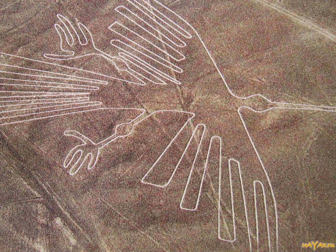
In accordance with the theory of scientists, all this was done by them once or twice. For some centuries, the Nazca plateau has turned from a lifeless valley into the most bizarre and richest territory in geoglyphs on the whole Earth. The first settlers crossed ravines and uplands, but at the same time their geometric lines, Nazca geoglyphs, remained perfectly correct, and the edges were strictly parallel, which seems incredible. In addition to stripes and trenches in the Nazca plateau, unknown craftsmen also created figures of various animals. From the air, they are seen, albeit bizarrely, but easily recognizable. Again, how the first people in these lands managed to depict, say, hummingbirds with such accuracy is categorically unclear.
The mentioned hummingbird, by the way, like many Nazca, reaches fifty meters in length. Another drawing bird, the condor, is 120 meters long. And the spider, similar to its relatives living in the Amazon jungle, boasts 46 meters in length. It is noteworthy that all these masterpieces of the Nazca plateau can only be seen by rising high into the air or climbing some mountain, which, unfortunately, is not nearby. From the ground and small hills, these drawings are indistinguishable and are a simple set of lines and trenches. Of course, you can make out individual silhouettes and strokes, however, full picture visible only from the air.
Obviously, the civilization that inhabited the Nazca plateau did not have any aircraft. Neither balloons, no planes, let alone missiles in prehistoric times didn't exist. So how could they recreate their drawings with such accuracy, without being able to evaluate the work done and find flaws in order to correct them?! This remains as much a mystery as the functionality of the Nazca images. Why were they created? Is it really just for the sake of aesthetic beauty, or maybe for some religious purposes? A question, a question, and another unanswered question.
It's hard for a modern person to understand logic. distant ancestors. We do not understand people who lived a hundred years ago, where are we to understand the motives of those who lived thousands, two thousand years ago. Is it possible that all the lines and images of the Nazca plateau have no practical component at all? The ancient people created them to show that they are capable of this. But why was it necessary to spend so much time and energy on self-assertion?! Wouldn't it be easier to unleash another war, in ancient times it seemed to be a much more common practice?!
Nazca drawings and related theories.
Scientists who are confident that a person is behind the creation of mysterious drawings on the territory of the plateau are no less than those who believe that Nazca drawings were created by an alien race. In their opinion, all the images and lines on the plateau are nothing more than runways. The version involving Peru, the Nazca plateau, of course, has the right to life, it remains unclear why the alien spaceships did not have a vertical take-off, or why create runways in the bizarre form of terrestrial animals? If you really wanted to stand out in this way, why not make a couple of drawings of Nazca in the form of fauna living in your world? However, it is better not to focus on this, because theories and conjectures regarding the motives of alien creators seem even more illusory than the motivation of the first people.

It is better to pay attention to this: Nazca drawings in the form of animals, birds and insects were created much earlier than simple triangles and other geometric shapes. This is not a confirmed fact, the theory is still in development, however, even now most scientists agree that this is so, complex Nazca drawings were created before simple images and trenches. Be that as it may, a simple conclusion suggests itself: did the unknown masters at first do more complex shapes, obviously created in several stages, and only then other people began to practice drawing straight lines and trapezoids. Or maybe for the long centuries it took to create the drawings for which the desert is famous Nazca on the map, did the masters of the ancient civilization lose their technology or simply forgot how to create complex images? All these are regular questions, the answers to which we, apparently, will receive very, very soon, if at all someday.
At the same time, there are isolated figures in the scientific community who believe that all the Nazca drawings were made in the same period. But what scholars agree on is the idea that individual members of the ancient Nazca people had knowledge of astronomy.
For example, Maria Reiche (1903-1998), a German mathematician and archaeologist who has been studying mysterious lines for almost 50 years, once claimed that the Nazca drawing in the form of a huge spider is very similar to the star cluster in the constellation Orion. Three straight lines lead to the figure, they supposedly served to track the change in the declinations of the three brightest stars in Orion's Belt: Alnitak, Alnilam and Mintaka.
There is another very entertaining theory involving the Nazca figures. Archaeologist Johan Reinhard, who is an American by birth, believes that the lines and figures of animals were part of religious rites, or at least were built for some religious purposes. The figures of animals, insects and birds were supposedly associated with the worship of the gods. With the help of Nazca drawings, people asked the celestials for water to irrigate their lands. It is not entirely clear how exactly this ceremony took place, but it doesn’t matter if it even took place at all? It is obvious that the ancient people were novices of the pagan faith and, as in any such religion, the cult of the gods occupies a central place not only in religion, but also in the daily life of people. It is likely that the Nazca civilization really carried out some rituals to worship their deities, but it is almost impossible to prove this.
Today, the attention of researchers from all over the world is focused not on the Nazca drawings and not even on the mysteries surrounding them. While people are guessing and guessing, a serious environmental threat looms over the plateau. Deforestation, air pollution do not change in better side balanced and almost unchanged climate of the plain. The Nazca Plate is facing problems: it rains more and more often, landslides and other misfortunes occur, one way or another affecting the integrity of the images. This is a very serious threat, and if nothing is done in the next 5-10 years, or maybe less, the Nazca drawings will be lost forever, and then there is no doubt that the answers to the questions posed by the research community will never be received. We will certainly never know who and why created this, without exaggeration, a wonderful and unique phenomenon.